Century of Progress Maps
by Judy Aulik
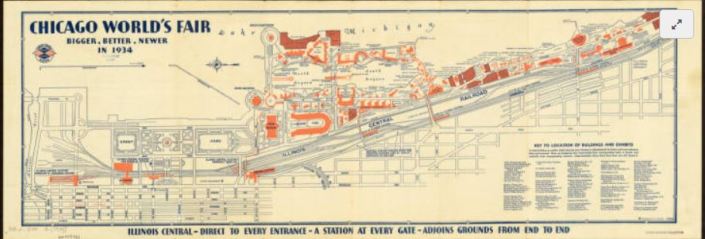
Chicago, celebrating an ill-defined centennial, hit the 40th anniversary of its 1892-1893 World’s Columbian Exposition with the Century of Progress fair of 1933-1934. Map publishers went into overdrive to commemorate the first large World’s Fair of the auto tourism era. Oil companies which commissioned these road maps for their gasoline brands include Barnsdall, Conoco, Deep-Rock, Diamond, Gulf, Lubrite, Pennzoil, Pure, Shell, Standard (Indiana), and Vacuum Oil. Both H.H. Gousha and Rand McNally produced many road maps for the occasion: some were essentially Chicago vicinity maps with an inset of the lakefront fair grounds. Some bore specially designed covers, such as those from Barnsdall and Pure. Others showed routes with a symbol celebrating each exhibit hall. Even post card manufacturer Curt Teich published a commemorative road map for its hometown!
But not every attendee drove. Many used the railroads instead. The Chicago & Northwestern Railroad was an obvious choice for those west of the city. However, five electric line stations plus the Illinois Central’s Central Station served the Century of Progress and the museums.
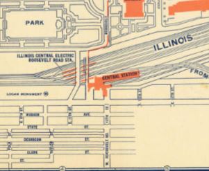
Although Chicago is a well-planned city, a city map and exhibit map would be welcomed by the tourist. In 1934, Illinois Central Railroad issued a Rand McNally map for this purpose.
Oddly, this is oriented east-west as opposed to a road map. By this time, the convention of using the top edge of the sheet being north was nearly universal. Lake Michigan comprises its top edge.
The Century of Progress Deco exhibit buildings do not survive, with the exception of a House of Tomorrow, on Beverly Shores, Indiana. Since 1997, the IC rail yards are greatly reduced, and Millennium Park occupies some of the area shown on this map. IC’s Central Station is demolished, but Chicago’s lakefront was returned to the people.
Click here to view the AGS Library copy in the Digital Map Collection
