Yugoslavia
All the News that’s Fit to Map
By Brendan Dooley
In order to keep troops around the world up to date on each week’s advances during World War II, the U.S. military developed Newsmaps, poster-sized weekly publications of geographically focused battle updates. This was a time, of course, before emails, Tweets and Instagram posts (let alone personal cellphones in every pocket), so for the sailor at sea or soldier in the woods, jungle or desert, posted Newsmaps (often literally attached to posts) might be the only regular news they would see.
The American Geographical Society Library collection recently added 30-plus Newsmap editions, growing its collection of them to 142.
Most of the Newsmaps featured news briefs on the front, keyed to either large maps or smaller insets and/or photos from the relevant theater of operations, and the backs often featured large instructional or propaganada-ish illustrations or large-scale maps detailing particular battle hot zones.
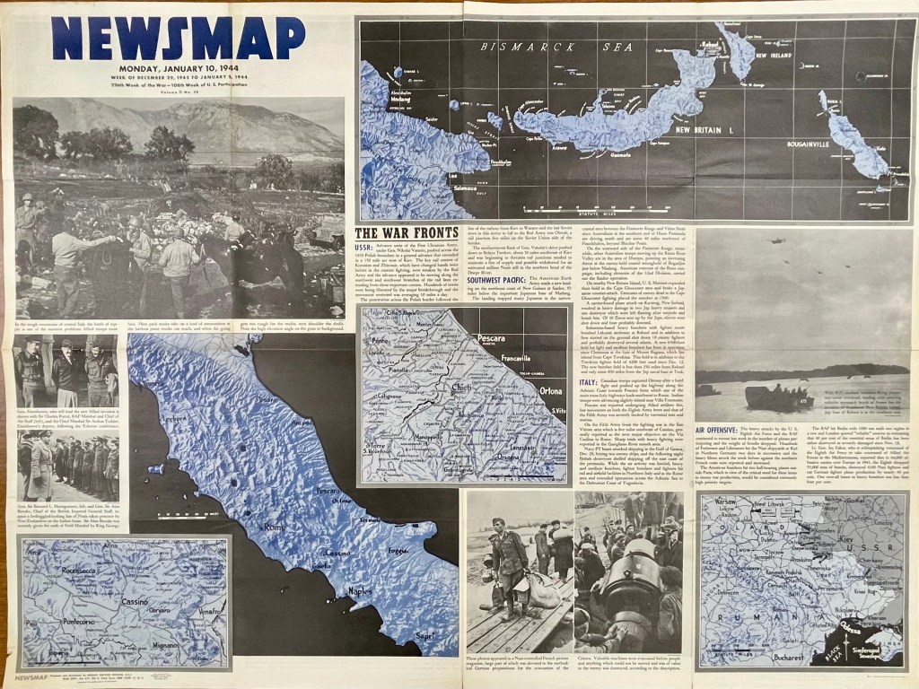
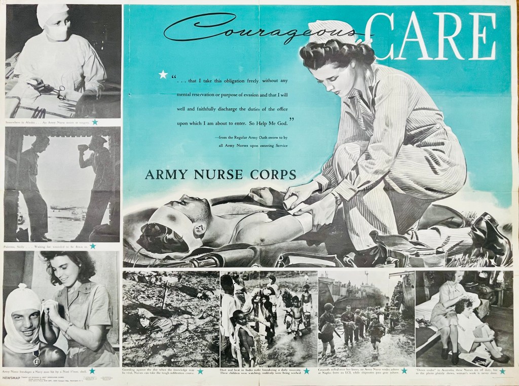

For instance, on the front of the Monday, Jan. 10, 1944, Newsmap (Vol. II, No. 38) are a collection of maps and images to go along with news briefs. The briefs that week covered the Soviet advance against Nazis in Crimea and Poland, U.S. movements against Japan on New Guinea in the Southwest Pacific, U.S. troop gains in central Italy and combined U.S. and R.A.F. bombing raids against Nazi-controlled munitions, plants and materiel in Northern Germany, Berlin and Paris (though no graphics with this last snippet). On the reverse of this Newsmap was a combined illustration and images detailing some ins and outs of the Army Nurse Corps.
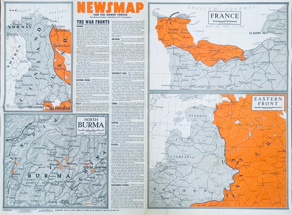
In another example six months later, the front of the Monday, July 3, 1944, Newsmap (Vol. III, No. 11F) includes briefs on the Allied seizure of the port at Cherbourg, France, Soviet advances in Finland, the Allied march north through Italy (now 120-some miles past Rome), bombing raids across Germany, Poland, Italy and Yugoslavia, Chinese and British troops taking Mogaung in Burma, U.S. Marine movements on Saipan, the new “Task Force 58” maneuvers near the Philippines and air operations in the Southwest Pacific. The back of this edition (Vol. III, No. 11B) detailed the importance of Teamwork, whether by army and naval forces in combined attacks or various Allied contingents in joint planning efforts and operations.
While blue was a dominant color of the Jan. 10 Newsmap, July 3 (on the front side) uses orange to highlight interest; from week to week, Newsmaps tended to feature one main color. Of note, the Newsmaps starting within Vol. II began denoting front “F” and back “B” sides to the editions. Additionally, there were Industrial editions of the Newsmaps—sent to U.S.-based munitions plants and military factories—that were usually similar in their news and layout on the front, but did not contain B sides. (More on these Industrial editions in a future post.)
The AGSL physical collection now includes 114 military editions of the Newsmaps across Volumes 1-5 (which ran from 1942-1946), as well as 28 of the Industrial versions from Volumes 2-4. Roughly two dozen of the new military editions and 15 of the Industrial versions were added after a donation from the Milwaukee County Historical Society.
You can come up to view them Monday-Friday, 9 a.m. to 4:30 p.m. in the AGSL on the third floor of the Golda Meir Library; which is open to the public as well as UWM students. (The extent of 212 Newsmaps is also available online at the University of North Texas here.
Cataloging, Sleuthing and Land Consolidation in Croatia
by Angie Cope
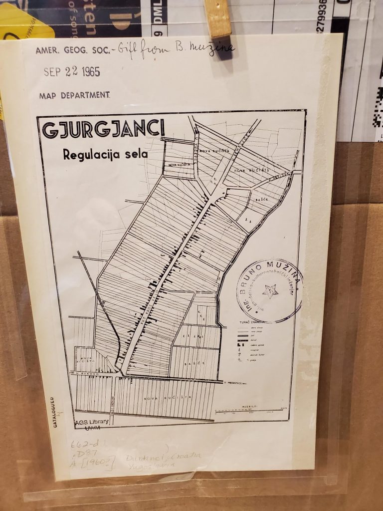
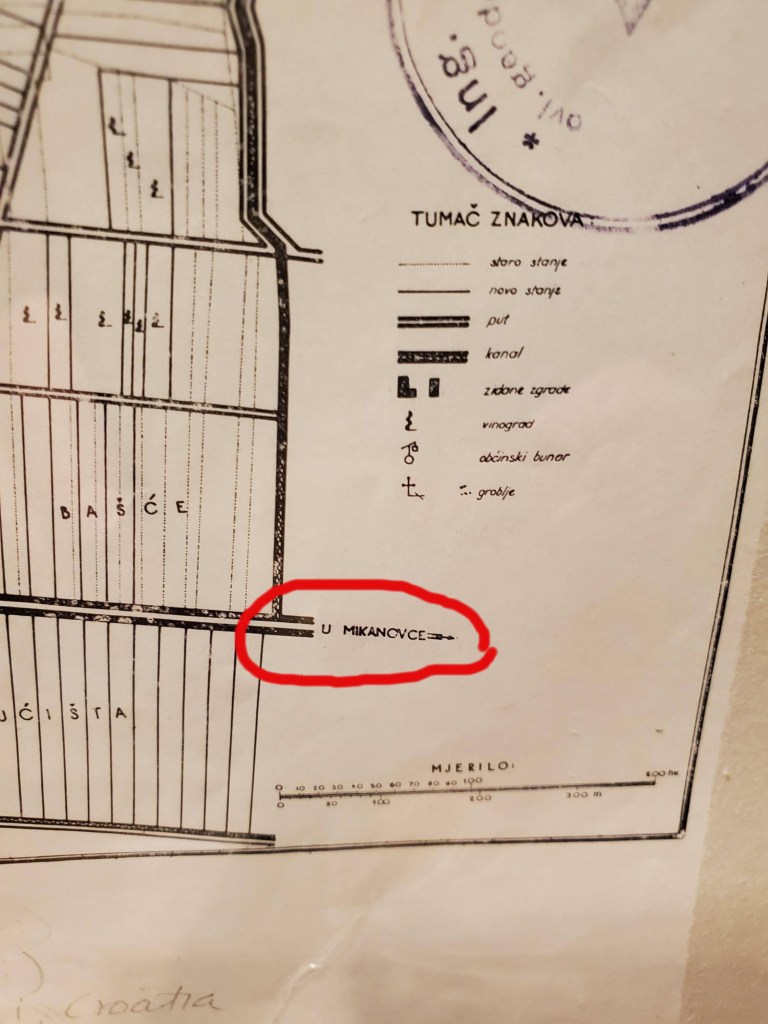
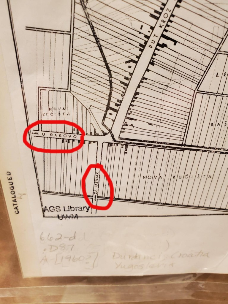
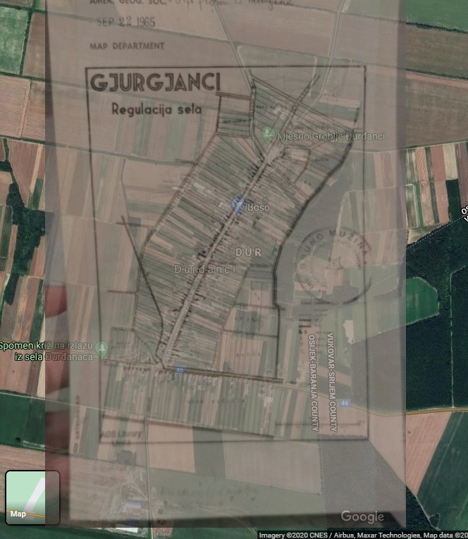
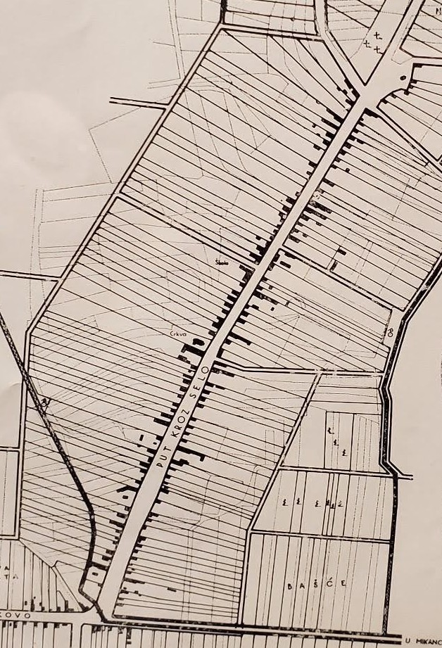
Recently I’ve been cataloging a back log of maps from Eastern Europe. If you’re familiar with the AGS Library’s situation, all our maps are cataloged – in an old fashioned card catalog. Efforts have been underway for … a long time … to get everything cataloged in the online environment. The other day I ran across this little map titled “Gjurgjanci Regulacija sela” (24 x 16 cm). After some detective work, I was able to identify the modern place name and some other interesting information about it.
A Google search for “Gjurgjanci” – took me to a place in Kosovo, but the details didn’t match. Gjurgjanci doesn’t show up in the Getty geographic thesaurus, the U.S. Board on Geographic Names or the Library of Congress subject heading authorities, so my detective work continued.
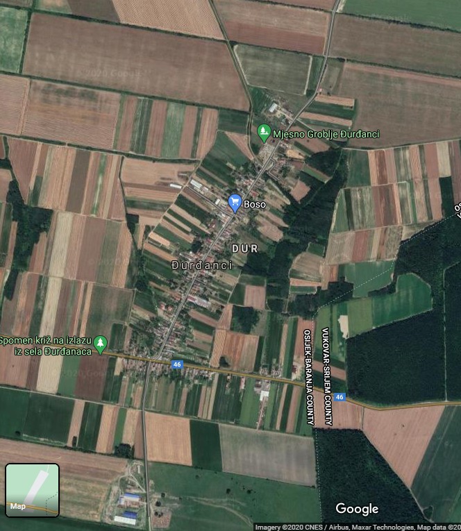
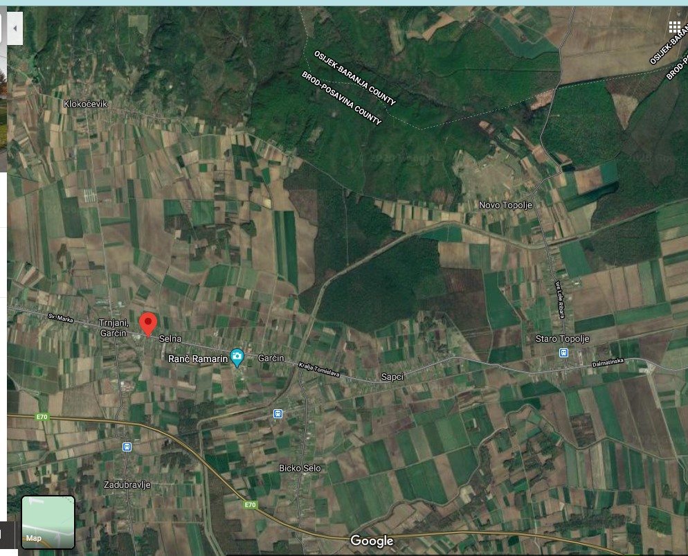
On the map, I noticed that some roads are labeled with directions to neighboring cities. I searched those place names until I zeroed in and identified the correct location of my map – Đurđanci in the county of Osijek-Baranja, Croatia.
It was great to learn WHERE the map was of, but I still didn’t know anything else about it such as subject, date or publisher. I cataloged that map as best I could and continued on my cataloging journey through Yugoslavia.
The next day I came across two similar maps with similar problems – I was not able to find the place name in a Google search, a Getty geographic thesaurus search or a Library of Congress subject heading authorities search.
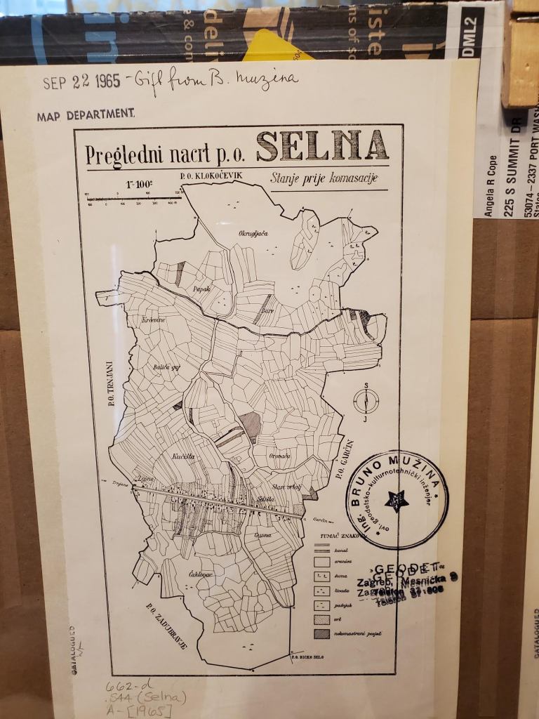
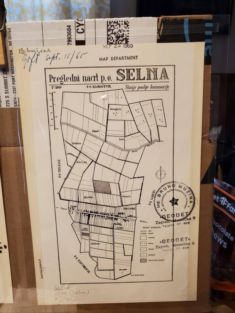
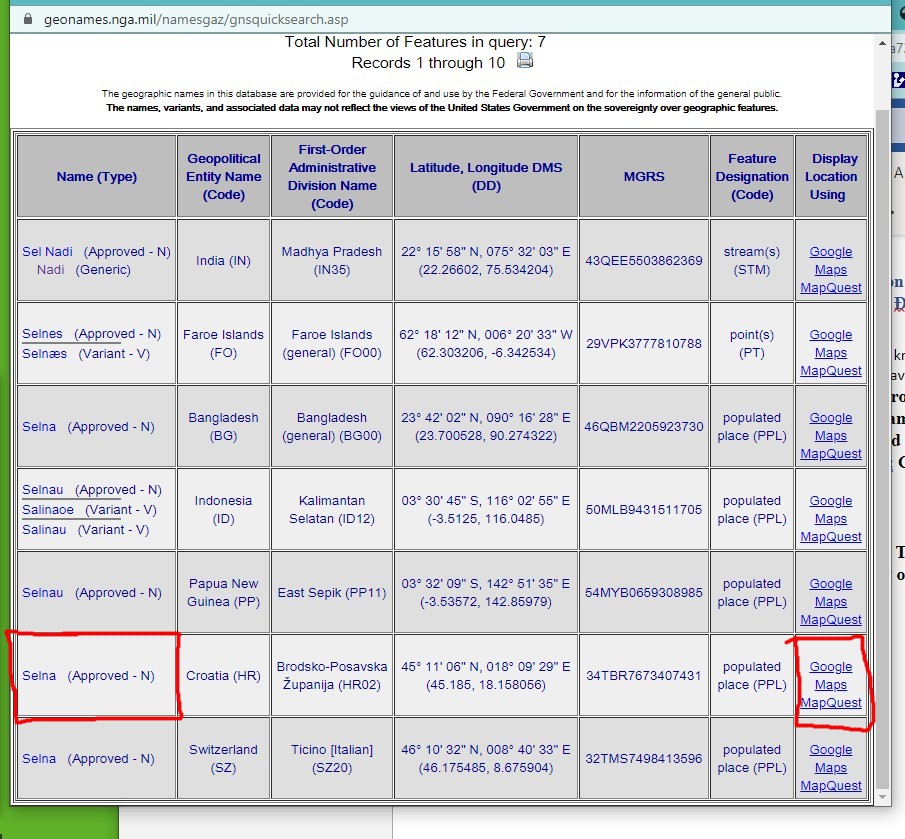
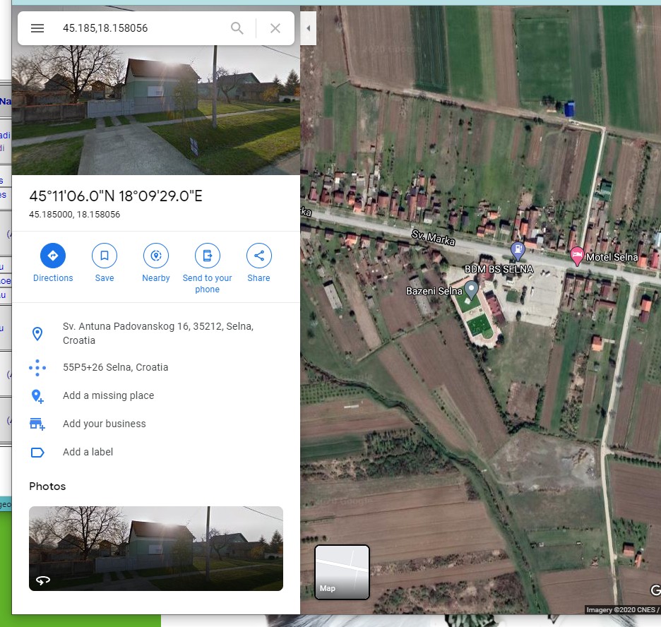
Fortunately, in this case, the US Board on Geographic Names site included a record for Selna. The search results at US Board on Geographic Names allow you to click on a link to the map. You can see the modern map lines up with details from these historical paper maps.
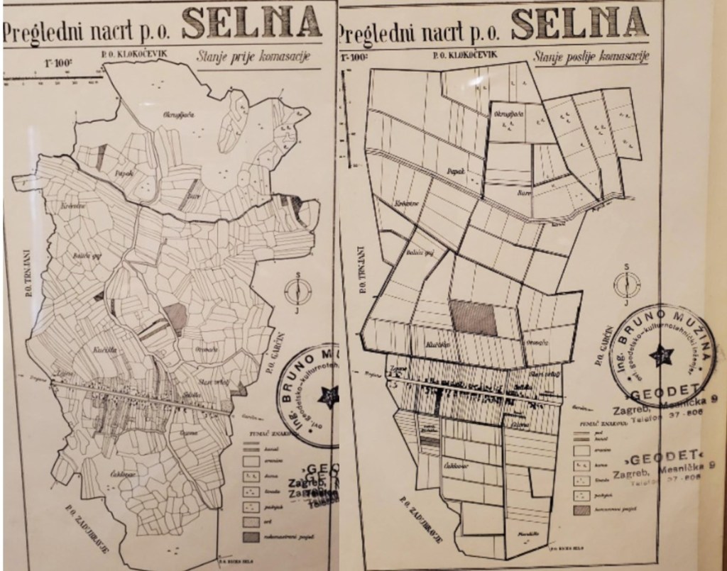
While I still don’t know much about these maps in regard to their date or publisher, I was able to learn that these maps show Croatian/Yugoslavian land consolidation. The subtitles on the Selna maps read: Stanje prije komasacije — Stanje poslije komasacije or Condition before consolidation – Condition after consolidation.
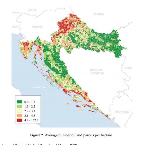
Apparently there have been multiple attempts to consolidate land in Croatia. Today, Croatia has approximately 14 million cadastral parcels and the total land area is 56,594 km2. Cadastral parcels are heavily fragmented (Figure 2). From the figure it is visible that average number of land parcels per hectare is relatively high.
Faculty of Geodesy, University of Croatia. Published: 9 March 2018
The maps held at the AGS Library were received as gifts from “Ing. Bruno Muzina ovl. Geodetsko-kulturnotehnički inženjer” in 1965. My guess is that he worked at “”Geodet” Zagreb, Mesnička” as indicated by the stamps on the maps. The publication date is at least 1965 or earlier based on the gift date. However, I don’t know an exact date or publisher or if the maps were removed from a report and if so, what report.
With this added knowledge, the details of the maps become quite interesting. The first map of Gjurgjanci/ Đurđanci has the consolidated property lines layered over the historical, fragmented parcels. The Selna maps have the two versions side by side. One can clearly see the fragmented historical parcels. The idea is that fragmented agricultural land raises the cost of agricultural production. The land consolidation effort would merge partitioned lands into larger and more regularly shaped parcels. Roads and canal networks would also be arranged to improve the conditions of agricultural production. Understanding a little more about both the where and the what my maps were showing is critical when assigning subject headings. In this case, I assign both the place names as well as a topical heading: Consolidation of land holdings — Croatia — Maps.
As a cataloger I make decisions about how far to proceed when creating data for my records. Do I continue to research this question, learn the Croatian language so I can read up on land consolidation, travel to Croatia to comb the local archives, conduct a séance? Or, do I make the decision to put as much information as I can, make educated guesses, include information in brackets and just move on with my life (see one of my cataloging records below).
Perhaps this blog will be seen by someone out there who can offer information about the publisher or date of the land consolidation being shown on my maps.
hashtags to consider … #workingfromhome #https://pixlr.com/x/ #pixlr_is_awesome #gettingbywithphonephotos #googlemapsrock #ilovecataloging
007 a ǂb j ǂd a ǂe a ǂf n ǂg z ǂh n
040 GZN ǂb eng ǂe rda ǂc GZN
0341 a ǂb 10000
043 e-ci—
090 ǂb
049 GZNA
24500Gjurgjanci Regulacija sela.
255 Scale approximately 1:10,000.
264 1[Place of publication not identified] : ǂb [publisher not indentified], ǂc [1960?]
300 1 map ; ǂc 18 x 13 cm, on sheet 24 x 16 cm
336 cartographic image ǂ2 rdacontent
337 unmediated ǂ2 rdamedia
338 sheet ǂ2 rdacarrier
500 Stamped: Ing. Bruno Muzina ovl. Geodetsko-kulturnotehnički inženjer.
500 “Gift from B. Muzina, Sep 22 1965.”
500 Đurđanci, Osijek-Baranja County, Croatia.
6500Consolidation of land holdings — Croatia — Đurđanci — Maps
651 0Đurđanci (Croatia) ǂv Maps.
650 0Cities and towns ǂz Yugoslavia ǂv Maps.
650 0Cities and towns ǂz Croatia ǂv Maps.
