cartography
Looking Back to the Golden Age of Pictorial Map-Making
By Lillian Pachner
Pictorial maps are a unique genre of map that highlights the geographic features of a region with illustrations. These illustrations may be of people, buildings, landmarks, plants, animals, or any number of concepts that can be represented on a map. Besides representational illustrations, these maps often include ornate compass roses, decorative boarders, and intricate cartouches. Often, pictorial maps do not take themselves too seriously, as they regularly have an air of whimsy or humor. Although the focus of a pictorial map is the illustrations, these maps also usually include text which expands on the information presented by the pictures. Pictorial maps are not usually meant to be used for navigational purposes. Rather, they are frequently used to promote tourism, or to commemorate historical events or eras. Many pictorial maps were created for and loved by children given their often brightly colored and stylized illustrations, but they are assuredly not only enjoyed by younger demographics.
By the late eighteenth and early nineteenth centuries, Americans began to view maps differently than they had in the past. Before this era, maps were mostly associated with scientific and navigational tools, despite decorative maps being a very old concept. Soon, maps became associated with the visual arts as well. Maps, of course, never lost their purpose as a tool, so throughout the eighteenth and nineteenth centuries, functionality and aesthetics both became integral factors in map-making. Pictorial maps as we know them today were born out of this intersection of cartographic science and decorative art.
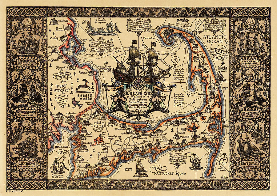
The Golden Age of Pictorial map-making in the United States lasted from about the mid to late 1920s through the 1950s. Some of the “big name” map makers of that time were Jo Mora, Coulton Waugh, Frank Dorn, and Ernest Dudley Chase. Coulton Waugh’s Map of Old Cape Cod, as seen below, is one of the most well-known pictorial maps in America. The works of some of these creators are represented in the AGSL collection.
Pictorial maps truly entered the American mainstream in the 1930s-1950s when both the LA Times and the San Francisco Examiner began dedicating entire pages to pictorial maps made by newspaper staff Charles Hamilton Owens (LA Times) and Howard Burke (San Francisco Examiner). Owens, by far the more prolific of the two artists, reached his peak of popularity during World War II. From February of 1942 through August of 1945, the LA Times published about two-hundred full page pictorial war maps in color, all drawn by Owens. This brought several pictorial maps into the homes and hands of almost every United States citizen.
Although pictorial maps are most often associated with the modern era, they date all the way back to the beginnings of Western cartography. For example, Joan Blaeu’s 1662 World Map has several illustrations representing the Hellenic Pantheon. Early modern cartography utilized an abundance of map decorations, especially in the boarders and margins. These illustrations, while being predecessors to those of the pictorial golden age, serve a different purpose than their modern counterparts. While the illustrations in the pictorial maps play an active role in communicating the purpose and contents of the map, these earlier illustrations are, for the most part, purely decorative. They sometimes have very little relation to the subject of the map that they inhabit. The medieval mappamundi is an early iteration of pictorial map. The oldest and most well-known map in the AGSL collection, the Leardo (below), is a mappamundi. It includes illustrations of landmarks and structures in their approximate locations and has an ornate decorative boarder which consists of the saints’ calendar, and various other illustrations of angelic figures and animals. The Leardo would have been a decorative item, and would not have been a sufficient navigational tool, making it closely related to its modern pictorial successors. One may be familiar with the American Geographical Society’s participation in the #MapMonsterMonday social media trend. Maps with these monsters, while not being pictorial maps as we know them today, have these pictorial elements. These map monsters are the ancestors to the modern pictorial illustration.

Pictorial maps can serve many purposes and represent endless themes. Besides war maps, there are Pictorial maps that tell stories and histories, show locations of tourist traps, and even document fictional journeys. For example, Edward Everett Henry’s 1956 map titled The Voyage of the Pequod from the Book Moby Dick by Herman Melville (below), recounts the narrative from the famous novel. Henry had a predilection for fictional pictorial maps, as he also created the 1960 map, The Virginian: From America’s First “Western” Novel Written by Owen Wister, another map based on a novel. Stephen J. Hornsby is one of the leading experts on pictorial maps, and one of the most prolific authors on the subject. Hornsby says that, while there are things, such as accurate navigation, that a pictorial map commonly does not provide, they include certain elements and themes that a more traditional map cannot such as memory, history, emotion, fun, humor and pride of place/region.

Reading List
“About Pictorial Maps.” George Glazer Gallery Antiques. Accessed December 28, 2022. https://www.georgeglazer.com/wpmain/about-pictorial-maps/.
Brückner, Martin. “Maps, Pictures, and the Cartoral Arts in America.” American Art 29, no. 2 (2015): 2–9. https://doi.org/10.1086/683346.
Cosgrove, Denis. “Maps, Mapping, Modernity: Art and Cartography in the Twentieth Century.” Imago Mundi 57, no. 1 (2005): 35–54. http://www.jstor.org/stable/40233956.
Miller, Greg. “Geography Isn’t Sacred in the Playful World of Pictorial Maps.” Culture. National Geographic, May 3, 2021. https://www.nationalgeographic.com/culture/article/geography-playful-world-pictoral-maps.
Picturing America: The Golden Age of Pictorial Maps. 2017. Video. https://www.loc.gov/item/webcast-7930/.
“The Golden Age of American Pictorial Maps.” The Golden Age of American Pictorial Maps | Osher Map Library. Accessed December 28, 2022. http://oml01.doit.usm.maine.edu/exhibitions/pictorial-maps.
Riding the Rails through Wisconsin
By Lillian Pachner
The beginning of the rail age in North America is marked by the construction of the Baltimore & Ohio Railroad in 1827. Quickly, cities across the young country saw the benefit of being connected by rail. In particular, Milwaukee’s city boosters (people whose job it was to essentially “promote” a city to outsiders), immediately recognized that the emerging national network of railroads would provide local farmers, craftsmen, and manufacturers with access to a larger market. If Wisconsin wanted to keep up with the surrounding cities, it would have to build a railroad.
Wisconsin’s first railroad was the Milwaukee and Mississippi railroad. Construction for this line began in 1847. This railroad was originally called the Milwaukee and Waukesha Railroad. It was the first passenger line to connect Milwaukee with Waukesha. The construction of this railroad was part of the attempt to connect Milwaukee with the Mississippi River. The construction for the second rail line, the Lacrosse and Milwaukee Railroad, began in 1852.
While Milwaukee never became a giant rail-based metropolis like Chicago or St. Louis in the late 1800s, Milwaukee was still able to make its name as a decently large rail-hub. Though the banking crisis of 1857 meant that railroad construction was slow going for a time, banker Alexander Mitchell’s emergence in the industry marked an uptick in Milwaukee’s rail building.
Alexander Mitchell, along with his business partner and mentor George Smith, both Scottish Immigrants, made a large part of their respective fortunes during the Banking Crisis of 1837, twenty years earlier. Mitchell served as secretary for Smith’s company, The Wisconsin Marine and Fire Insurance Company Bank. The company’s insurance charter allowed them to circulate certificates of deposits as if they were currency (these deposit slips were called “George Smith’s Money”), which allowed them to amass a fortune while actual banks were failing. Though the legality of this practice is dubious at best, Mitchell became the wealthiest person in the state by 1860.
Mitchell’s fortune allowed him to supplement and restructure Milwaukee’s existing railroads. He organized the Milwaukee and St. Paul Railway, and other rail construction projects that connected and renamed some of the existing lines. Mitchell’s work helped Milwaukee grow into a hub for wheat shipment in the Midwest. For a time, it rivaled even Chicago on this front.
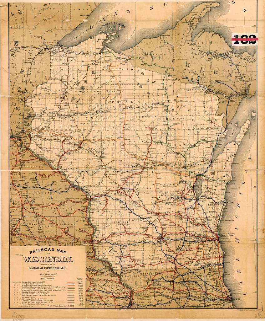
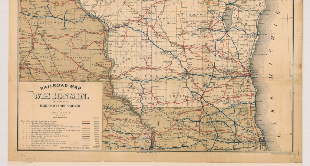
The map above, created by Allan Connover in 1887, (the year of Mitchell’s death) shows the major rail lines going through Wisconsin at the time. This is one of several rail maps available for viewing at the American Geographical Society Library (AGSL) in the Golda Meir Library on Campus. Several of these maps may also be viewed online through the AGSL Digital Collection.
The AGSL is open Monday-Friday, 9 a.m. to 4:30 p.m., on the third floor of the Golda Meir Library at UWM’s campus.
Map Citation:
Connover, D. Allan. Railroad Map of Wisconsin / Prepared for the railroad commissioner by Allan D. Conover C.E. [Map]. 1:760,320. 1 in. = 12 miles. 1887. Link to map on Digital Collection
Sources Cited:
Campbell, Stephen. “Panic of 1837.” The Economic Historian. November 12, 2020
Grant, Roger H. “Railroads”. Encyclopedia of Milwaukee. 2016.
Harding, Bethany. “Alexander Mitchell.” Encyclopedia of Milwaukee. 2016.
Leonard, David Blake. A Biography of Alexander Mitchell 1817-1887. Madison, WI: University of Wisconsin, 1951.
Langill, Ellen. “Banking Industry”, Encyclopedia of Milwaukee. 2016.
Smith, Alice Elizabeth. “George Smith’s Money.” Wisconsin: State Historical Society of Wisconsin, 1966.
End of an era — The Seeger Map Company, Inc. closes their doors
by Angie Cope
The Seeger Map Company, a mainstay in the map world, announced it will be closing the business by the end of 2020. The first Seeger maps were those drawn for motel guests on scraps of paper in the late 1960s. Eventually, the company would distribute 2 million maps a year and employ 27 people in their Racine, Wisconsin offices. One thing is for sure, the enduring legacy of Seeger Map Company will live on in homes and libraries across the United States, and abroad.
Norman Seeger Sr. was a sergeant with the Racine Police Department and he also built the Seeger Motel on Durand Avenue in Racine, Wisconsin.* The motel catered to visiting business people who frequently asked for directions. No local map of Racine existed, so Norm Sr. sketched directions on a piece of paper. He wearied of that task and started passing out mimeographed copies to his guests.
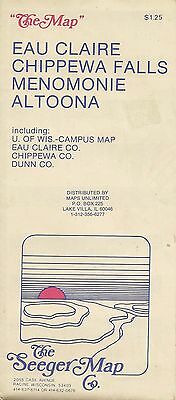
From the beginning, Norman Sr. was assisted by his son, also named Norman. They saw an opportunity to provide local maps and partnered up with Ed Raymond who had been printing specialty products for banks, realtors, hospitals and churches. Seeger and Raymond produced their first map of Racine with advertisements and coupons in the margins. The business was called “Seeger’s Local Map & Directory Company” because a page sized directory/index was included with the map.
In the early days the business was part time and most activity happened during the summers when Norman Jr. wasn’t busy with his teaching job. Norman Jr. attended Dominican College and Purdue University and taught chemistry, math and computers at St. Catherine’s School in Racine. The business was a family affair involving children, a niece and many family friends. A light table and all the accompanying manual tools were set up in the basement of the family home. A family friend engineered a device that created plastic wrappers for the maps and then family members packaged and labeled maps for distribution. In the early 1970s, Norman Jr. contacted the geography department at Carroll College to hire a cartographer to help create some of their first maps of Waukesha, Milwaukee and Madison.
The early maps were blue and red ink on white paper. Printing of maps was handled by Angel Lithographing, Burton & Mayer and Badger Printing.
By 1980, the business became more than the family basement could handle and the company purchased the 401 Main Street building in Racine. By this time, Dan Bartelt had been hired as the company’s first non-family employee and he helped aid the transition from the basement to a successful company. Eventually, Seeger purchased 403 Main Street as well to accommodate the growing business.
Norman Jr. wasn’t one to jump on the latest fads and trends but did eventually adopt the use of technology for his map making. He worked with Waukesha County friend Dave Stack to build a Computer Aided Drafting (CAD) program that transitioned the company from paper to digital.
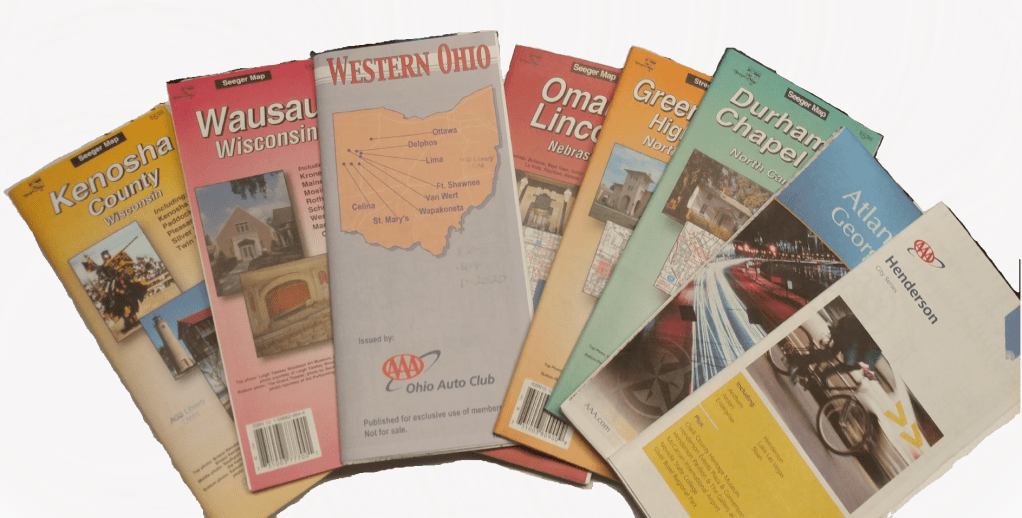
Another milestone for the Seeger Map Company occurred in the late 80s when they began to design and produce maps for customers outside Wisconsin for the Ohio Auto Club, and for the Franklin County, Ohio, Engineering Department. In the early 90s a landmark relationship was launched when the Carolinas Motor Club contacted Seeger for map design. Affiliation with the American Automobile Association (AAA) soon followed and the relationship quickly grew to included other state and national level clubs. Eventually, more than 80% of Seeger’s business was with the AAA clubs.
Norm Jr. resigned his teaching position in 1989 to become the sole owner of Seeger Map Company and to devote his full attention to the company. At the height of the company’s success in the mid-1990s, they employed 27 people and produced 2 million maps a year. The company still employed family members such as Norm Jr.’s daughter Becky who paid her way through college as an indexer, a task she did completely manually. Norm Jr. and his wife Carol scheduled their family vacations around map making. They’d drive up and down the streets of places like Branson, Nashville and Gatlinburg recording business names and points of interest. Norm and Carol wrote their notes on enlarged printouts of Seeger maps that they’d then give to the cartographers to update the computer files. Examples of these manuscript maps will be housed at the American Geographical Society Library at UW Milwaukee.
By the 2010s, Norm Jr. had semi-retired from the company and left the daily operations in the capable hands of Dan Bartelt and the cartographers, and Sandi Knorr, the company Administrator. Unfortunately, Bartelt passed away unexpectedly in 2013 at the age of 55. Norm Jr. had to come out of retirement to restructure the business. He never did quite fully get to retirement before he died in 2018. According to Norm Jr.’s wife Carol, he was nonetheless happily reaping many benefits of years of hard work and wise investments that came from running a successful business.
The American Geographical Society Library holds over 700 maps made by The Seeger Map Company, Inc. and there are over 3,000 titles held at libraries from around the world according to worldcat.org. Seeger succeeded while other paper map companies gave way to the changing times. Norman Seeger Jr. and The Seeger Map Company are respected names in local, regional, and national cartographic production. To say that their legacy will live on, is an understatement.
A special thank you to Becky Seeger Jenn and Carol Seeger for speaking with the author and sharing their stories.
*The motel was built in 1960 by Norman Seeger Sr. and his wife. The name was changed in 1970 to The Seeker Motel when ownership changed to Mervin Brandt, who had previously served as Pewaukee village president. Brandt died in 1975. The motel still rents rooms today, just a few blocks from the lakefront.
_____________________________
https://collections.lib.uwm.edu/digital/collection/agdm/id/12691/rec/2 
https://collections.lib.uwm.edu/digital/collection/agdm/id/12691/rec/2
_____________________________

According to the following table, compiled by Joe Tomich, Librarian at UW Milwaukee Libraries, there are 2,994 Seeger Map Co. maps in WorldCat. The Library of Congress has been receiving copies of Seeger maps and holds 1,669 (cataloged, likely some uncataloged as part of their backlog). The AGS Library at UWM holds 788 Seeger maps.
Because many of Seeger’s early maps didn’t list a date, catalogers guessed at a date and the same map may have been cataloged more than once but with different dates.
You can view or download the following table as a pdf file.
A list of all the companies and organizations affiliated with Seeger Map Company, Inc. over the years (click on image for a larger view).

PDF version of this list:
Beautiful countryside makes beautiful maps : The Alps in Austria
By Angie Cope
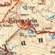
There is a beautiful set of maps dating from 1913 by map great G. Freytag. The American Geographical Society Library has 7 from this 1:100,000 series and they’re packed full of information. From a distance, the maps appear to be basic topographic maps, but if you look closely and think about all the detail you can imagine the complexity of human and natural interactions. Viewing the maps along with photos from the AGS Library photo collections, you begin to understand that this is both a snap shot in time and a reference for the present.
G. Freytags Skirouten-Karte des Ennstales und der Rottenmanner Tauern (G. Freytag’s ski route map of the Enns Valley and the Rottenmanner Tauern)
1913
https://collections.lib.uwm.edu/digital/collection/agdm/id/12013/rec/1
Liezen Torfstich or peat bogs.
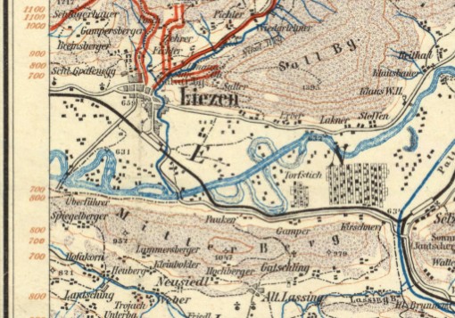
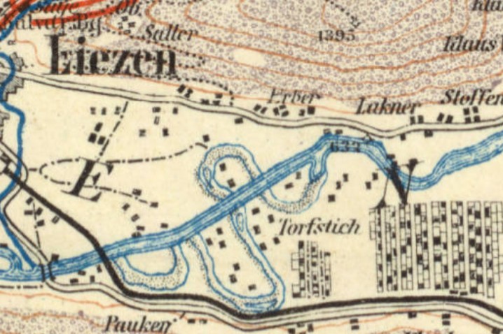
The above-ground extraction of peat is referred to as peat cutting. This organic material, which is created in bogs from the carbon from dead plants, serves as a low-energy fuel, to improve soil ventilation in horticulture and to a small extent also for the production of textile fibers and for medicinal purposes.
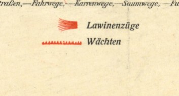
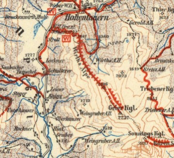
Interesting map symbology for avalanche warnings. (click on any image to see a larger view)
Photos from from the Eugene V. Harris collection between 1937 and 1969 showing the beauty of the region. (click on any image to see a larger view)
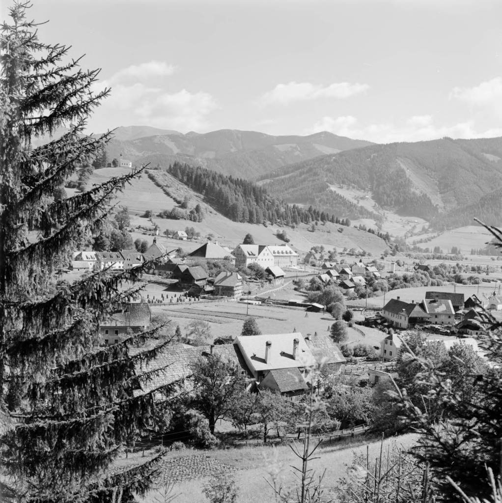
Austria, view of town of Oberzeiring from hill
https://collections.lib.uwm.edu/digital/collection/agseurope/id/1508/rec/1
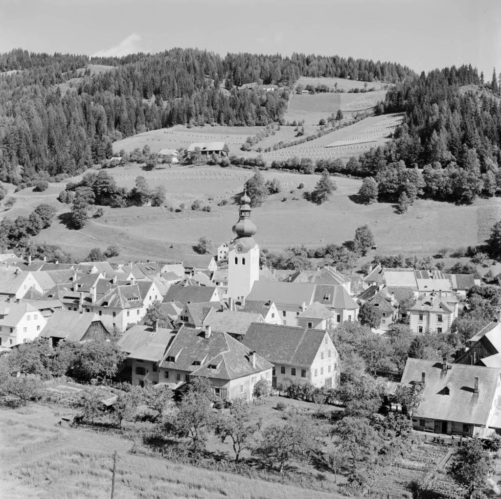
Austria, view of Oberzeiring and hillside with St. Nicholas Church tower
https://collections.lib.uwm.edu/digital/collection/agseurope/id/1250/rec/13
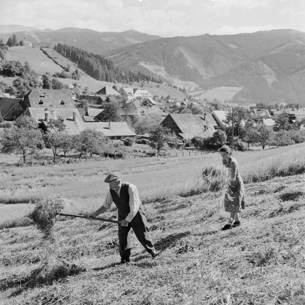
Austria, people raking hay in field in Oberzeiring
https://collections.lib.uwm.edu/digital/collection/agseurope/id/1690/rec/17
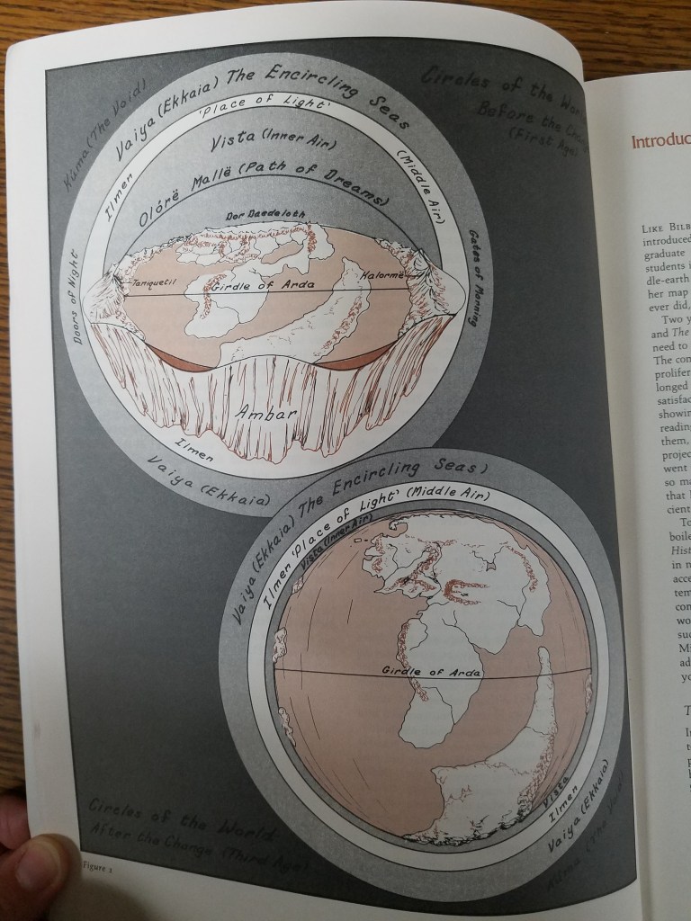
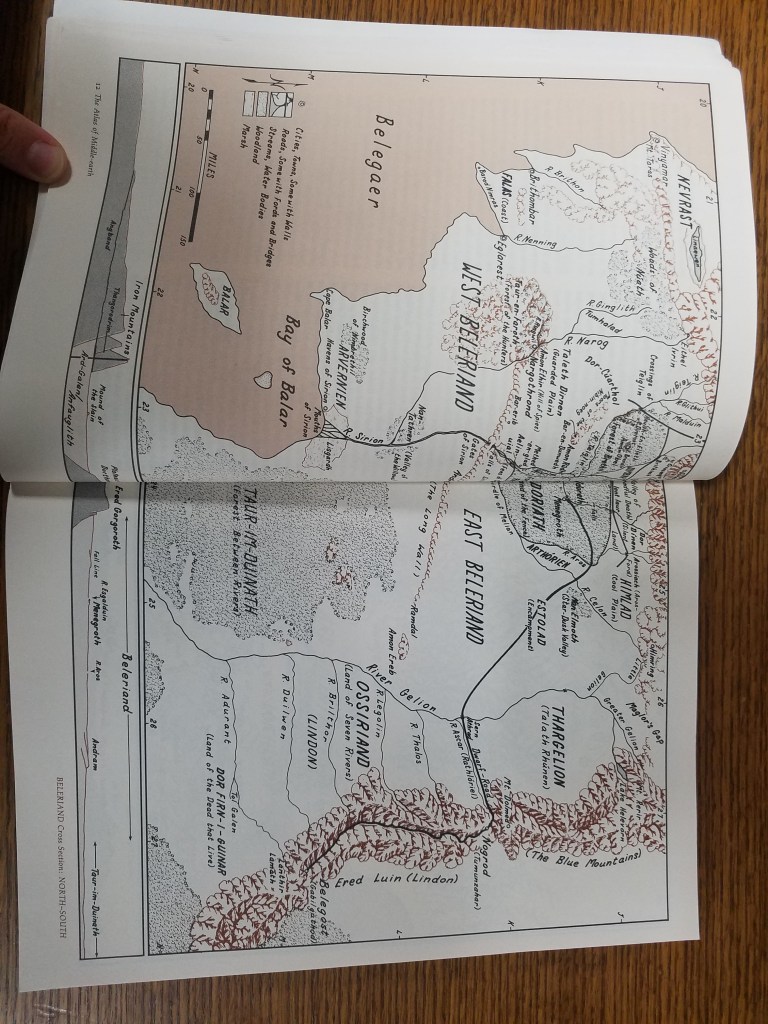
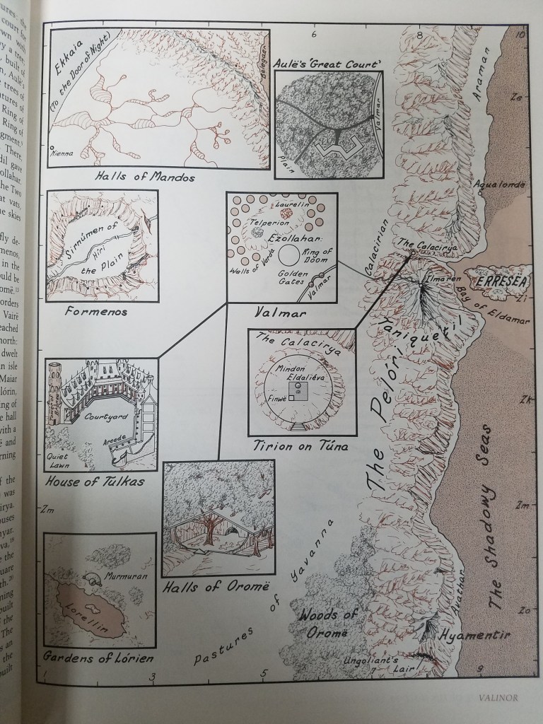
Mapping Fantasy Land: Karen Wynn Fonstad
By Lauren Maddox
J.R.R. Tolkien’s stories pushed fantasy into the mainstream and have passed through the hands of generations of eager fantasy readers. The genre was forever different after The Lord of the Rings— and people still love Tolkein’s works!
Part of the allure of fantasy for many readers is the chance to escape to another, fully-formed world. This is one of the reasons that speculative fiction has become such a thriving genre and why games like Dungeons and Dragons are now more popular than ever– not just because of Stranger Things.
But when you construct an immersive world that people want to become a part of, you have to answer a lot of practical questions about the layout of your world. You are tasked with mapping a place that doesn’t physically exist.
Worry not, fantasy fan! It’s not an impossible job to map fantasy land– and it was job beautifully done by one of the University of Wisconsin’s own: Karen Wynn Fonstad.
Fonstad received her MA in Geography with a specialization in Cartography from the University of Oklahoma. She went on to become the Director of Cartographic Services at UW-Oshkosh and was heavily involved with Oshkosh’s city planning. In 1970, she stepped down from her position as Director in order to raise her two children. But during this time she worked on several exciting fantasy atlases: The Atlas of Middle Earth, The Atlas of Pern, The Atlas of the Land, The Atlas of the Forgotten Realms, and The Atlas of the Dragonlance World. Fans might recognize some of those names from Tolkien, D&D, Anne McCaffrey’s science fiction and others. Fonstad’s work meant a lot to fans of those worlds, who felt like the atlases were a way to connect to the worlds they loved so much.
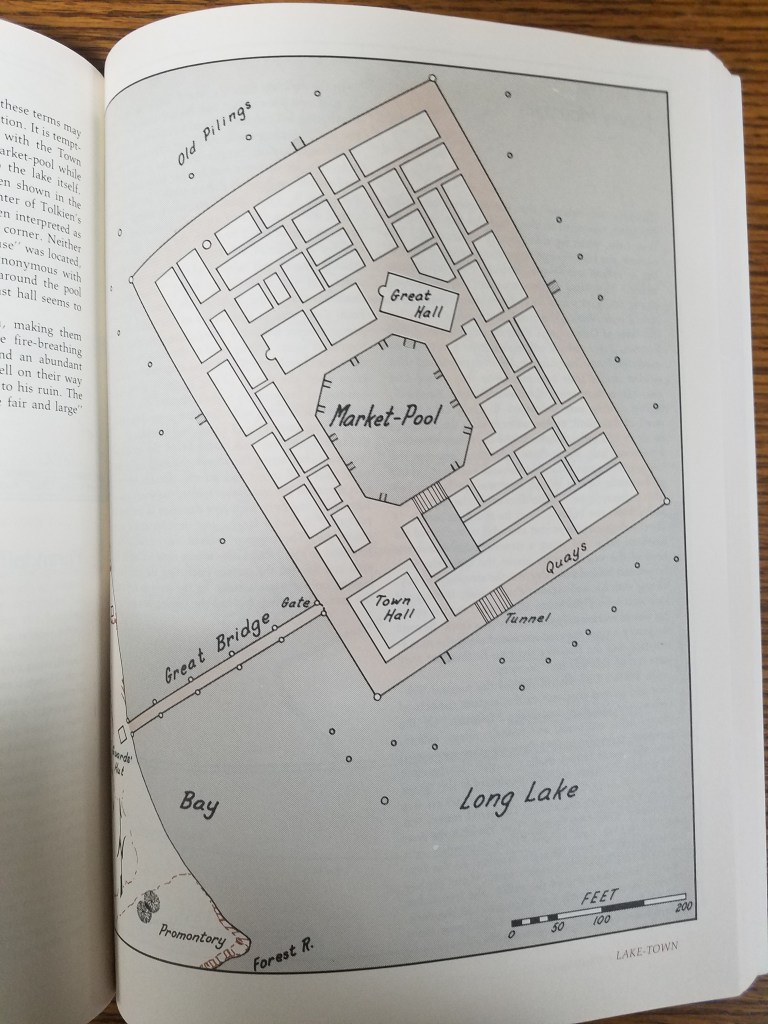
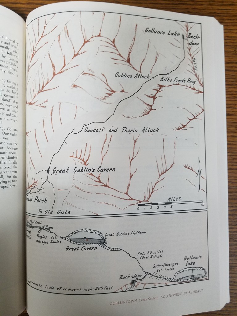
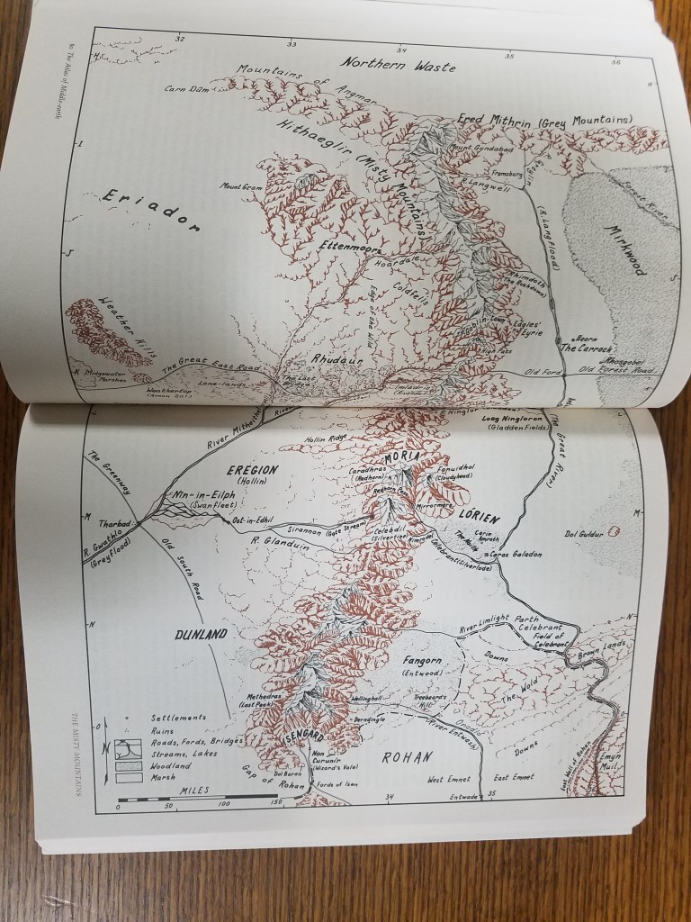
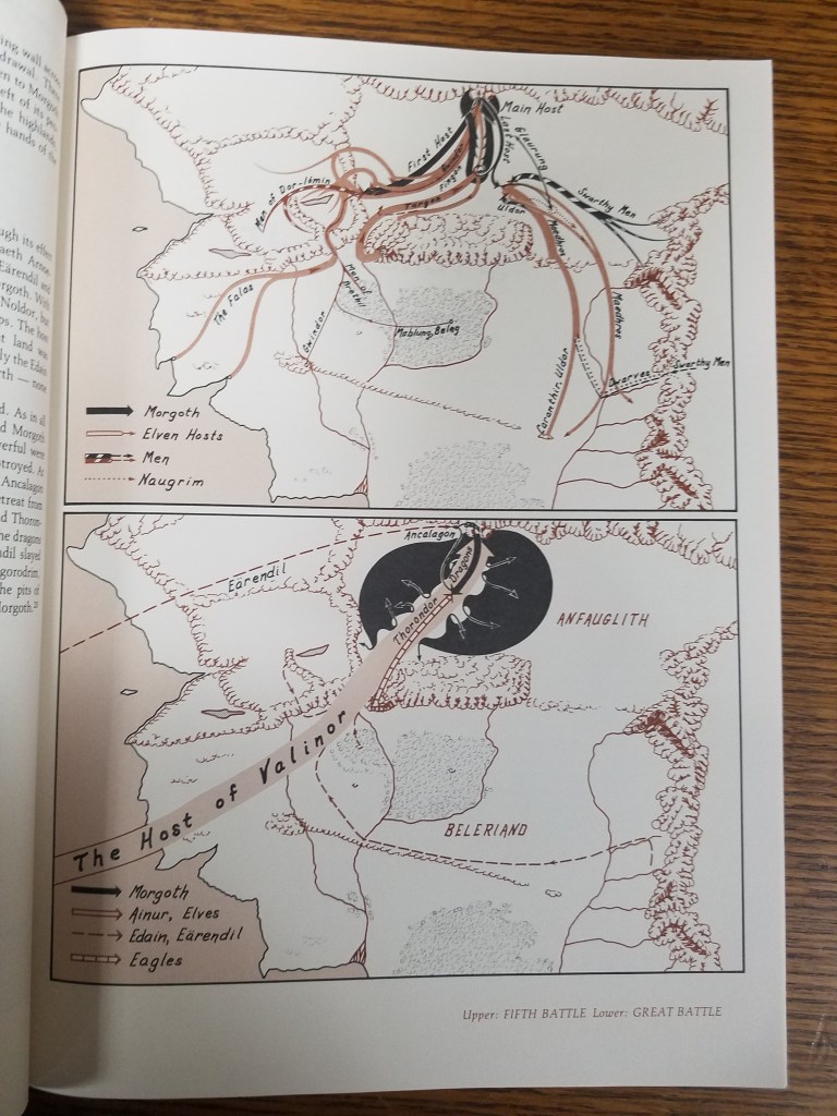
Fonstad passed away in 2005, but her work continues on in the hearts of those who were touched by her dedication to mapping fantasy lands. In the AGSL there are multiple atlases by Fonstad including her revised Atlas of Middle Earth, from which selections throughout this post were taken.
Cartographic Craftsmanship
by Sam Balistreri-Daum
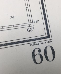
One aspect of the 19th and 20th Century nautical charts that continues to amaze me is the craftsmanship. I am currently working on the AGS Library’s set of Argentinian charts. Working with charts in a variety of languages means learning the various nuances of how the language is used in cartography, especially abbreviations. One abbreviation that had us scratching our heads for a little while was “dib.”, which we would see in the bottom right margin of the sheet accompanied by a name. I later found that this stood for dubujado or drawn and was again impressed by the level of craftsmanship and precision that is involved in cartography, especially in the days before computers.
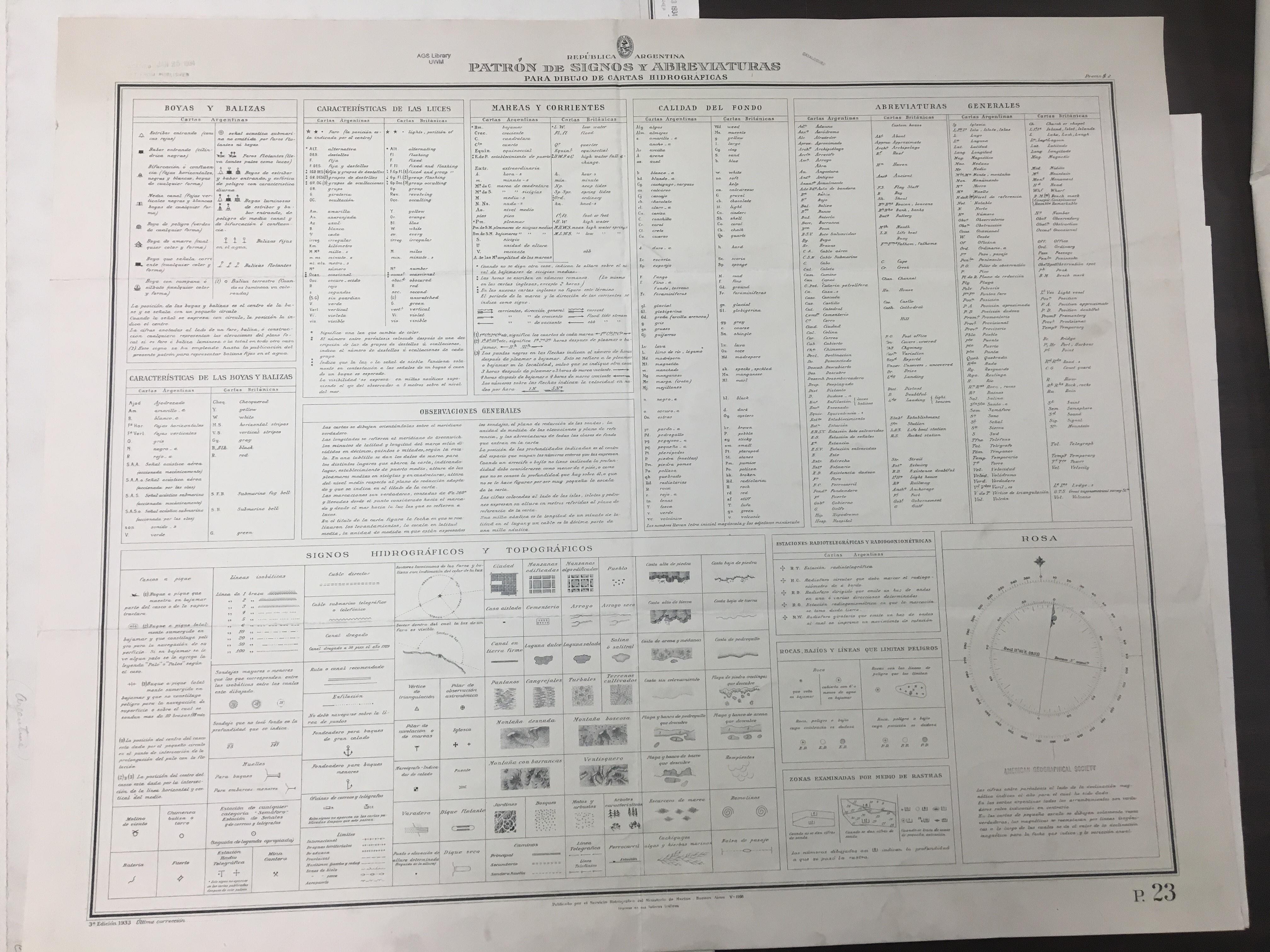
While cataloging the Argentinian charts I came across a chart containing keys for abbreviations, signals and topographic and hydrographic symbols used in the drawing of the charts in the series. This is a reference guide for those who would use the charts. Note the variety of styles that were done by hand before maps were engraved and then printed (click the image for an enlarged view).


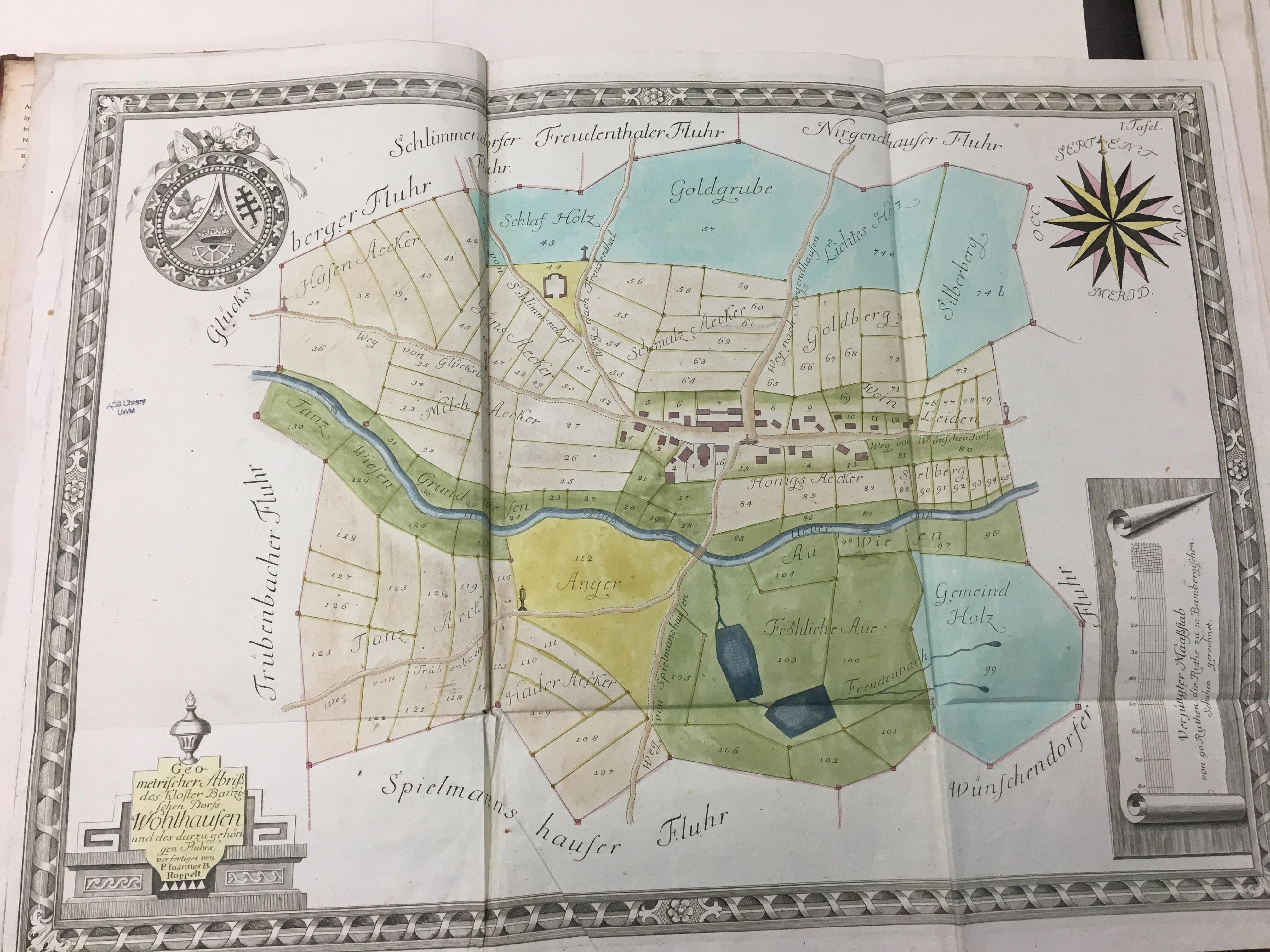
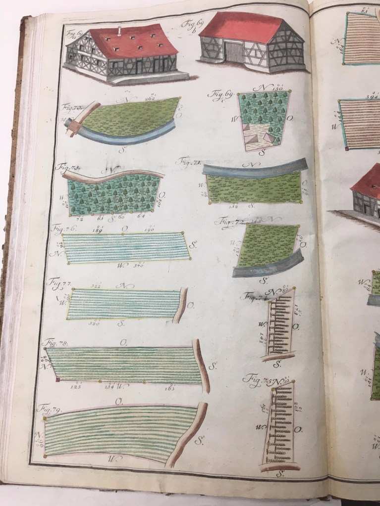
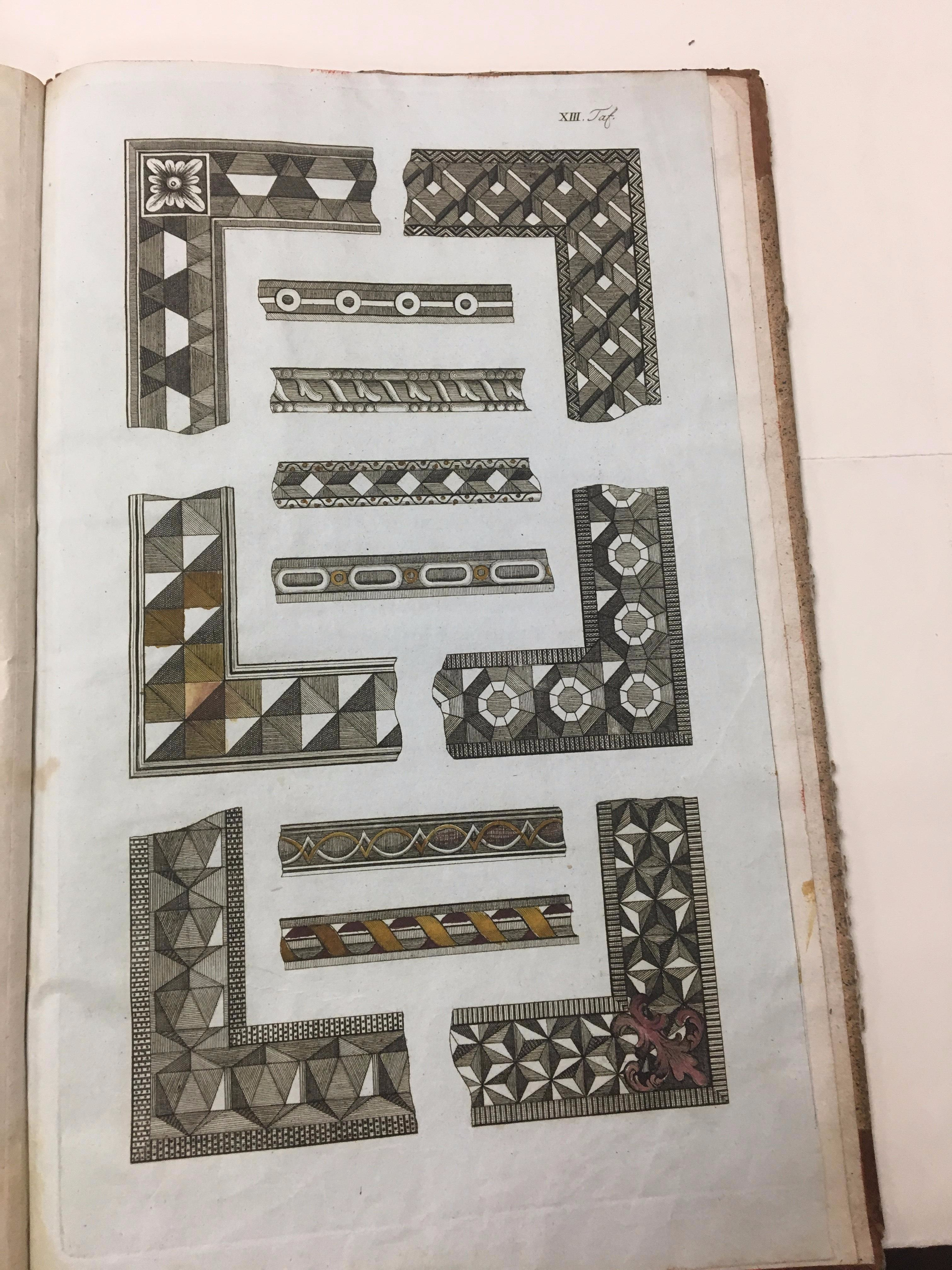
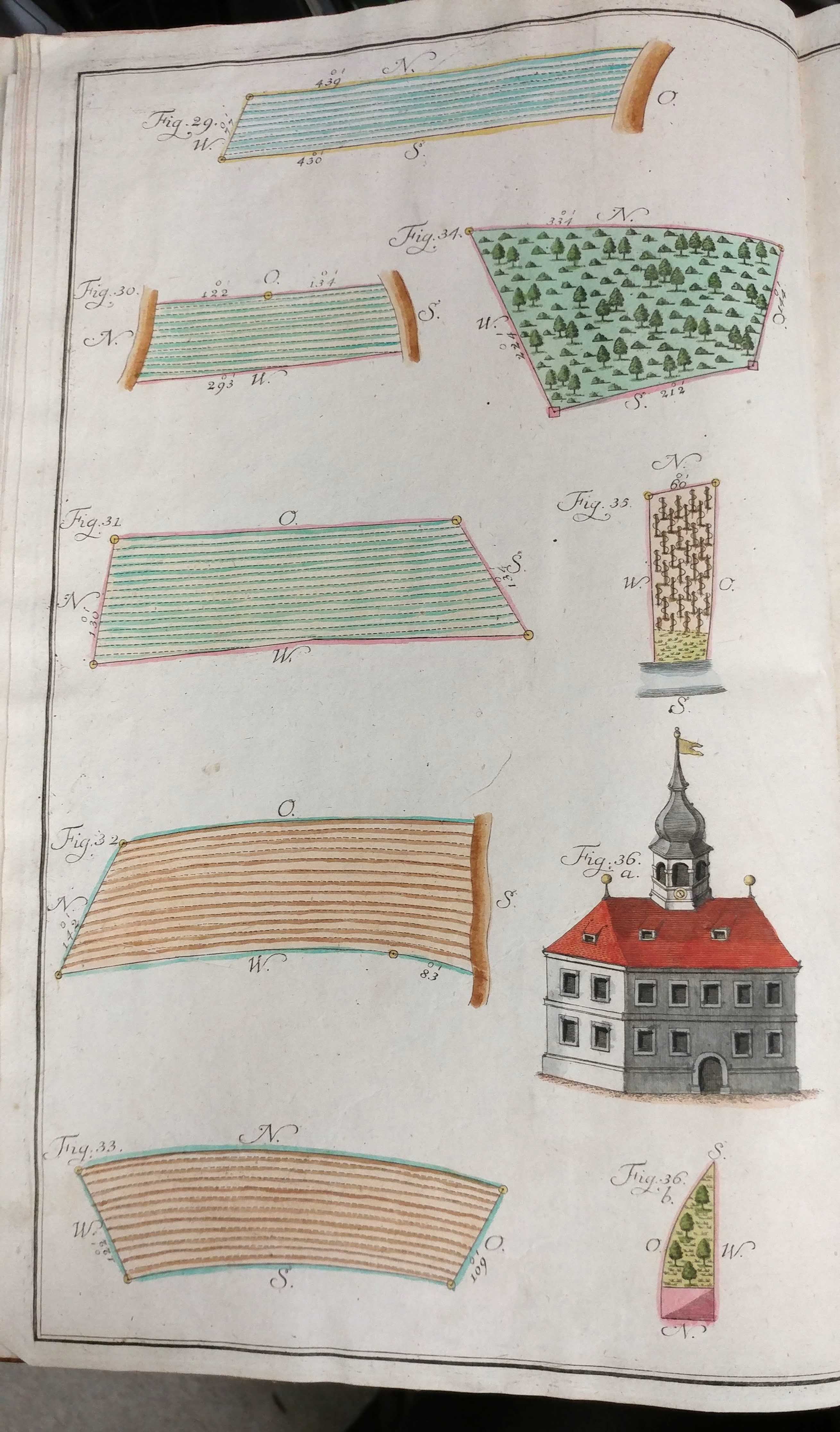
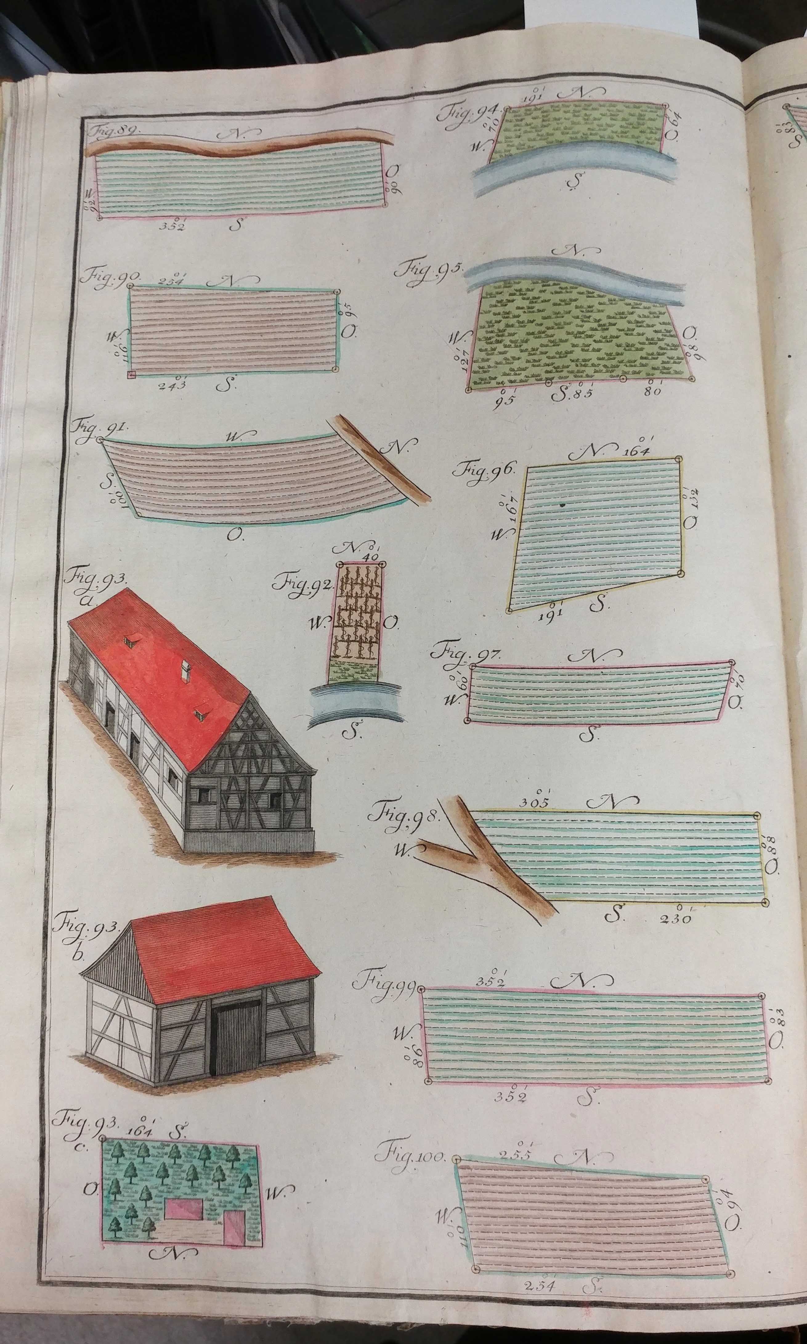
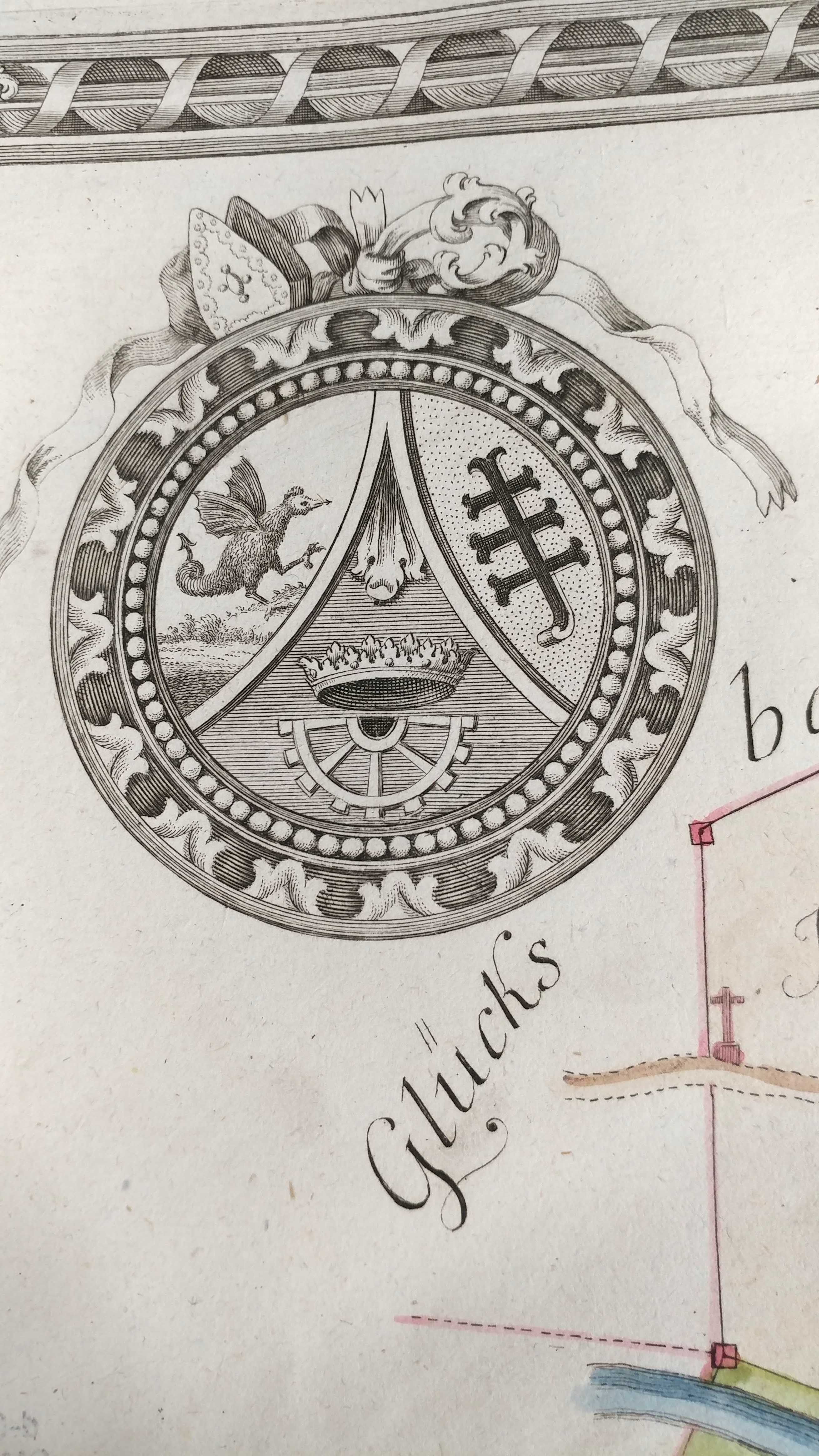
…And now for something different but related. How did a cartographer learn the skills necessary to draw maps? For an example of this we turn to the Practischer Entwurf eines neu zuerrichtenden Urbariums (1792). The book contains practical illustrations of (fictional) maps meant as a “how to” guide for cartographic drawing. This volume contains beautiful colored examples of cartography, but perhaps the most fun are the fictional places depicted on the maps. One map features such locations as Schmaltz Aecker (lard lands), Hader Aecker (discord lands) and a section labeled Anger that despite translating to “green” is actually colored in yellow.


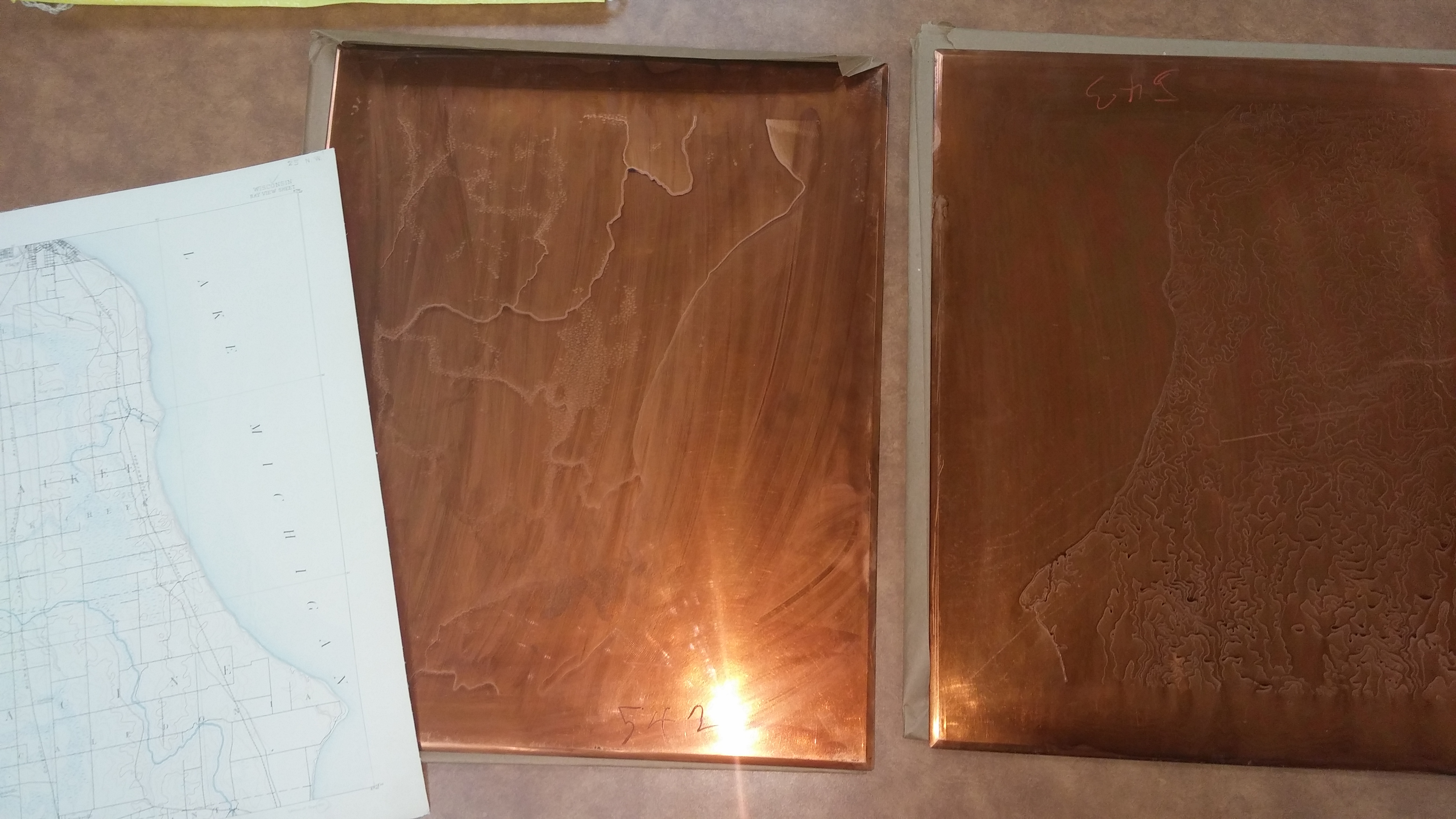
USGS Copper Plates
by Angie Cope
The technology of making maps has changed radically over the years and at the AGS Library, we endeavor to preserve the tools used in that process. In the summer of 2014, the United States Geological Survey made hand engraved copper plates available to libraries and universities via the Federal Surplus system. The plates were used in the engraving of maps and diagrams between 1880s to the 1950s. Three copper plates were used in the construction of each topographic map. Civil divisions and public works were represented in black, water features in blue, and contours and miscellaneous features in brown.
AGSL already owned a Milwaukee 1:62,500 set of plates and now is fortunate enough to add three additional sets to their holdings. The plates acquired this year are for Bayview, Whitewater and Waukesha topographic maps dating from the early 1900s. These will help AGSL, Special Collections and various UWM departments in teaching about history of earth science data collection and compilation, maps and mapping techniques, and engraving and printing techniques.
More pictures of the plates can be seen at the AGS Library Flickr photograph page.
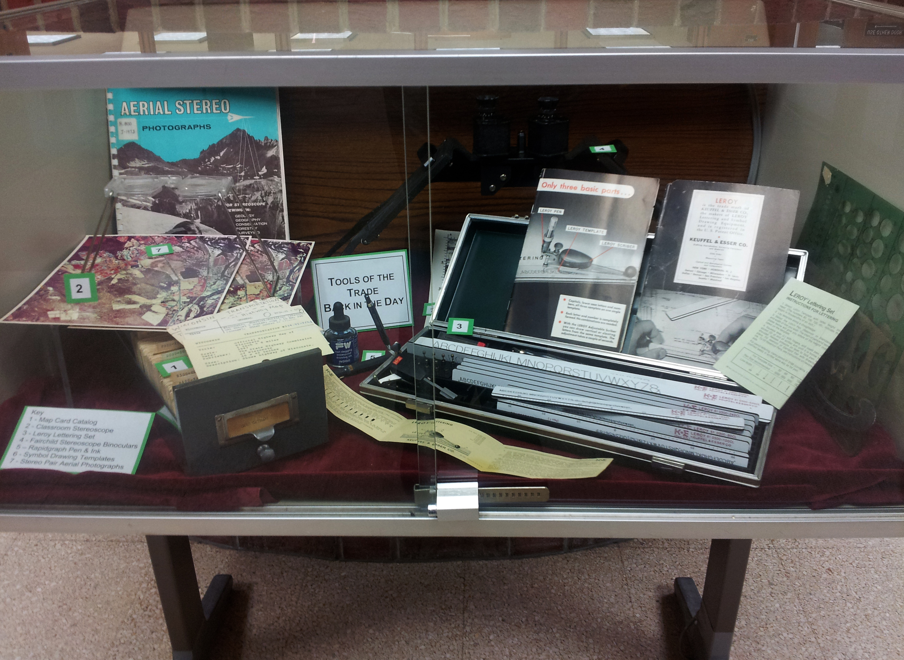
The AGS Library also has a nice exhibit of mid to late 20th century tools used to make a map. Can you identify the Rapidgraph Pen & Ink set, the Leroy Lettering set, the classroom Stereoscope, and the Symbol Drawing Templates?