Looking Back to the Golden Age of Pictorial Map-Making
By Lillian Pachner
Pictorial maps are a unique genre of map that highlights the geographic features of a region with illustrations. These illustrations may be of people, buildings, landmarks, plants, animals, or any number of concepts that can be represented on a map. Besides representational illustrations, these maps often include ornate compass roses, decorative boarders, and intricate cartouches. Often, pictorial maps do not take themselves too seriously, as they regularly have an air of whimsy or humor. Although the focus of a pictorial map is the illustrations, these maps also usually include text which expands on the information presented by the pictures. Pictorial maps are not usually meant to be used for navigational purposes. Rather, they are frequently used to promote tourism, or to commemorate historical events or eras. Many pictorial maps were created for and loved by children given their often brightly colored and stylized illustrations, but they are assuredly not only enjoyed by younger demographics.
By the late eighteenth and early nineteenth centuries, Americans began to view maps differently than they had in the past. Before this era, maps were mostly associated with scientific and navigational tools, despite decorative maps being a very old concept. Soon, maps became associated with the visual arts as well. Maps, of course, never lost their purpose as a tool, so throughout the eighteenth and nineteenth centuries, functionality and aesthetics both became integral factors in map-making. Pictorial maps as we know them today were born out of this intersection of cartographic science and decorative art.
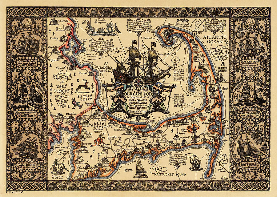
The Golden Age of Pictorial map-making in the United States lasted from about the mid to late 1920s through the 1950s. Some of the “big name” map makers of that time were Jo Mora, Coulton Waugh, Frank Dorn, and Ernest Dudley Chase. Coulton Waugh’s Map of Old Cape Cod, as seen below, is one of the most well-known pictorial maps in America. The works of some of these creators are represented in the AGSL collection.
Pictorial maps truly entered the American mainstream in the 1930s-1950s when both the LA Times and the San Francisco Examiner began dedicating entire pages to pictorial maps made by newspaper staff Charles Hamilton Owens (LA Times) and Howard Burke (San Francisco Examiner). Owens, by far the more prolific of the two artists, reached his peak of popularity during World War II. From February of 1942 through August of 1945, the LA Times published about two-hundred full page pictorial war maps in color, all drawn by Owens. This brought several pictorial maps into the homes and hands of almost every United States citizen.
Although pictorial maps are most often associated with the modern era, they date all the way back to the beginnings of Western cartography. For example, Joan Blaeu’s 1662 World Map has several illustrations representing the Hellenic Pantheon. Early modern cartography utilized an abundance of map decorations, especially in the boarders and margins. These illustrations, while being predecessors to those of the pictorial golden age, serve a different purpose than their modern counterparts. While the illustrations in the pictorial maps play an active role in communicating the purpose and contents of the map, these earlier illustrations are, for the most part, purely decorative. They sometimes have very little relation to the subject of the map that they inhabit. The medieval mappamundi is an early iteration of pictorial map. The oldest and most well-known map in the AGSL collection, the Leardo (below), is a mappamundi. It includes illustrations of landmarks and structures in their approximate locations and has an ornate decorative boarder which consists of the saints’ calendar, and various other illustrations of angelic figures and animals. The Leardo would have been a decorative item, and would not have been a sufficient navigational tool, making it closely related to its modern pictorial successors. One may be familiar with the American Geographical Society’s participation in the #MapMonsterMonday social media trend. Maps with these monsters, while not being pictorial maps as we know them today, have these pictorial elements. These map monsters are the ancestors to the modern pictorial illustration.

Pictorial maps can serve many purposes and represent endless themes. Besides war maps, there are Pictorial maps that tell stories and histories, show locations of tourist traps, and even document fictional journeys. For example, Edward Everett Henry’s 1956 map titled The Voyage of the Pequod from the Book Moby Dick by Herman Melville (below), recounts the narrative from the famous novel. Henry had a predilection for fictional pictorial maps, as he also created the 1960 map, The Virginian: From America’s First “Western” Novel Written by Owen Wister, another map based on a novel. Stephen J. Hornsby is one of the leading experts on pictorial maps, and one of the most prolific authors on the subject. Hornsby says that, while there are things, such as accurate navigation, that a pictorial map commonly does not provide, they include certain elements and themes that a more traditional map cannot such as memory, history, emotion, fun, humor and pride of place/region.

Reading List
“About Pictorial Maps.” George Glazer Gallery Antiques. Accessed December 28, 2022. https://www.georgeglazer.com/wpmain/about-pictorial-maps/.
Brückner, Martin. “Maps, Pictures, and the Cartoral Arts in America.” American Art 29, no. 2 (2015): 2–9. https://doi.org/10.1086/683346.
Cosgrove, Denis. “Maps, Mapping, Modernity: Art and Cartography in the Twentieth Century.” Imago Mundi 57, no. 1 (2005): 35–54. http://www.jstor.org/stable/40233956.
Miller, Greg. “Geography Isn’t Sacred in the Playful World of Pictorial Maps.” Culture. National Geographic, May 3, 2021. https://www.nationalgeographic.com/culture/article/geography-playful-world-pictoral-maps.
Picturing America: The Golden Age of Pictorial Maps. 2017. Video. https://www.loc.gov/item/webcast-7930/.
“The Golden Age of American Pictorial Maps.” The Golden Age of American Pictorial Maps | Osher Map Library. Accessed December 28, 2022. http://oml01.doit.usm.maine.edu/exhibitions/pictorial-maps.
