Maps & America
Looking Back to the Golden Age of Pictorial Map-Making
By Lillian Pachner
Pictorial maps are a unique genre of map that highlights the geographic features of a region with illustrations. These illustrations may be of people, buildings, landmarks, plants, animals, or any number of concepts that can be represented on a map. Besides representational illustrations, these maps often include ornate compass roses, decorative boarders, and intricate cartouches. Often, pictorial maps do not take themselves too seriously, as they regularly have an air of whimsy or humor. Although the focus of a pictorial map is the illustrations, these maps also usually include text which expands on the information presented by the pictures. Pictorial maps are not usually meant to be used for navigational purposes. Rather, they are frequently used to promote tourism, or to commemorate historical events or eras. Many pictorial maps were created for and loved by children given their often brightly colored and stylized illustrations, but they are assuredly not only enjoyed by younger demographics.
By the late eighteenth and early nineteenth centuries, Americans began to view maps differently than they had in the past. Before this era, maps were mostly associated with scientific and navigational tools, despite decorative maps being a very old concept. Soon, maps became associated with the visual arts as well. Maps, of course, never lost their purpose as a tool, so throughout the eighteenth and nineteenth centuries, functionality and aesthetics both became integral factors in map-making. Pictorial maps as we know them today were born out of this intersection of cartographic science and decorative art.
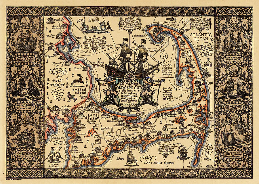
The Golden Age of Pictorial map-making in the United States lasted from about the mid to late 1920s through the 1950s. Some of the “big name” map makers of that time were Jo Mora, Coulton Waugh, Frank Dorn, and Ernest Dudley Chase. Coulton Waugh’s Map of Old Cape Cod, as seen below, is one of the most well-known pictorial maps in America. The works of some of these creators are represented in the AGSL collection.
Pictorial maps truly entered the American mainstream in the 1930s-1950s when both the LA Times and the San Francisco Examiner began dedicating entire pages to pictorial maps made by newspaper staff Charles Hamilton Owens (LA Times) and Howard Burke (San Francisco Examiner). Owens, by far the more prolific of the two artists, reached his peak of popularity during World War II. From February of 1942 through August of 1945, the LA Times published about two-hundred full page pictorial war maps in color, all drawn by Owens. This brought several pictorial maps into the homes and hands of almost every United States citizen.
Although pictorial maps are most often associated with the modern era, they date all the way back to the beginnings of Western cartography. For example, Joan Blaeu’s 1662 World Map has several illustrations representing the Hellenic Pantheon. Early modern cartography utilized an abundance of map decorations, especially in the boarders and margins. These illustrations, while being predecessors to those of the pictorial golden age, serve a different purpose than their modern counterparts. While the illustrations in the pictorial maps play an active role in communicating the purpose and contents of the map, these earlier illustrations are, for the most part, purely decorative. They sometimes have very little relation to the subject of the map that they inhabit. The medieval mappamundi is an early iteration of pictorial map. The oldest and most well-known map in the AGSL collection, the Leardo (below), is a mappamundi. It includes illustrations of landmarks and structures in their approximate locations and has an ornate decorative boarder which consists of the saints’ calendar, and various other illustrations of angelic figures and animals. The Leardo would have been a decorative item, and would not have been a sufficient navigational tool, making it closely related to its modern pictorial successors. One may be familiar with the American Geographical Society’s participation in the #MapMonsterMonday social media trend. Maps with these monsters, while not being pictorial maps as we know them today, have these pictorial elements. These map monsters are the ancestors to the modern pictorial illustration.

Pictorial maps can serve many purposes and represent endless themes. Besides war maps, there are Pictorial maps that tell stories and histories, show locations of tourist traps, and even document fictional journeys. For example, Edward Everett Henry’s 1956 map titled The Voyage of the Pequod from the Book Moby Dick by Herman Melville (below), recounts the narrative from the famous novel. Henry had a predilection for fictional pictorial maps, as he also created the 1960 map, The Virginian: From America’s First “Western” Novel Written by Owen Wister, another map based on a novel. Stephen J. Hornsby is one of the leading experts on pictorial maps, and one of the most prolific authors on the subject. Hornsby says that, while there are things, such as accurate navigation, that a pictorial map commonly does not provide, they include certain elements and themes that a more traditional map cannot such as memory, history, emotion, fun, humor and pride of place/region.

Reading List
“About Pictorial Maps.” George Glazer Gallery Antiques. Accessed December 28, 2022. https://www.georgeglazer.com/wpmain/about-pictorial-maps/.
Brückner, Martin. “Maps, Pictures, and the Cartoral Arts in America.” American Art 29, no. 2 (2015): 2–9. https://doi.org/10.1086/683346.
Cosgrove, Denis. “Maps, Mapping, Modernity: Art and Cartography in the Twentieth Century.” Imago Mundi 57, no. 1 (2005): 35–54. http://www.jstor.org/stable/40233956.
Miller, Greg. “Geography Isn’t Sacred in the Playful World of Pictorial Maps.” Culture. National Geographic, May 3, 2021. https://www.nationalgeographic.com/culture/article/geography-playful-world-pictoral-maps.
Picturing America: The Golden Age of Pictorial Maps. 2017. Video. https://www.loc.gov/item/webcast-7930/.
“The Golden Age of American Pictorial Maps.” The Golden Age of American Pictorial Maps | Osher Map Library. Accessed December 28, 2022. http://oml01.doit.usm.maine.edu/exhibitions/pictorial-maps.
Riding the Rails through Wisconsin
By Lillian Pachner
The beginning of the rail age in North America is marked by the construction of the Baltimore & Ohio Railroad in 1827. Quickly, cities across the young country saw the benefit of being connected by rail. In particular, Milwaukee’s city boosters (people whose job it was to essentially “promote” a city to outsiders), immediately recognized that the emerging national network of railroads would provide local farmers, craftsmen, and manufacturers with access to a larger market. If Wisconsin wanted to keep up with the surrounding cities, it would have to build a railroad.
Wisconsin’s first railroad was the Milwaukee and Mississippi railroad. Construction for this line began in 1847. This railroad was originally called the Milwaukee and Waukesha Railroad. It was the first passenger line to connect Milwaukee with Waukesha. The construction of this railroad was part of the attempt to connect Milwaukee with the Mississippi River. The construction for the second rail line, the Lacrosse and Milwaukee Railroad, began in 1852.
While Milwaukee never became a giant rail-based metropolis like Chicago or St. Louis in the late 1800s, Milwaukee was still able to make its name as a decently large rail-hub. Though the banking crisis of 1857 meant that railroad construction was slow going for a time, banker Alexander Mitchell’s emergence in the industry marked an uptick in Milwaukee’s rail building.
Alexander Mitchell, along with his business partner and mentor George Smith, both Scottish Immigrants, made a large part of their respective fortunes during the Banking Crisis of 1837, twenty years earlier. Mitchell served as secretary for Smith’s company, The Wisconsin Marine and Fire Insurance Company Bank. The company’s insurance charter allowed them to circulate certificates of deposits as if they were currency (these deposit slips were called “George Smith’s Money”), which allowed them to amass a fortune while actual banks were failing. Though the legality of this practice is dubious at best, Mitchell became the wealthiest person in the state by 1860.
Mitchell’s fortune allowed him to supplement and restructure Milwaukee’s existing railroads. He organized the Milwaukee and St. Paul Railway, and other rail construction projects that connected and renamed some of the existing lines. Mitchell’s work helped Milwaukee grow into a hub for wheat shipment in the Midwest. For a time, it rivaled even Chicago on this front.
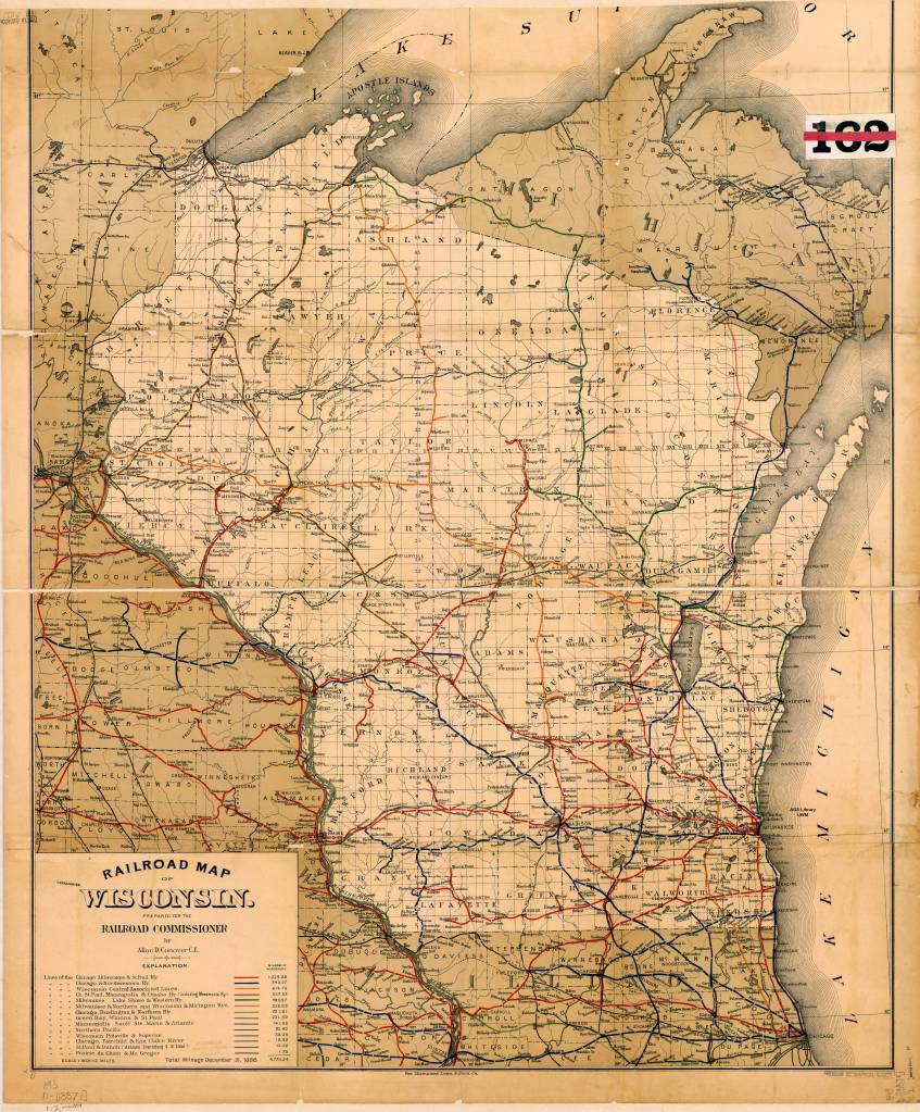
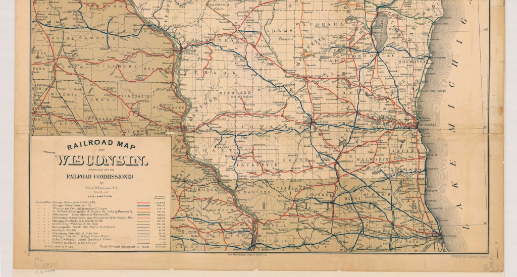
The map above, created by Allan Connover in 1887, (the year of Mitchell’s death) shows the major rail lines going through Wisconsin at the time. This is one of several rail maps available for viewing at the American Geographical Society Library (AGSL) in the Golda Meir Library on Campus. Several of these maps may also be viewed online through the AGSL Digital Collection.
The AGSL is open Monday-Friday, 9 a.m. to 4:30 p.m., on the third floor of the Golda Meir Library at UWM’s campus.
Map Citation:
Connover, D. Allan. Railroad Map of Wisconsin / Prepared for the railroad commissioner by Allan D. Conover C.E. [Map]. 1:760,320. 1 in. = 12 miles. 1887. Link to map on Digital Collection
Sources Cited:
Campbell, Stephen. “Panic of 1837.” The Economic Historian. November 12, 2020
Grant, Roger H. “Railroads”. Encyclopedia of Milwaukee. 2016.
Harding, Bethany. “Alexander Mitchell.” Encyclopedia of Milwaukee. 2016.
Leonard, David Blake. A Biography of Alexander Mitchell 1817-1887. Madison, WI: University of Wisconsin, 1951.
Langill, Ellen. “Banking Industry”, Encyclopedia of Milwaukee. 2016.
Smith, Alice Elizabeth. “George Smith’s Money.” Wisconsin: State Historical Society of Wisconsin, 1966.
Disney’s Darkest Day
By Lauren Maddox
July 17th is celebrated at Disneyland as the park’s official opening day. This year marks the 65th anniversary– Disney hasn’t announced any official celebration plans yet, but fans can most likely expect a birthday bash to remember. The park’s anniversary wasn’t always celebrated on July 17th, however; during Walt Disney’s life, the official date was July 18th, one day after what we consider to be the opening day now.
Walt Disney was adamant that the July 17th opening not be acknowledged as the official opening– and with good reason. July 17th, 1955 was such a disaster that Disney sometimes called it “Black Sunday.”
Expectations for the July 17th preview day were high. Disney had been planning his amusement park since at least 1948, when he sent the first memo to Dick Kelsey describing his plans for a Mickey Mouse theme-park. But the original idea pre-dated even this first draft of the park concept; Disney’s own father worked at the World’s Columbia Exposition in 1893.

Map of the Chicago World’s Fair in 1893. Click the link to see this map in our Digital Collections! 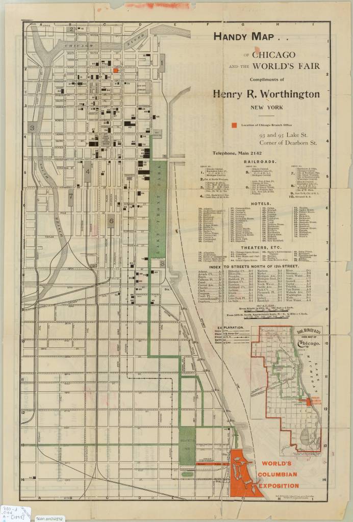
Map of the Chicago World’s Fair in 1893. Click the link to see this map in our Digital Collections!
The World’s Columbia Exposition was a Chicago’s World’s Fair held in 1893 to celebrate the 400th anniversary of Christopher Columbus’s first arrival in North America. The Fair was supposed to be a symbol of the burgeoning ideas of American exceptionalism and Chicago’s recovery from 1871 fire. The Fair was a monumental undertaking; the grounds covered more than 650 acres, and nearly 26 million visitors passed through. More important to Disney’s story than the grandiosity of the fair: the 1893 World’s Fair was the first to host a dedicated amusement park area.
His father’s memories of that Fair and its amusement rides stayed with Disney until his own fatherhood. Disney cited watching his children on a merry-go-round as the final inspiration that lead him to Disneyland.
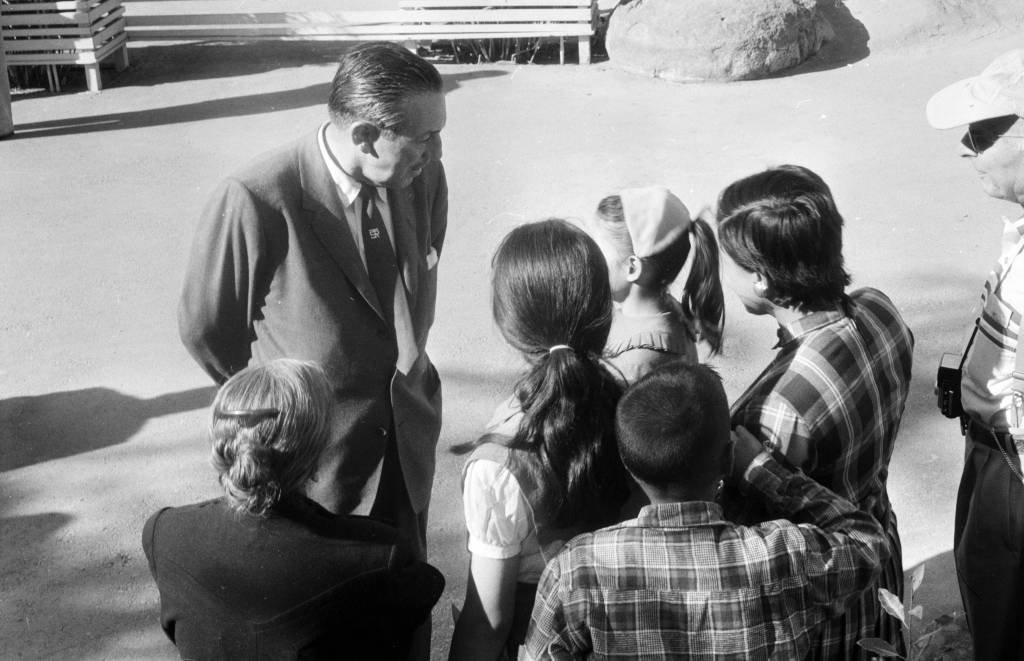
Disney talking to a group of children at Disneyland in 1957. Click the link to see this photo in our Digital Archives!
Besides his tender family memories, Disney also had a practical reason to build an amusement park. He was, after all, a businessman first. As Disney’s animation studio in Burbank gained more success, more and more fans wanted to come visit. The inside of an animation studio isn’t actually that interesting, and it would be hard to get any work done with crowds of tourists peeking in on the animators who worked there.
The original plans for Disneyland put the amusement park right next door to the Burbank studio. After realizing how much of an undertaking (and how many more acres) the amusement park was going to be, Disney moved the location to the Anaheim site.
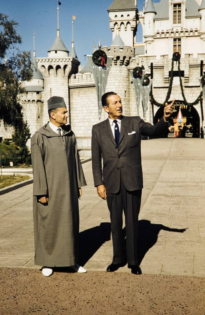
Disney entertaining King Muhammad V at Disneyland, 1957. Click the link to see this photo in our Digital Archives!
For the preview day, Disney invited a select group of 14,000 guests. This included the press as well as friends and families. This was the first thing to go wrong that day. Around twice as many guests actually showed up to the park– many had purchased counterfeit tickets to gain entry to the preview day opening, but many more simply climbed over the walls and broke into the park. Disneyland, for the day, was only prepared to serve the 14,000 intended guests; vendors ran out of food, half of the water fountains weren’t functioning because the plumbers working on the park went on strike (and offered the ultimatum “bathrooms or water fountains”). The event was sponsored by Pepsi, so many park-goers accused Disney of forcing them to buy drinks by sabotaging the water fountains. It was an unseasonably warm day for Anaheim, and the freshly poured asphalt was so soft that women’s high heels would sink into it.
Besides these critical logistical failures, the media coverage of the event was a circus. Disney himself missed the cue to read his dedication, and said, to the camera live and on air, that he’d thought he’d been given the signal to start. Bob Cummings was caught on camera flirting with the dancers and even kissing one girl. Other commentators lost their mics and had to cover for themselves while the tapes ran on.
In summary, the whole day was deeply embarrassing to Disney. He never acknowledged the July 17th preview as the opening day of Disneyland, and it was only after his death that it was adopted as the official anniversary.
Disney’s legacy lives on, for all the good and ills that entails. But perhaps his greatest contribution to the amusement park circuit, besides Disneyland itself, is the impact his choices made on amusement park cartography.
When Disney was first pitching the park idea to investors, he used maps created by Herbert Ryman to help draw the picture of the park that he was imagining and struggling to put into words. Ryman’s version of the park didn’t make it to brochures, partially because his maps were of an imaginary park that wasn’t quite the same as the real Disneyland.
The 1953 Ryman Map of Disneyland from the New York Times. Click the link to see the rest of this article!
Due to budgeting issues, the official map of Disneyland took another three years after opening day to create. Sam McKim was the artist behind the first official park maps in 1958. The maps, at this point, still had some aspirations for parts of Disneyland not yet built, but mostly functioned as tools for park-goers to use to find their way around and as free souvenirs they could take home. Sam McKim’s maps ran, with some slight adjustments over the years, until 1964. For his contributions to the Disney brand, he was named “Map Maker to the Kingdom” and a tribute to his work can still be found at Disneyland.
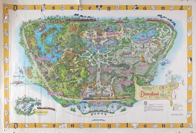
McKim’s 1958 Map of Disneyland. Click the link to see this map on Mouse Maps!
Maps as souvenirs was not a new concept; many World’s Fairs gave out artful brochure maps for visitors to remember their day at the Fair. But McKim’s willingness to push the boundaries of realistic map making in order to appeal to the imaginative and exciting nature of Disneyland revolutionized the amusement park map. After McKim, the artists behind the brochure maps became anonymous, but his impact on the work remains clear.
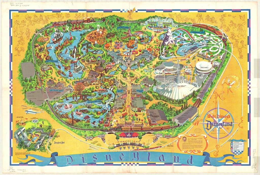
1968 Map of Disneyland. This version removed Edison Square and Liberty Park, which were not built but still included on the previous generation of maps. Click the link to see this map in our Digital Collections!
Cartography was a key tool in Disneyland’s creation. And it continues to be an important part of the Disneyland brand an experience– but more than that, the maps at Disneyland give us a way to take the park home. That first day may have been a disaster, but many, many Disney fans have experienced and loved the park since then. Happy 65th anniversary! Remember to take a map before you go–they help us find our way.
How Does Your Garden Grow? Imagining the Cemetery
By Lauren Maddox
As Halloween comes and goes, our minds drift to the dark and the macabre–we can’t help but think about spooky skeletons, werewolves, witches, ghosts, and vampires or about what those figures really represent to us: death. Death isn’t something people like to think about very much. America, in particular, has always held death at arms length with only squeamish acknowledgement.
The Church began to regulate burials around the 7th century across Europe–rituals for the dead and dying became increasingly Christian, and burying bodies in consecrated ground became an important tenant for dealing with the dead. In these early days of Christian burial, bodies were buried in mass graves so that the bones could be exhumed and stored in ossuaries in the walls of the church. But, due to lack of space, eventually bodies began to be buried in the church yard. Graves would be marked with simple stones, or is some cases, wooden crosses, unless the family was able to afford a more complicated memorial for their loved ones.
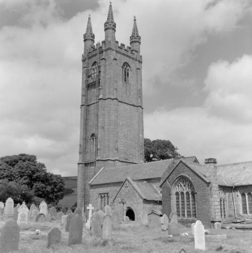
St. Pancras Church in Widecombe-in-the-Moor, England from the Clarence W. Sorenson Collection. Click the link to see this photo in our Digital Collections!
The churchyard grave was thought to be a place under the protection of the Church– it was a safe place where loved ones could be guaranteed to pass into an easy afterlife. But as populations boomed and the Industrial Revolution’s dangerous growth and unadulterated industry began to accumulate a body count, the ideation of the churchyard began to change. Instead of being a place where one might visit their loved ones and feel comforted by their presence, they became places in which disease festered and spread. Floods would unearth the recently buried and rain that passed through the churchyard might become contaminated. The proximity of the churchyard burial ceased to be a comfort and became a source of anxiety too-close-to-home.
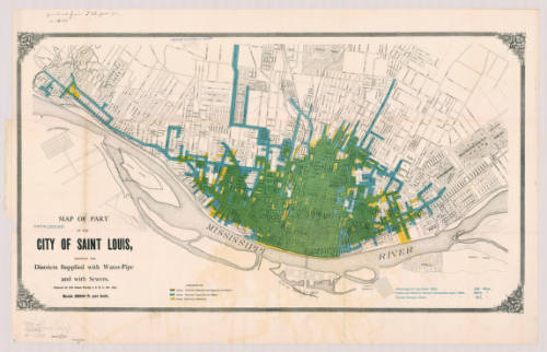
Map of St. Louis, MI in 1884. Click the link to see this map in our Digital Collections! 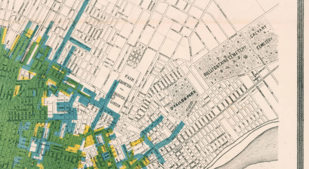
Detail from 1884 Map of St. Louis featuring the Bellefontaine Cemetery and the Calvary Cemetery.
Because of this, in the 19th century, the cemetery moved out of town. Death was an upsetting reality to have in your backyard for Americans, so cemeteries were moved away from the populated areas of the city and from the water supplies for the city. And, in a final symbolic gesture, cemeteries were gated to show that they were no longer part of the world of the living. Looking at these two late 19th century maps of St. Louis and Philadelphia, you can see how far out of town the cemeteries were moved for the safety and peace of mind of the living.
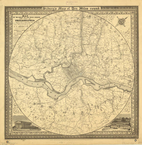
1847 Map of Philadelphia including multiple cemeteries. Click the link to see this map in our Digital Collections!
But, ironically, the cemetery also became like a public park. According to Keith Eggener, author of Cemeteries, cemeteries were free oases where people could escape the hustle and bustle of their city lives. People would bring picnics, bicycles, take strolls, and use the cemetery as a brief respite from daily life. They became immensely beautified– the cemetery was not only important as a place that separated the dead from the living, but also as a place that the living could visit at their leisure and leave again when they were satisfied.
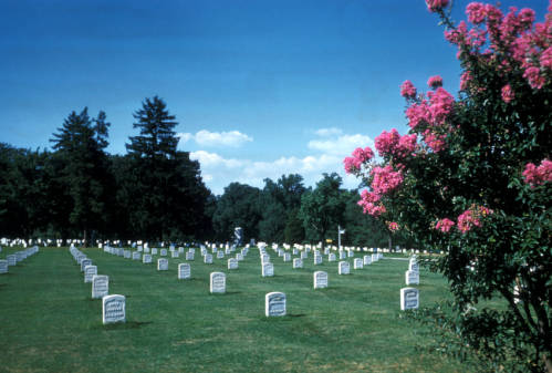
Arlington National Cemetery from the Harrison Forman Collection. Click the link to see this photo in our Digital Collections!
We might be a little more comfortable with our cemeteries these days, but they’re still not going to be our ideal afternoon spot. But during Halloween season, when death is on our minds, it’s important to remember our relationship to the place where spooky skeletons and vampires reside. And maybe accept that those scary figures are pretty harmless– Savannah’s Bonaventure Cemetery is a beloved tourist destination, where people go to see the beautiful parks. But, remember– always “keep your distance, remain quiet and show respect for the dead.”
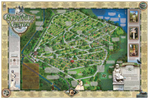
Illustrated Map of Bonaventure Cemetery in Savannah Georgia, 2016. Click the link to see this map in our Digital Collections! 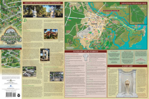
History of Bonaventure and Additional Information.
Hispanic Heritage Month: A Special Pop-Up Exhibit
By Lauren Maddox
This past Sunday marked the beginning of National Hispanic Heritage Month. This month is a celebration of Hispanic Americans who, according to the National Hispanic Heritage Month website, “have positively influenced and enriched our nation and society.” The tradition of a National Hispanic Heritage Month began in 1968, when Representative Edward R. Roybal sponsored legislation that would establish a National Hispanic Heritage Week. The holiday week was signed into effect under Lyndon B. Johnson and then expanded to a month-long period during Reagan’s presidency in 1988. The original start date, September 15th, was chosen to celebrate the official independence days of Costa Rica, El Salvador, Guatemala, Honduras, and Nicaragua declared in 1821. The original week also encompassed Mexico, Belize, and Chile’s independence days. Now the month-long observance, celebrated from September 15th-October 15th, includes all of these days as well as Dia de la Raza.
In honor of National Hispanic Heritage Month, many organizations including the Library of Congress, the National Gallery of Art, the Smithsonian, and the National Park Service are hosting events throughout September and October. Throughout the month, there will be a Community Day, a Hispanic Heritage Month Concert with Inca Son, a book talk with Haitian-American writer Edwidge Danticat, and a Wikipedia Edit-a-thon and more. And in addition to the live events, many digital archive collections are being made public this month– the National Hispanic Heritage Month website includes a list of all related exhibits and collections here. Some highlights from this list: the Library of Congress’s Archive of Hispanic Literature on Tape, Documents of 20th Century Latin American and Latino Art supported and hosted by the National Endowment for the Humanities, and many, many others.
But these aren’t the only ways to celebrate National Hispanic Heritage Month! This week from September 25-27th, the AGSL and UWM Archives are collaborating on a pop-up exhibit featuring curated pieces from both libraries’ collections. The exhibit will span both of our libraries: materials from the Archives will be on display on the second floor and maps from our collections will be exhibited in the AGSL. We are especially excited to showcase the Tira de Santa Catarina Ixtepeji scroll. Please, come celebrate this historic month with us! And enjoy a preview of some of the maps included in the exhibit:
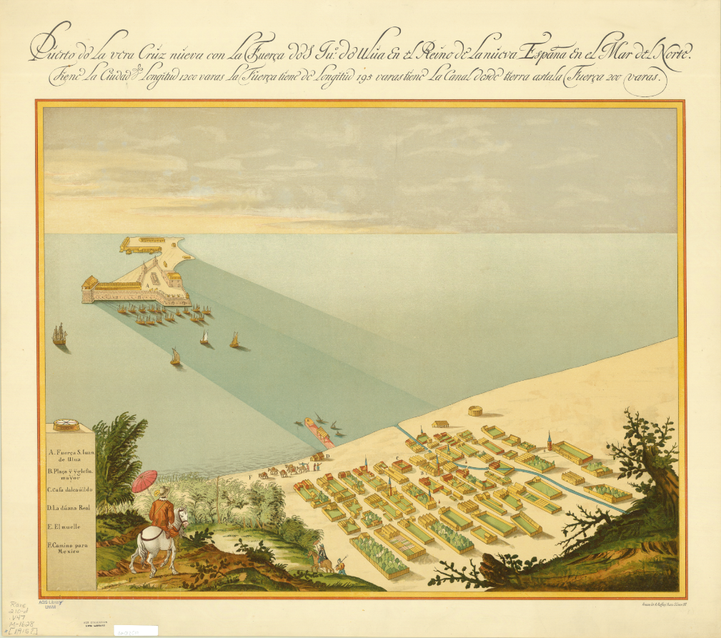
Map of San Juan Ulua Island in 1628. 
Fascimile of 1468 World Map, previously owned by the Hispanic Society of America. 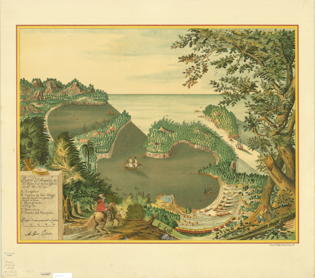
Map of Acapulco in 1628. 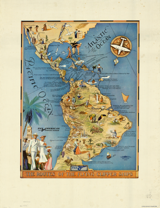
“The Routes of the Flying Clipper Ships,” 1930s. Click the links to see these maps in our Digital Collections!
The AGSL is open from 8:30-4:30 Monday-Friday! We will also be participating in Milwaukee Open Doors this weekend on September 28th from 10-5! Please stop by and see us!
The Island of California
By Lauren Maddox
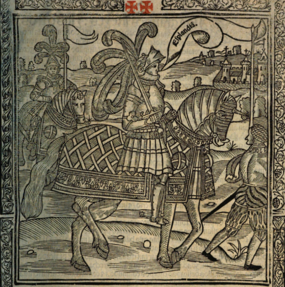
Illustration from La sergas de Esplandián
“Know that, on the right hand of the Indies, there is an island called California, very near to the Terrestrial Paradise;” this description, found in Chapter 157 of Las sergas de Esplandián, names a California at least sixteen years before Cortez spotted the coast of the land he would name California. The Spanish romance, which was a sequel to Garci Rodríguez de Montalvo’s better-known and better-received Amadis de Gaula, was largely forgotten despite being the first mention of a place named California. Esplandián was considered an inferior sequel and faded into insignificance; it’s greatest claim to fame is its brief appearance in Don Quixote’s library in Cervantes’s comical romance. And even that reference was unflattering. The curate chose to burn Esplandián instead of Amadis de Gaula because, he said, we should not “spare the son for the virtues of the father.”
So, Las sergas de Esplandián was a failed romance that was quickly forgotten. But, as the first recorded use of California, it stands to reason that this forgettable Spanish romance could have inspired Cortez when he encountered the lowest tip of the Baja California Peninsula, 775 miles from where the peninsula joins the mainland. As far as Coretz could tell from his ship, he had found an island on the right hand of the Indies, very near to the Terrestrial Paradise.
The misconception that California was an island would persist throughout the 16th century, and resurface with new, incorrect maps released in the 17th and 18th century. In 1539, Cortez’s navigator Francisco de Ullou ventured northward into California and discovered it was a peninsula, debunking the theory that California was an island just six years after the first sighting of the peninsula. Somehow, the legend persisted despite fairly correct representations of the peninsula being published as early as 1569.
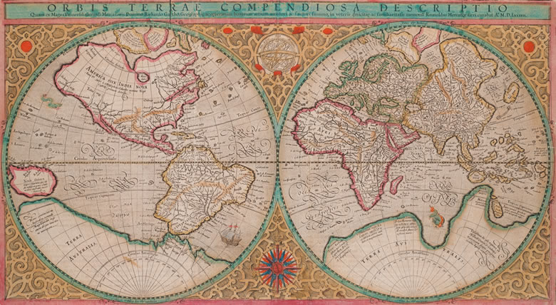
Mercator’s 1569 edition of Orbis terrae compendiosa descriptio from Envisioning the World: The First Printed Maps 1472-1700 Click the link to see this map in our Digital Collections
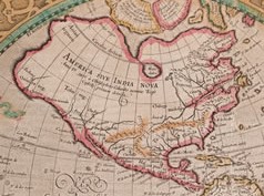
America in the Mercator Map
Many cartographers incorporated Ullou’s discovery of the peninsula into their maps, including this 1569 world map by Gerard Mercator. If you look closely at America, you can see the Baja California Peninsula clearly and correctly attached to the mainland. This representation wouldn’t stick–the Baja California Peninsula would be confused for an island again after Juan de Fuca’s voyage at the turn of the century. In 1592, de Fuca claimed to have found a strait he thought could be the Northwest Passage with a large island at its mouth. Only one account of this discovery survived, and the location of de Fuca’s strait was confused with California, reviving the representation of California as an Island.
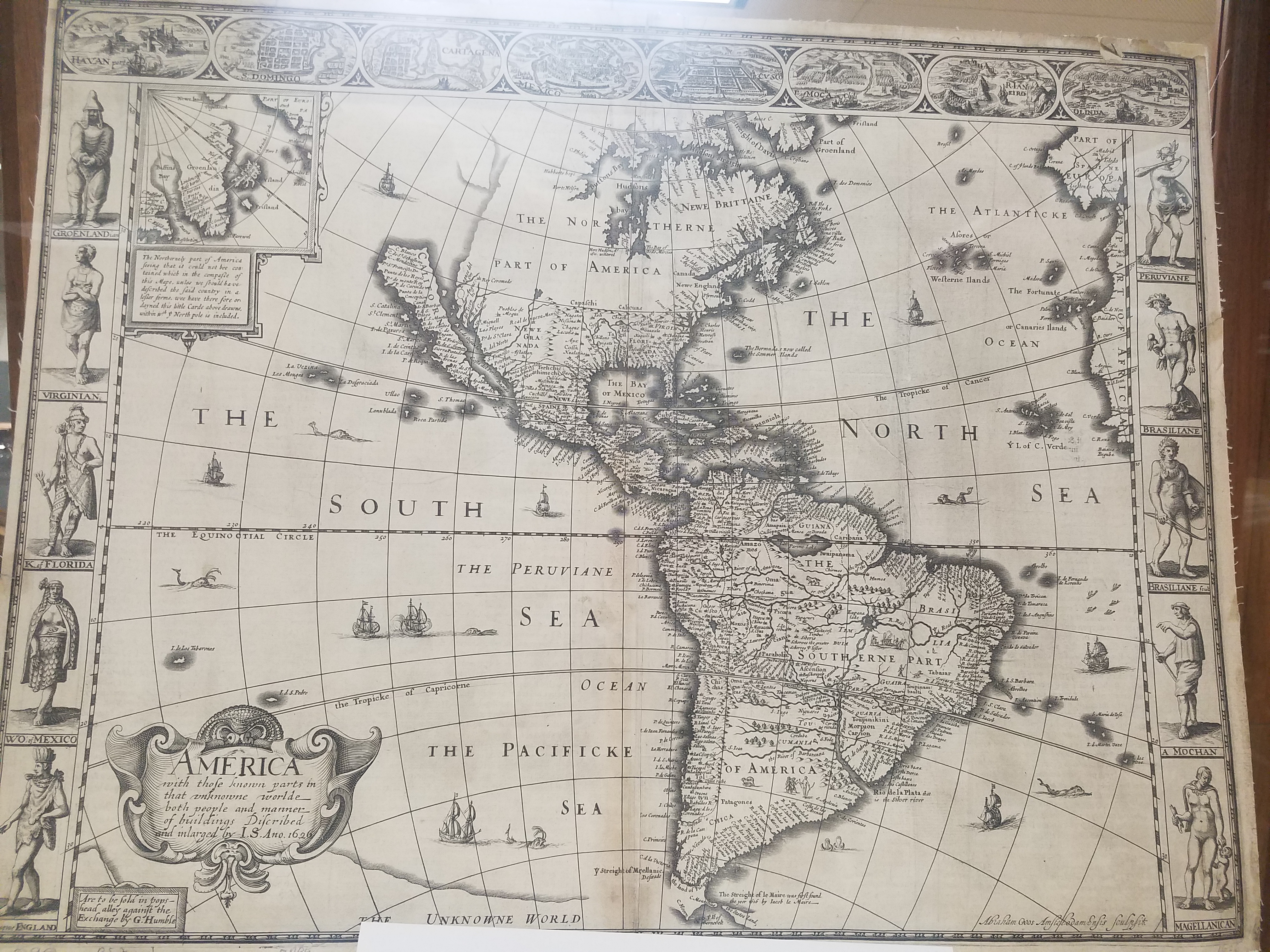
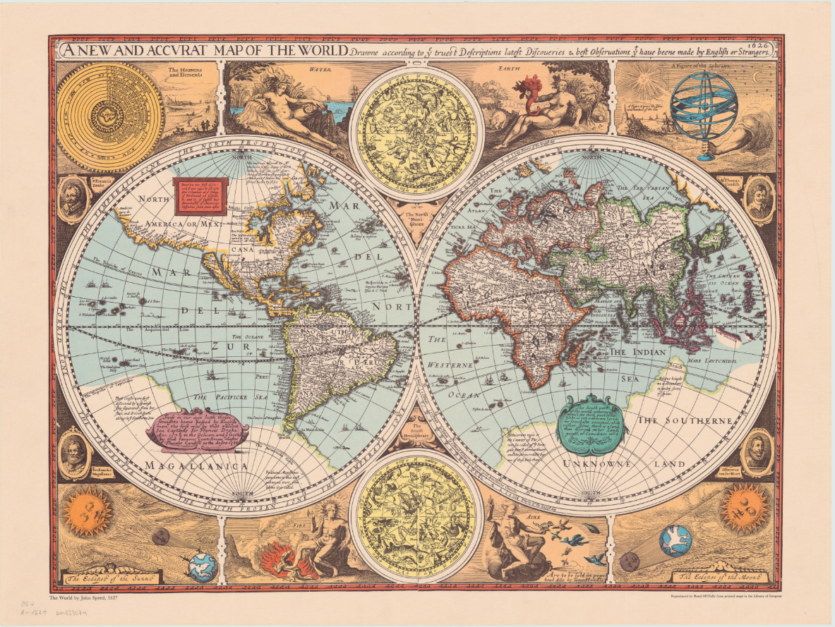
An overland expedition in 1602-1604 should have disproved de Fuca’s claim to have found a Northwest Passage, or at least cleared up any confusion about whether the Baja California Peninsula was the island he had claimed to see at the mouth of the strait. Despite Juan de Onate’s reports, the northern terminus of the Gulf of California was left vague on maps by the Spanish so that Cortez’s claim to the territory in 1533 could invalidate Drake’s later claim in 1579. Several maps released after Mercator’s map and de Onate’s reports show the peninsula detached from the mainland. One of the first atlas maps to depict California as an island was English mapmaker and historian John Speed’s America with those Known Parts in that Unknowne World both People and Manner of Building from 1626 or 27. This representation of America, seen again his A new and accurat map of the world reproduced by Randy McNally in 1966, also includes a fairly accurate mapping of the United States’ East Coast.
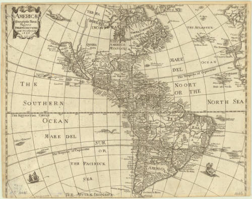
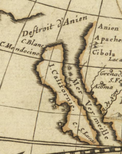
William Trevethen’s 1666 Americ descriptio nova depicts the Island of California once again. The Trevethen map also places Sir Francis Drake’s Nova Albion on the island; Nova Albion was actually a part of continental Mexico, and the English claim to Nova Albion was their foothold into claiming further continental territory, which is why the Spanish worked so hard to invalidate that claim. Nova Albion is now Point Reyes, which is just Northwest of the San Francisco area. The region North of the Island of California is marked “terra incognita” with a sea monster lurking in the waters to indicate the unknown and unexplored continent.
Click the link to see the Americ descriptio nova 1666, published in 1670 edition of Peter Heylyn’s Cosmography in our Digital Collections
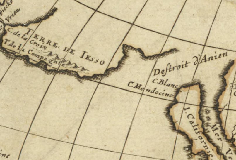
A 1677 world map in the AGSL collection by Pierre Duval includes the Island of California at the mouth of an approximately placed strait. This map also includes a vague coast line marked “terre de Iaso” just Northwest of California. The “terre de Iaso” was thought to be a region where Japan connected to North America.
L’America Settentrionale, another 1677 map by Guillaume Sanson, leaves the unexplored areas of North America blank to indicate the unknown, but clearly includes the island of California. Remarkably, the French maps do not include Nova Albion.
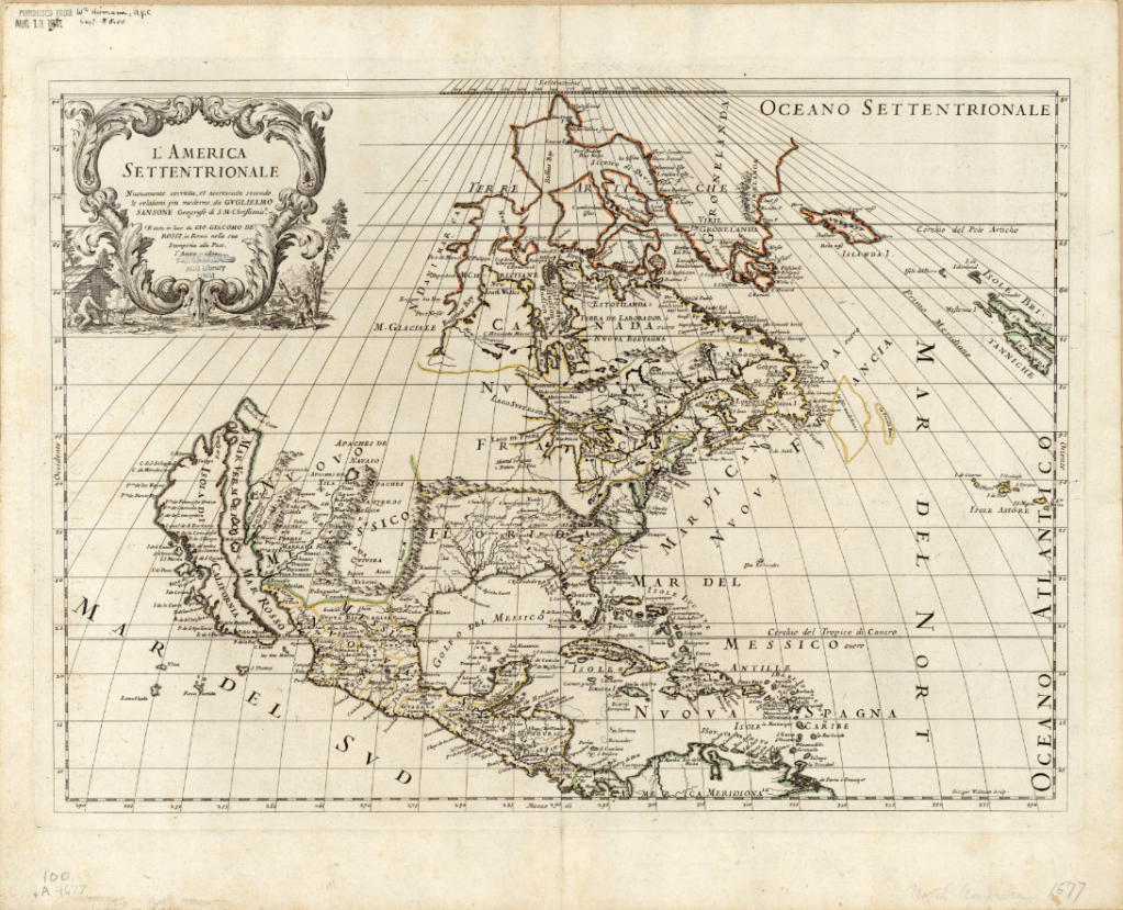
Click the link to see Guillaume Sanson’s 1677 Map of America in our Digital Collections
At the end of the 16th century, Dutch cartographers Gerard and Leonard Valck produced another map depicting California as an island. The Valck map, like the 1677 Duval map, includes a reference to an area connecting North America and Asia. On the Valck map, it is referred to as the “Terra Esonis.” The Valcks only include the vague coastline of the fabled connection, leaving a blank space– perhaps to leave room for future discoveries. The map includes detailed records of place names and waterways, as well as an illustrated cartouche depicting a pair of “Americans” surrounded by bountiful crops and exotic animals.
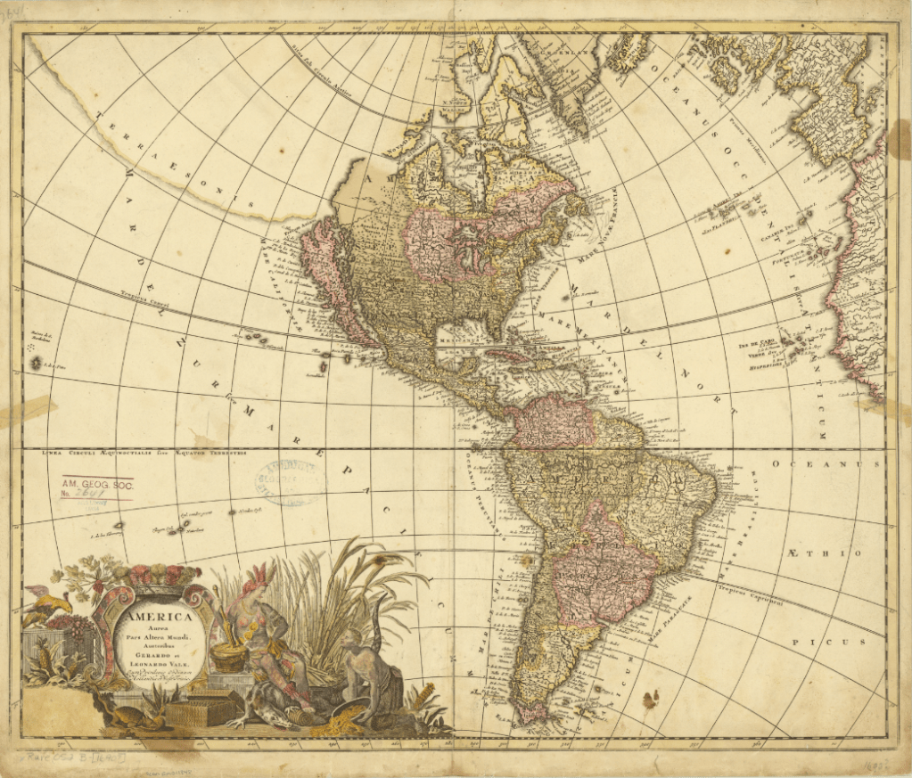
Click the link to see the Valcks’ 1690 Map of America in our Digital Collections
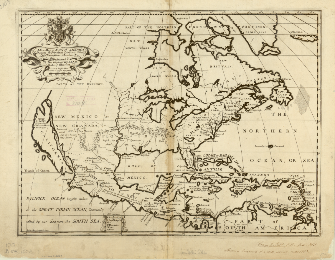
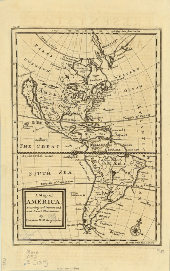
This map was produced just eight years before Eusebio Francisco Kino’s series of overland expeditions, which would finally confirm that the Baja California Peninsula was indeed a peninsula. Kino, a Jesuit missionary and cartographer, believed that California was an island until he began to explore deeper into the continent. He initially intended to establish a route between Jesuit missions in Sonoran and Baja California on his expeditions from 1698-1706, but also reported and confirmed the land connection and reestablished the existence of the Baja California Peninsula. The Jesuit order generally accepted his claims, but Europeans were slow to incorporate the peninsula into their own maps because of conflicting reports from Juan Mateo Manje, who joined Kino on several expeditions. Maps created into the 18th century by Europeans still recorded the Island of California’s existence; these two English maps were created just a few years after Kino’s final confirmation of the peninsula’s land connection. The first map, Michael Burgher’s 1714 A New Map of North America, depicts the topography of the area, as well as records of new discoveries, settlements, and claimed and unclaimed territory. The 1717 Map of America by Herman Moll has a similar focus, but includes South America.
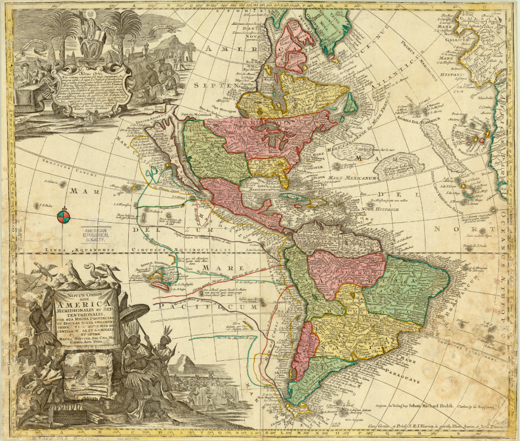
The latest map in the AGSL collection depicting California as an island is Matthaeus Seutter’s 1740 map. The hand-colored map is filled with notes and ship routes, as well as two detailed cartouches depicting local peoples and their conversion to Christianity. Seutter’s map also references an Ocean of California surrounding the island and several sketches of aquatic plants.
Click the link to see the 1740 Seutter Map in our Digital Collections
Montalvo’s lost romance tells stories of a bountiful and fertile island ruled by women adorned in gold and jewels, and the Queen Calafia who fell in love with a Spanish man and forfeited her power, treasures, and land to their king for the chance to marry him. In Las sergas de Esplandián, the island of California is full of potential coveted by conquering Europeans. In many ways, this fiction became reality– California became an island, first by misconception, and then deception as the Spanish maneuvered to maintain their claim on the land and prevent English settlement. And in our collections, we have 200 years of maps recording one of cartography’s longest-lived errors.
18th Century Missional Maps in the Amazon Basin Exhibit at the AGS Library
April 26th was the Maps & America lecture sponsored by Arthur and Jan Holzheimer. The speaker was Dr. Carme Montaner, Head, Unitat Cartoteca de Catalunya, Institut Cartogràfic i Geològic de Catalunya, Barcelona. Her talk “18th Century Missional Maps in the Amazon Basin: The Case of Ocapa Monastery in Peru” was accompanied by an exhibit of materials from the AGS Library as curated by Jovanka Ristic.
Here are photos from the exhibit. Click on any image to open a larger view.


Posted by Angie Cope
