World’s Fair
Disney’s Darkest Day
By Lauren Maddox
July 17th is celebrated at Disneyland as the park’s official opening day. This year marks the 65th anniversary– Disney hasn’t announced any official celebration plans yet, but fans can most likely expect a birthday bash to remember. The park’s anniversary wasn’t always celebrated on July 17th, however; during Walt Disney’s life, the official date was July 18th, one day after what we consider to be the opening day now.
Walt Disney was adamant that the July 17th opening not be acknowledged as the official opening– and with good reason. July 17th, 1955 was such a disaster that Disney sometimes called it “Black Sunday.”
Expectations for the July 17th preview day were high. Disney had been planning his amusement park since at least 1948, when he sent the first memo to Dick Kelsey describing his plans for a Mickey Mouse theme-park. But the original idea pre-dated even this first draft of the park concept; Disney’s own father worked at the World’s Columbia Exposition in 1893.

Map of the Chicago World’s Fair in 1893. Click the link to see this map in our Digital Collections! 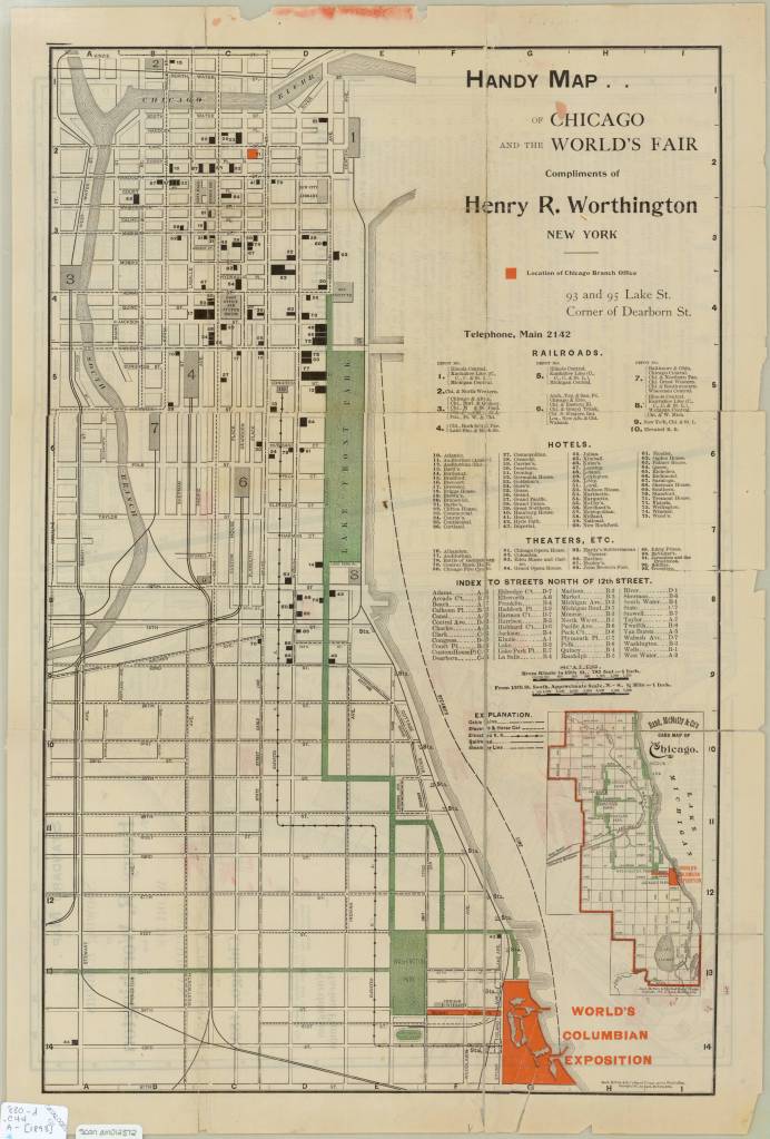
Map of the Chicago World’s Fair in 1893. Click the link to see this map in our Digital Collections!
The World’s Columbia Exposition was a Chicago’s World’s Fair held in 1893 to celebrate the 400th anniversary of Christopher Columbus’s first arrival in North America. The Fair was supposed to be a symbol of the burgeoning ideas of American exceptionalism and Chicago’s recovery from 1871 fire. The Fair was a monumental undertaking; the grounds covered more than 650 acres, and nearly 26 million visitors passed through. More important to Disney’s story than the grandiosity of the fair: the 1893 World’s Fair was the first to host a dedicated amusement park area.
His father’s memories of that Fair and its amusement rides stayed with Disney until his own fatherhood. Disney cited watching his children on a merry-go-round as the final inspiration that lead him to Disneyland.
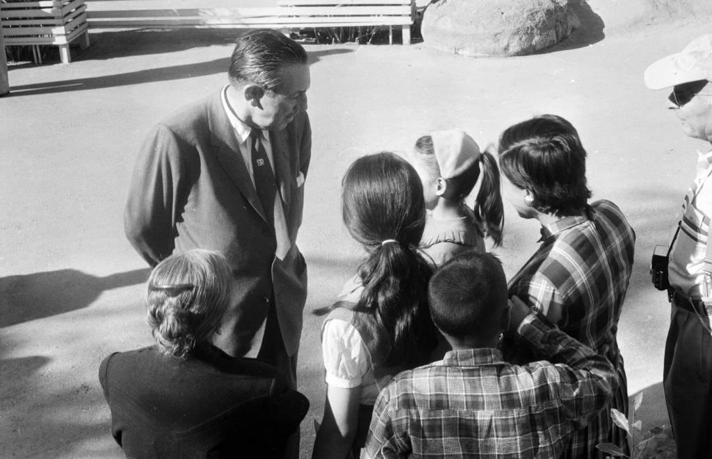
Disney talking to a group of children at Disneyland in 1957. Click the link to see this photo in our Digital Archives!
Besides his tender family memories, Disney also had a practical reason to build an amusement park. He was, after all, a businessman first. As Disney’s animation studio in Burbank gained more success, more and more fans wanted to come visit. The inside of an animation studio isn’t actually that interesting, and it would be hard to get any work done with crowds of tourists peeking in on the animators who worked there.
The original plans for Disneyland put the amusement park right next door to the Burbank studio. After realizing how much of an undertaking (and how many more acres) the amusement park was going to be, Disney moved the location to the Anaheim site.
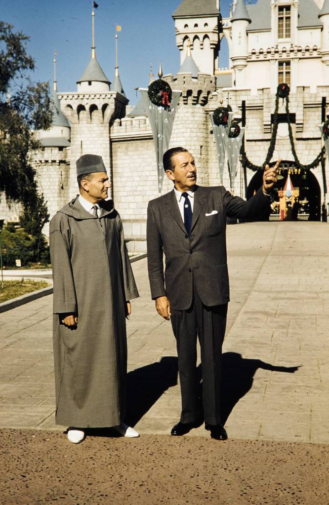
Disney entertaining King Muhammad V at Disneyland, 1957. Click the link to see this photo in our Digital Archives!
For the preview day, Disney invited a select group of 14,000 guests. This included the press as well as friends and families. This was the first thing to go wrong that day. Around twice as many guests actually showed up to the park– many had purchased counterfeit tickets to gain entry to the preview day opening, but many more simply climbed over the walls and broke into the park. Disneyland, for the day, was only prepared to serve the 14,000 intended guests; vendors ran out of food, half of the water fountains weren’t functioning because the plumbers working on the park went on strike (and offered the ultimatum “bathrooms or water fountains”). The event was sponsored by Pepsi, so many park-goers accused Disney of forcing them to buy drinks by sabotaging the water fountains. It was an unseasonably warm day for Anaheim, and the freshly poured asphalt was so soft that women’s high heels would sink into it.
Besides these critical logistical failures, the media coverage of the event was a circus. Disney himself missed the cue to read his dedication, and said, to the camera live and on air, that he’d thought he’d been given the signal to start. Bob Cummings was caught on camera flirting with the dancers and even kissing one girl. Other commentators lost their mics and had to cover for themselves while the tapes ran on.
In summary, the whole day was deeply embarrassing to Disney. He never acknowledged the July 17th preview as the opening day of Disneyland, and it was only after his death that it was adopted as the official anniversary.
Disney’s legacy lives on, for all the good and ills that entails. But perhaps his greatest contribution to the amusement park circuit, besides Disneyland itself, is the impact his choices made on amusement park cartography.
When Disney was first pitching the park idea to investors, he used maps created by Herbert Ryman to help draw the picture of the park that he was imagining and struggling to put into words. Ryman’s version of the park didn’t make it to brochures, partially because his maps were of an imaginary park that wasn’t quite the same as the real Disneyland.
The 1953 Ryman Map of Disneyland from the New York Times. Click the link to see the rest of this article!
Due to budgeting issues, the official map of Disneyland took another three years after opening day to create. Sam McKim was the artist behind the first official park maps in 1958. The maps, at this point, still had some aspirations for parts of Disneyland not yet built, but mostly functioned as tools for park-goers to use to find their way around and as free souvenirs they could take home. Sam McKim’s maps ran, with some slight adjustments over the years, until 1964. For his contributions to the Disney brand, he was named “Map Maker to the Kingdom” and a tribute to his work can still be found at Disneyland.
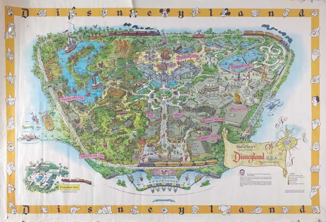
McKim’s 1958 Map of Disneyland. Click the link to see this map on Mouse Maps!
Maps as souvenirs was not a new concept; many World’s Fairs gave out artful brochure maps for visitors to remember their day at the Fair. But McKim’s willingness to push the boundaries of realistic map making in order to appeal to the imaginative and exciting nature of Disneyland revolutionized the amusement park map. After McKim, the artists behind the brochure maps became anonymous, but his impact on the work remains clear.
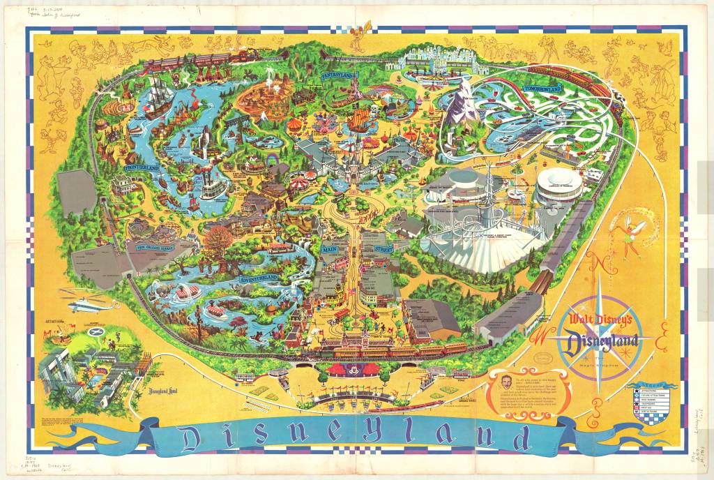
1968 Map of Disneyland. This version removed Edison Square and Liberty Park, which were not built but still included on the previous generation of maps. Click the link to see this map in our Digital Collections!
Cartography was a key tool in Disneyland’s creation. And it continues to be an important part of the Disneyland brand an experience– but more than that, the maps at Disneyland give us a way to take the park home. That first day may have been a disaster, but many, many Disney fans have experienced and loved the park since then. Happy 65th anniversary! Remember to take a map before you go–they help us find our way.
Fair and Square: A Short History of World’s Fairs
By Lauren Maddox
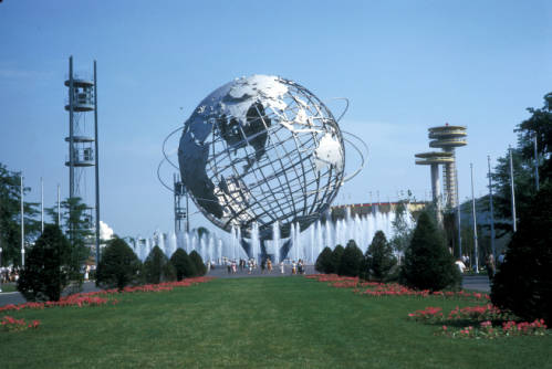
Unisphere Sculpture from 1964 New York World’s Fair, Taken by Harold Mayer. Click the link to see this photo in our Digital Collections!
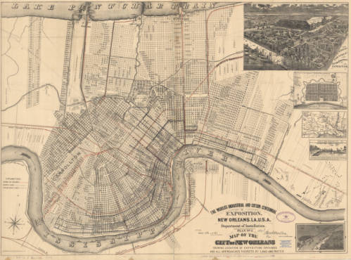
1884 Map of New Orleans’ Exposition Grounds. Click the link to see this map in our Digital Collections!
In 1984, Louisiana hosted a World’s Fair celebrating “The World of Rivers.” It was the last World’s Fair in the U.S. And it was the most financially disastrous fair in the history of World’s Fairs. To be fair, the point of hosting World’s Fairs and Expositions was never to make money– most host countries had to shell out exorbitant amounts of money to finance their fairs. But the point of the World’s Fair was never to make money; instead, these fairs were celebrations of progress and a chance to impress the international community. Host countries never expect to make a profit off of the Fair, but the 1984 Fair was particularly draining– it was the only Fair to ever go bankrupt.
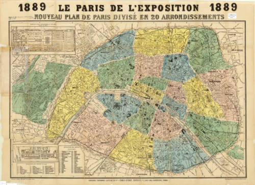
Map of Paris for the 1889 Exposition. Click the link to see this map in our Digital Collections!
But before the 1984 fair, the U.S. had a rich history as a member of the International Bureau of Exhibitions– they’ve hosted 30 World’s Fairs since their first in 1829. And before that?
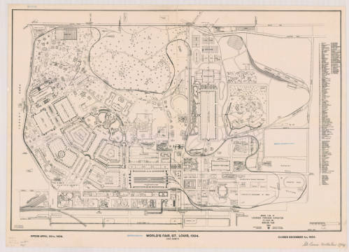
Ground Plan of Louisiana Purchase Exposition, 1904. Click the link to see this map in our Digital Collections!
The tradition of the World’s Fair is based heavily on French national expositions– but the first was actually hosted in Prague in 1791. This exposition was before World’s Fairs were standardized and regulated by the Bureau of International Expositions. These early expositions had their roots in Medieval festivals, and quickly became a way for post-revolution France to unite their new republic. The industry-focused expos continued under Napoleon but still focused on French products.
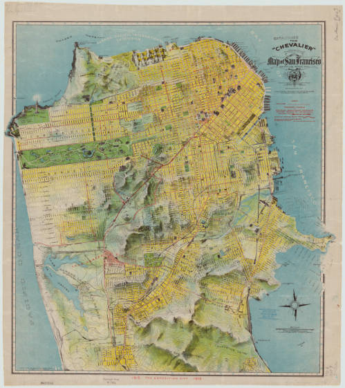
1912 Chevalier Map of San Francisco featuring the Panama-Pacific International Exposition grounds. Click the link to see this map in our Digital Collections!
The exposition most commonly cited as the first international affair is London’s Great Exposition in 1851. This World’s Fair was iconic– its great Crystal Palace became the symbol of World’s Fairs for years to come and continues to be one of the most quintessential Victorian structures.
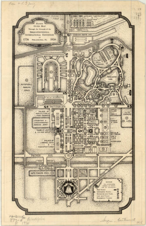
Complimentary Map of the Sesqui-Centennial International Exposition at Philadelphia, PA, 1926. Click the link to see this map in our Digital Collections! 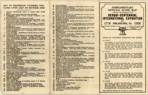
Points of Interest at the Sesqui-Centennial International Exposition at Philadelphia. Click the link to see this map in our Digital Collections!
In 1928, the Bureau of International Expositions (Bureau international des expositions) was established in order to oversee and approve of expo arrangements internationally and to set standards for expositions across nations. 170 countries are currently members of the BIE– including the United States. The BIE has remained in charge of international expositions ever since.
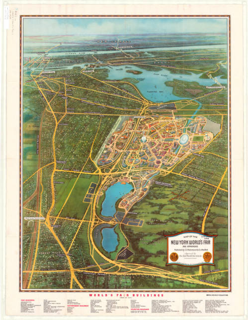
Map of the New York World’s Fair with Map of Greater New York’s Transit, 1939. Click the link to see this map in our Digital Collections! 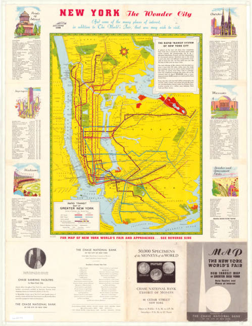
Map of New York Transit System with Points of Interest in the City, 1939. Click the link to see this map in our Digital Collections!
The nature of World’s Fairs have changed drastically since their Medieval beginnings– these fairs began as a way to unite communities, national and international, and then became an opportunity for countries to showcase their industrial prowess and establish themselves on the global stage.
Map of Chicago’s 1933 World’s Fair. Click the link to see this map in our Digital Collections! 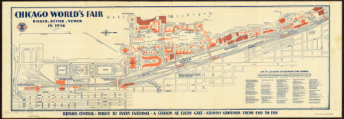
Map of Chicago’s 1934 World’s Fair. Click the link to see this map in our Digital Collections!
The 1984 exposition signaled the end of an era for World’s Fairs. It wasn’t just the last Fair to be hosted on American soil– it was also one of the first environmentally focused specialized expos. No longer are World’s Fairs an opportunity to flex wealth and status; instead, new expos are interested in environmentalism, building a sustainable future, and the building of a more united global community.
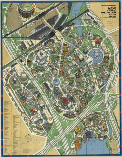
Map of New York’s 1964 World’s Fair. Click the link to see this map in our Digital Collections!
The United States withdrew membership from the BIE in 2002, but in 2017 rejoined. And maybe, in the near future, we can expect another Fair, as part of America’s long legacy of World’s Fairs, looking forward into a bright future.
Century of Progress Maps
by Judy Aulik
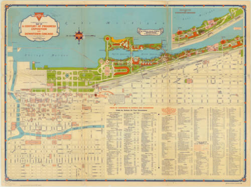
Chicago, celebrating an ill-defined centennial, hit the 40th anniversary of its 1892-1893 World’s Columbian Exposition with the Century of Progress fair of 1933-1934. Map publishers went into overdrive to commemorate the first large World’s Fair of the auto tourism era. Oil companies which commissioned these road maps for their gasoline brands include Barnsdall, Conoco, Deep-Rock, Diamond, Gulf, Lubrite, Pennzoil, Pure, Shell, Standard (Indiana), and Vacuum Oil. Both H.H. Gousha and Rand McNally produced many road maps for the occasion: some were essentially Chicago vicinity maps with an inset of the lakefront fair grounds. Some bore specially designed covers, such as those from Barnsdall and Pure. Others showed routes with a symbol celebrating each exhibit hall. Even post card manufacturer Curt Teich published a commemorative road map for its hometown!
But not every attendee drove. Many used the railroads instead. The Chicago & Northwestern Railroad was an obvious choice for those west of the city. However, five electric line stations plus the Illinois Central’s Central Station served the Century of Progress and the museums.

Although Chicago is a well-planned city, a city map and exhibit map would be welcomed by the tourist. In 1934, Illinois Central Railroad issued a Rand McNally map for this purpose.
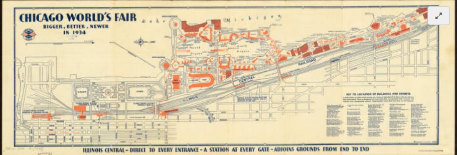
Oddly, this is oriented east-west as opposed to a road map. By this time, the convention of using the top edge of the sheet being north was nearly universal. Lake Michigan comprises its top edge.
The Century of Progress Deco exhibit buildings do not survive, with the exception of a House of Tomorrow, on Beverly Shores, Indiana. Since 1997, the IC rail yards are greatly reduced, and Millennium Park occupies some of the area shown on this map. IC’s Central Station is demolished, but Chicago’s lakefront was returned to the people.
Click here to view the AGS Library copy in the Digital Map Collection
