Africa
Ocean liner routes between Germany and Africa, 1914
by Angie Cope
Afrika / Geograph. Anstalt von Wagner & Debes, ; L. Friederichsen & Co. ; Woermann-Linie A.G.
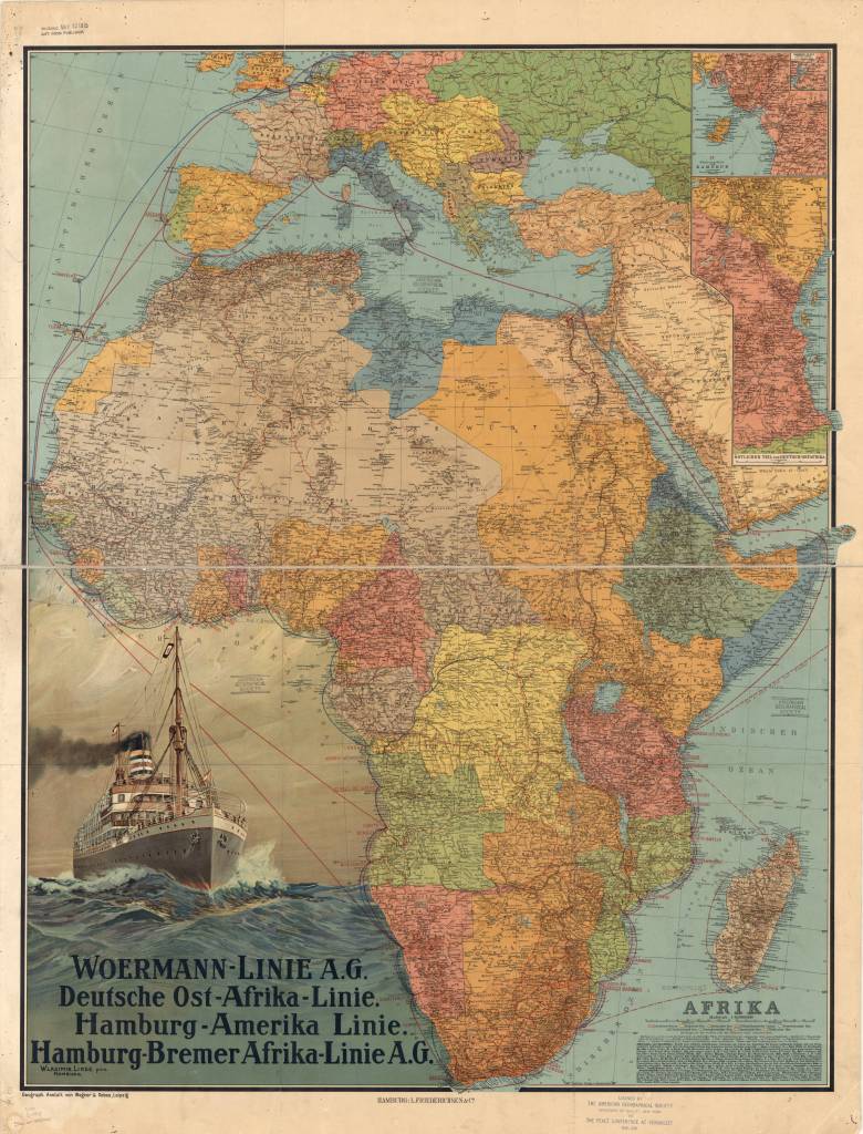
This map of Africa was published in Germany in 1914, shortly before the outbreak of World War I. It shows the ocean liner routes between Germany and Africa, as well as coastal and inland routes.
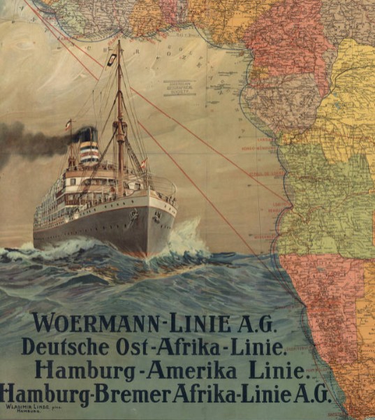
Relief is shown by hachures and spot elevations. In the lower left are an illustration of a steamship on the high seas and a listing of the major German steamship lines providing service to Africa, Woermann-Linie A.G., Deutsche Ost-Afrika Linie, Hamburg-Amerika Linie, and Hamburg-Bremer Afrika-Linie A.G.
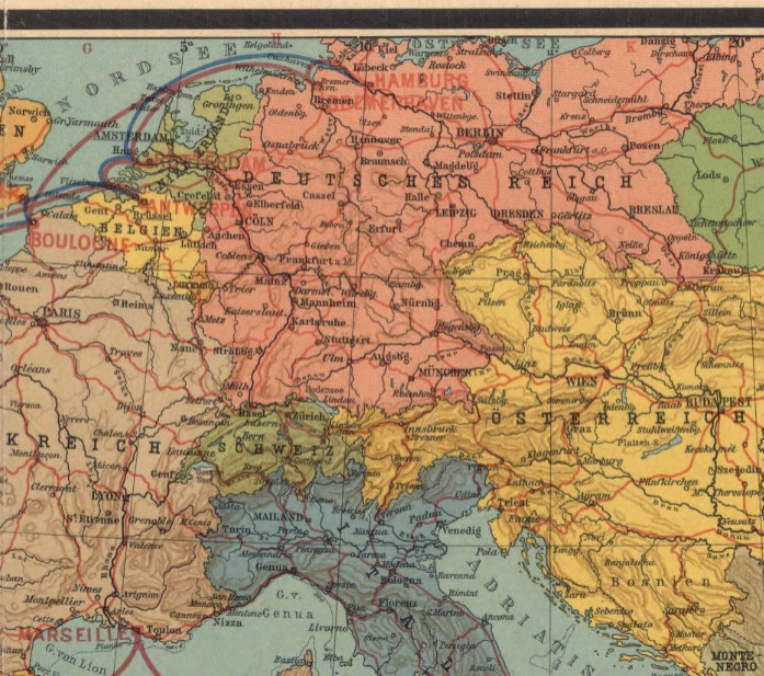
In the upper right is an inset map of the coastal region of the German colony of Cameroon and an inset to the inset showing the inland course of the Cameroon River. Below these maps is another inset showing the eastern part of German East Africa. The key at the lower right indicates the wealth of information contained in the map.
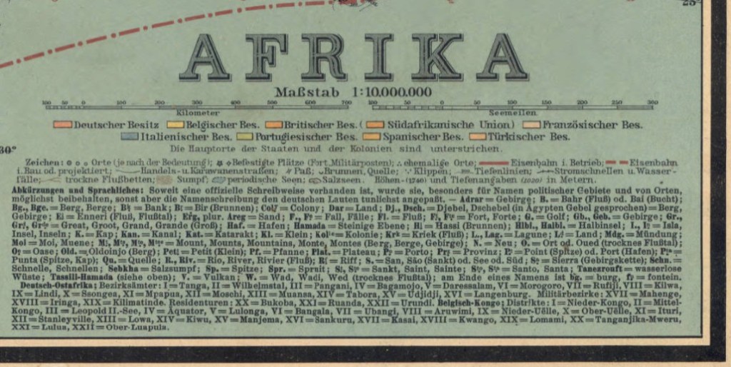
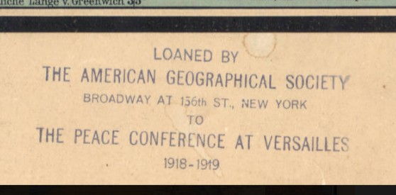
Two distance scales are provided, kilometers and nautical miles. Different colors are used to mark the colonial possessions of Germany, Great Britain, Belgium, France, Italy, Portugal, Spain, and Turkey. Symbols indicate cities and towns by population size, forts and military posts, ruins, railroads (operational and planned), caravan routes, mountain passes, wells and springs, and swamps and other geographic features. There is an alphabetical list of abbreviations for geographic terms in local languages and their German equivalents. Roman numerals are used to identify the districts and other administrative divisions in the Belgian Congo and German East Africa. The map was prepared by Wagner & Debes, a German firm that specialized in providing maps for inclusion in the famous guidebooks for travelers published by Karl Baedeker in the 19th and early 20th centuries. A stamp at the bottom indicates that the map was loaned by the American Geographical Society of New York to the Peace Conference at Versailles, 1919.
View map in the American Geographical Society Library Digital Map Collection
https://collections.lib.uwm.edu/digital/collection/agdm/id/364/rec/1
Manuscript maps by Adolph N. Krug, an American missionary in Cameroon in the early 20th Century
by Angie Cope
The AGS Library has 3 manuscript maps drawn by Adolph N. Krug, an American missionary in Cameroon in the early 20th Century.
Krug was born in 1873 in Germany and immigrated to the United States at the age of 15. He studied at Amherst College, graduating in 1903. That same year, he married Miss Evelyn E. Saul and they both left for Cameroon under the appointment of the Board of Foreign Missions of the Presbyterian Church of the USA.
Krug traveled the country, opening schools and churches and mapping the trails. It was his mapping efforts that led to his membership as a fellow in both the the Royal Geographical Society and the American Geographical Society.
Toward the end of his career, Krug was in charge of the village school in Foulassi. In 1941 he and his wife returned to the states to address Krug’s health condition. Krug died of heart failure in 1942. Mrs. Krug returned to Cameroon where she lived until her death in 1951. Their four children became missionaries in Asia and Africa.
Two of the manuscript maps held at the AGSL depict the trails, missionary sites, rivers and locations where Krug set up schools and churches. One of these is a “photostat” made by the American Geographical Society of Krug’s manuscript map. It is unknown where the original is located – perhaps at the Royal Geographical Society.
The third manuscript map is Krug’s manuscript reproduction of Dr. Marcel Chambon’s map showing the French medical survey of Cameroon. Chambon was a colleague of Dr. Eugene Jamot and the two of them working together were instrumental in trying to combat the African sleeping sickness
In addition to his mission work, Krug was interested in the life of the indigenous peoples, especially their folklore. The Journal of American Folklore published a number of “Bulu Tales” collected by Krug over his 39 years in Africa.


Click on any image above to open a larger view.
Map 1
Part of district of Ebolowa with outposts of Sangemalima and Ako’o Afem / drawn by A.N. Krug, M.A., cyclometer measures and compass direction. [Photostat/photocopy]
Adolph N Krug ; American Geographical Society of New York.
Foulassi, Cameroun : Adolph N. Krug New York, New York : American Geographical Society of New York ; 1911
Map 2
District subdivision, Sangmelima, Cameroun.
Adolph N Krug
1927?
Map 3
French medical survey of sleeping sickness in Sangmelima / Dr. Chambon (copied with his permission by A.N. Krug).
Marcel Chambon ; Adolph N Krug
192-?
