Imperial Russian Black Sea Atlas at the AGSL Part II
By Josephine Miller
Black Sea Atlas
The atlas became a significant work. It would be used by the Russian military for the next 30 years.[1] Manganari’s nautical charts were used as a base for the later editions published by the Imperial Navy. Even the Soviets used Manganari’s charts as a base in the 1920s, about eighty years after the original atlas was published. These later editions are held by the AGS Library. In the AGS Library’s possession are Black Sea and Azov nautical charts that date from the 1880s to the 1920s. Illustrations and corrections were added to later editions. These illustrations include lighthouses, large buildings, sea marks, and day marks to facilitate navigation. Newer measurements of compass declination were also added. However, much of the original Manganari charts remained in the later editions. His drawing of the coastlines, topography, and bathymetry remained as a base for future editions into the early Soviet era. The soil reports given from his nautical charts remained as well. Additionally, the map scales were kept in later editions.
As for the coastlines of the nautical charts, they were drawn according to astronomical and trigonometric calculations. This can be seen virtually all of the nautical charts of the Black Sea Atlas:

“Shore is determined by trigonometric means and many astronomical observations.” From Карта Части Сѣвернаго Берега Черного Моря отъ Одессы до Мыса Херсонеса (A Map of Northern Black Sea Coast, Odessa to Cape Chersonesos). Click the link to see the entire map!
Navigational routes, drawn as sea lanes, are essential to nautical charts. To aide navigation, landmarks and seamarks are given. Manganari plotted different kinds of lines to indicate valuable information for navigation. Each chart in the atlas has almost identical legends in regards to navigation. However, there is slight variations between charts due to mountains or cultural landmarks. These cultural landmarks are usually religious, such as churches and mosques. Here is the legend from the 1891 edition of the Northern Black Sea Coast.
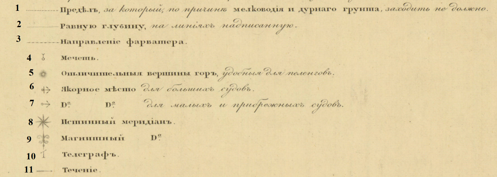
1. The limit for which, due to shallow water and bad soil, should not enter. 2. Equal depths on the plotted line. 3. Direction of fairway. 4. Mosque. 5. Distinctive mountain peaks, convenient for bearing. 6. Anchor place for large ships. 7. Anchor place for small and coastal ships. 8. True Meridian. 9. Magnetic Meridian. 10. Telegraph 11. Tide or Current.
One area of British influence in Russian cartography is measurement. A larger than life ruler, the impact of Peter the Great carried long after his death. His reign is reflected in the field of Russian cartography. Inspired by his tour of the West, he established in the Imperial Navy in 1696. Peter’s command to westernize Russian government brought Western cartography to Russia, military largely in mind. One major reform was to implement British measurements for military use. Consequently, almost two centuries later, the Russian Navy used the British Imperial measurements in its nautical charts. This can be seen on the AGSL’s charts. The Imperial measurements were used for distance and depth.
On this 1891 edition nautical chart of the northern Black Sea coast, the map scale uses British measurements:
On this 1891 edition nautical chart of the northern Black Sea coast, the map scale uses British measurements:
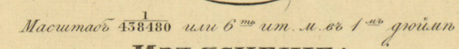
Map Scale of Карта Части Сѣвернаго Берега Черного Моря отъ Одессы до Мыса Херсонеса [Northern Black Sea Coast, Odessa to Cape Chersonesos].

Another example of British measurments is found on the same chart, depth.
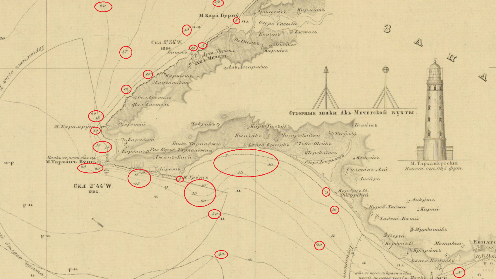
“Depth of sea height measured in six-foot English fathoms – rivers and estuaries in feet.”
Circled below are the depth marks.
From Карта Части Сѣвернаго Берега Черного Моря отъ Одессы до Мыса Херсонеса (Northern Black Sea Coast, Odessa to Cape Chersonesos). Click the link to see this map in our Digital Collections!
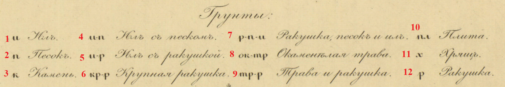
In addition to depth, Managanari recorded the soils of the sea floor.
Карта Части Сѣвернаго Берега Черного Моря отъ Одессы до Мыса Херсонеса (Northern Black Sea Coast, Odessa to Cape Chersonesos). Click the link to see the whole map in our Digital Collections!
- Silt
- Sand
- Rock
- Silt with sand
- Silt with shells
- Large Shell
- Shell, sand in silt
- Petrified weeds
- Weeds and shells
- Plate
- Cartilage or Gristle
- Shells
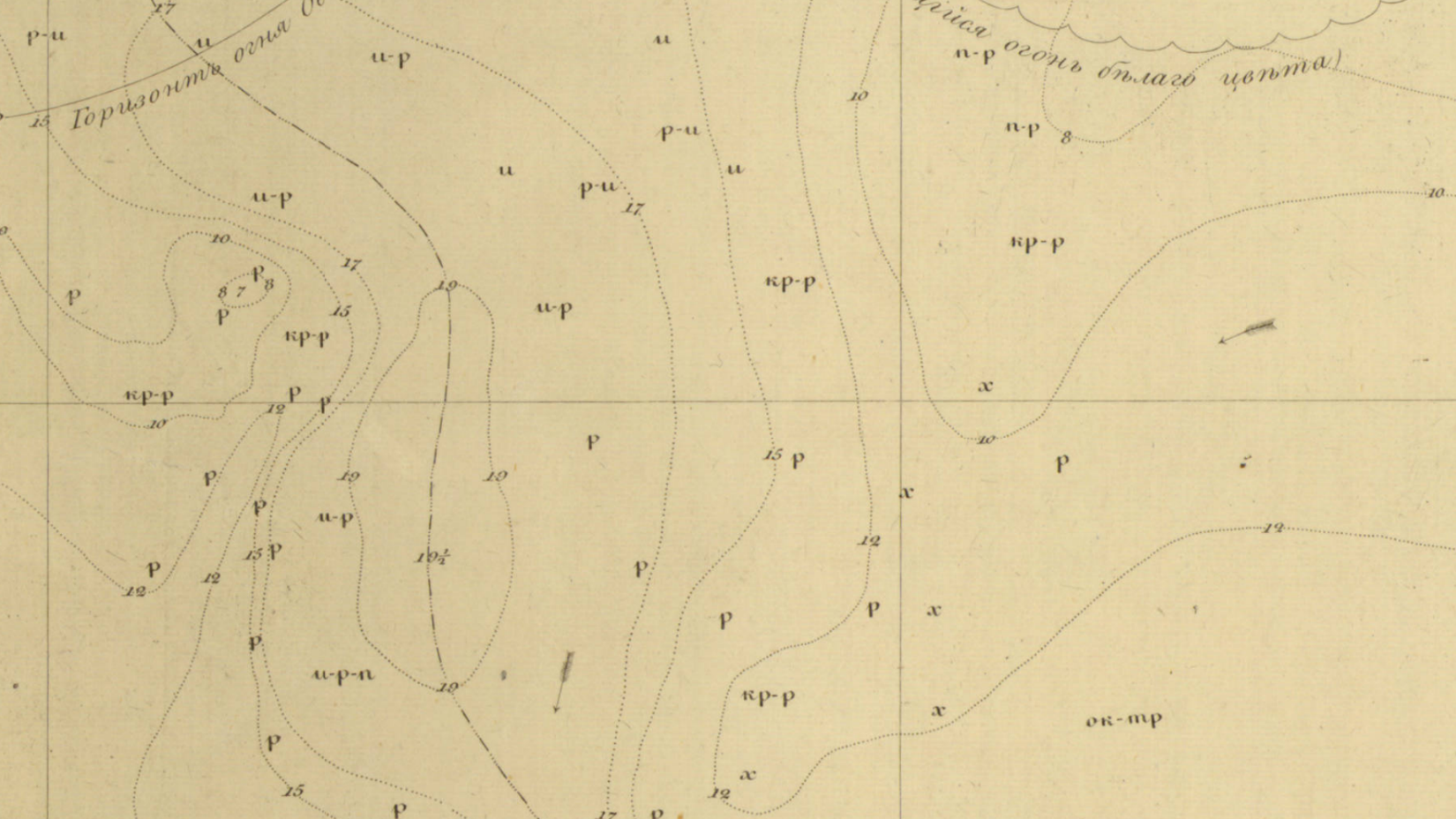
Sea floor on the chart. The letters represent soils as indicated by the legend.
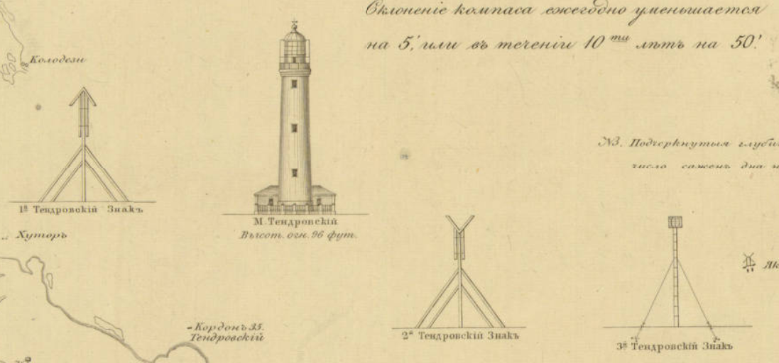
Later editions published after the Treaty of London (1870) include lighthouses and seamarks. Here is the Lighthouse of Tendra Bay on the Southwestern coast of Ukraine. It is noted as 96 feet. Beside it are seamarks. These landmarks aide navigation.
A significant factor to navigation is the prime meridian. In the early 19th century, the Russian militray did not use Greenwich as the prime meridian for its cartography. Instead, Manganari used the Pulkovo Meridian as the prime meridian, which was the practice in Russia at the time. The Pulkovo meridian is located at the Pulkovo Observatory in Saint Petersburg. In the spirit of the reforms in Alexander’s II reign, the later editions adopted Greenwich.

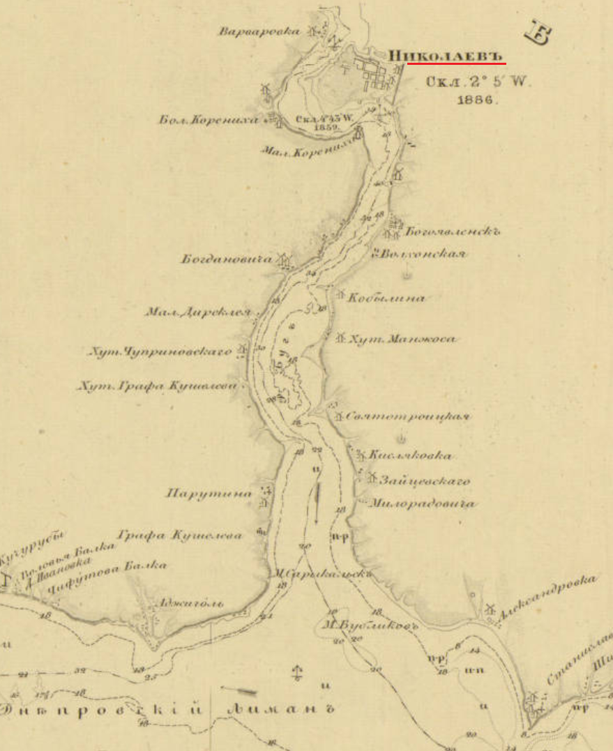
Nikolayev was a base of the Black Sea Fleet. It was also the location of the Depot of the Hydrographic Department of the Black Sea Fleet for the Imperial Navy. In1803, the depot was founded at the request of the Marquis de Traverse, Commander-in-Chief of the Black Sea Fleet at the time. It was established for the engineering needs of the fleet. There, the nautical charts of the Black Sea Atlas were drawn and compiled before engraving. Later editions of the charts were published in Nikolayev. [2]
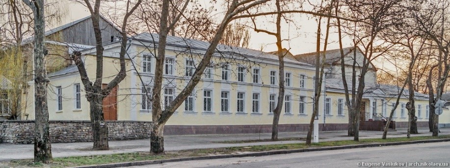
Map Depot of the Hydrographic Department, Black Sea Fleet, Imperial Russian Navy, Nikolyaev. Click the link to learn more!
Later editions borrow from Vice-Admiral Thomas Abel Brimage Spratt (1811-1888). Spratt had an extensive career in the British Navy as an officer, hydrographer, and geologist. He produced a repertoire of nautical charts for the British Admiralty. He was a fellow of the Royal Geographical Society of London, the Zoological Society of London, the Society of Antiquaries of London, the Royal Society of London. The Crimean War provided Britain with the opportunity to survey the Black Sea. The then Captain Spratt completed nautical surveys of the Black Sea during the war. In May of 1851, Captain Spratt was given command of the paddle steamer HMS Spitfire to survey the island of Crete. This was the ship he used in the 1850s for his surveying of the Black Sea as it is noted on the nautical charts of the later editions.
The conditions of the Treaty of Paris (1856) is a primary reason why the Russian Navy would use Spratt’s maps in their own nautical charts of the Black Sea. Given that the Russian Navy could not have fleet in the Black Sea after the Crimean War, the navy could not perform its own surveying in the Black Sea. This situation lasted until the abrogation of the Black Sea clause by the Treaty of London in 1870. For the latter half of the 1850s and through the 1860s, Russia was without a fleet in the Black Sea to do the surveying required for nautical charts. Thus, the Russian navy had to find other sources for the information that they could not gather themselves in the time period. One source would be the Spratt’s surveys. By 1870, when Russia could rebuild the Black Sea Fleet, the most recent Russian survey of the Black Sea was Manganari’s atlas. However, the atlas had been published in 1841-1842 with surveys from the 1820s and 1830s. Spratt’s work was more recent dating to the 1850s. For that reason, Spratt’s work was included in the later editions of the 1880s and 1890s.
The legacy of Captain Manganari carried through one century into the next. His charts for the Black Sea Atlas that he surveyed in the 1880s would be used as a basemap for later editions. Even the Soviets used Managanari’s charts in the 1920s, almost century after Manganari published the Black Sea Atlas. The Black Sea has historically been signifcant for trade and militrary power. It has always has been a politcally contentious region, and remains so to this day. For this reason, the nautical charts of the Black Sea Atlas reflect the political situtiation and its military conflicts in the 19th century.
[1] Ibid.
[2] Васюков, Евгений ; Архитектура Николаева. Депо карт. [Vasi͡ukov, Evgeniĭ ; Nikolayev Architecture. Map Depot.] http://archmykolaiv.com/depo-kart/.
