Native American Mapping of the Belcher Islands
by Angie Cope
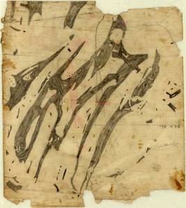
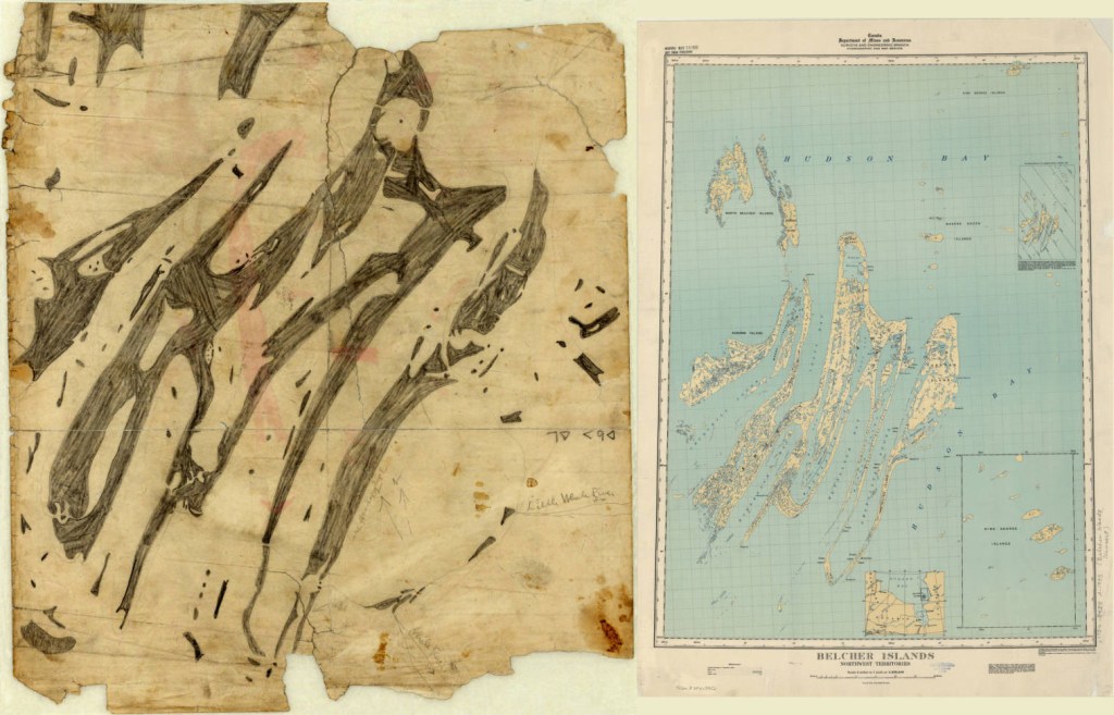
This map is the central object in the story of how geographical knowledge was passed from an Inuk man named Wetalltok to a non-native explorer. In an article in the Geographical Review in 1918, Robert J. Flaherty (1884–1951) recounted the story of how, while he was searching for iron ore deposits on the east coast of Hudson Bay, Canada, Wetallok explained the intricacies of the bay’s island system and shared with him this remarkably accurate Eskimo map, which Flaherty reproduced in the article.
Flaherty later became a director and producer whose first film, Nanook of the North (1922), was one of the best known documentaries of the silent-era. Flaherty also told the story of his encounter with Wetallok in his 1924 book, My Eskimo Friends: “Nanook of the North.” Recent historians of cartography, notably G. Malcolm Lewis in Cartographic Encounters: Perspectives on Native American Mapmaking and Map Use, and Lewis and David Woodward in History of Cartography, also have used the map as an example of indigenous cartography.
The map is drawn with pencil on the back of a missionary lithograph. Notations are in English and Inuktitut syllabics. Flaherty’s annotations include “Little Whale River” [with arrow], “Whale River” [with arrow], and “3 days = dogs = app. 70 miles.”
Click here to view the map in the AGS Library Digital Map Collection
Creating a school wall map in 1913
This print shows three building views of Justus Perthes’ Geographische Anstalt in Gotha, Germany. The illustrations show the process used in the creation and printing of Justus Perthes school wall maps in 1913.
View this item in the AGS Library Digital Map Collection
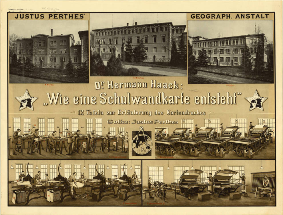
Points identified in red are indexed in: Wie eine Schulwandkarte entsteht : eine Führung durch die lithographischen Werkstätten von Justus Perthes’ Geographischer Anstalt / von Hermann Haack, 1913 (viewable here: http://uwm.edu/libraries/agsl/schulwandkarte/ )
WWII Road Map Censorship in the United States
by Angie Cope
 I enjoyed reading David Smollar’s article on road map censorship during World War II in the latest issue of “The Legend,” the newsletter of the Road Map Collectors Association. Map makers H.M. Gousha, General Drafting Company and Rand McNally worked with the U.S. Government to eliminate features of strategic importance from their maps.
Called “wartime masking,” the removal of features such as airports, military and war-related industrial targets occurred on maps from 1942 and 1943.
Whenever I read articles that point out interesting features of maps, I’m always curious to see them for myself. It seems the American Geographical Society Library doesn’t have many road maps by these three publishers for the years 1942 or 1943. I did find a Los Angeles map by Gousha and was able to compare the 1940 with the 1942.
Airports were shown in purple on the 1940 map and masked on the 1942 map. Long Beach Municipal Airport (Daugherty Field) is shown in the top pink circles and Ardis Airport is shown in the pink circles at the bottom on the 1940 map (at the left). Even the map key is edited or masked, removing the purple symbol for the airport on the 1942 map.
Soller’s article is a very interesting read citing extensive research at the Newberry Library, the National Archives and the Library of Congress. I highly recommend reading the Summer 2015 issue of “The Legend.” Information about the Road Map Collectors Association can be found here: http://roadmaps.org/
Chinese Propaganda Posters
by Sean Yan
Chinese propaganda posters were a product of the Chinese Communist Party in the twentieth-century, created to glorify the efforts of the party. The posters were also intended to reinforce harmony between citizens and the government. They can usually be found in newspapers, calendars and textbooks. Artists today are inspired by these posters to capture this period in history and at the same time, to show criticism. There is a growing popularity of the propaganda poster style among designers of home decor and apparel, and this style is especially popular with the younger generations in China.
It has been more than a year since I first came to the U.S. from China. Although I was born and raised much later than when the propaganda posters were most popular, there were still many propaganda poster elements in Chinese society in the 1990s. One of the first projects I worked on after being hired at the AGS Library was the scanning of about 21 of these propaganda posters. I was surprised to see these posters, which haven’t been seen for years in China, here in Milwaukee. It feels different to see this collection in the U.S because most of what I had seen was in elementary school textbooks.
The AGS Library has 21 posters in total and here are a few examples:
*Note: “Ten thousand years” is a phrase which expresses people’s worship of an emperor in ancient China, but it also can be used as a feeling of triumph. (There is a little bit of both in my personal view, the same for the other posters shown)

The poster above shows a character in contemporary ballet called “Red Detachment of Women (红色娘子军)” which is regarded as a masterpiece in modern China.

People in the poster above are standing in front of Tian’an Men, which is a national symbol of China. The poster stands for the unity of the 56 ethnicities of the entire nation. This is a very common image that you find in offices, homes and even some local government buildings.

This poster reminds people of the “Military doctrine for the Chinese Red Army.”
The three rules are: 1. prompt obedience to orders; 2. no confiscation of people’s property; 3. turn in everything captured.
The eight points for attention are: 1. be polite when speaking; 2. be honest when buying and selling; 3. return all borrowed articles; 4. pay compensation for everything damaged; 5. do not hit or swear at others; 6. do not damage crops; 7. do not harass females; 8. do not mistreat prisoners.
This poster is very representative of the great Cultural Revolution, started in 1966 and ended by 1976, which meant to reinforce Mao’s Communism by purging remnants of capitalist and traditional elements from Chinese society. “Lin” refers to Lin Biao who was the vice president of People’s Republic of China and “Kong (孔)” refers to Confucius. Due to Mao’s political theory, he encouraged the public to criticize Confucius, Confucianism and Lin who was officially condemned as a traitor by the Communist Party after a failed coup attempt against Mao.
As a surgeon, Bethune greatly helped Eighth Route Army soldiers who had been wounded on the front line during the Second Sino-Japanese War that would earn him enduring acclaim. Dr. Bethune was greatly praised by Mao and has been included in school textbooks ever since.
You are more than welcome to leave any comments below in regards to Chinese propaganda posters or anything about China. Feel free to stop in and check out the rest of the posters and our collections at AGS Library 3rd floor, east wing of UWM Libraries.
Documents from Formosa
by Bob Jaeger
Taiwan, formerly known as Formosa, was under Dutch colonial rule from 1624-1662, primarily to trade with China and Japan. The Dutch missionaries also had other motives, such as attempting to convert the aborigines to Christianity. But at the same time, they also taught them reading and writing, using romanization schemes for the different Formosan languages.
After the Dutch were expelled by China, some of the aborigines retained this system of writing, which they continued to use for roughly the next hundred years.
The American Geographical Society of New York Archives contains three documents by the aborigines written during this period of post-colonization. They are all land contracts with China.
The AGS acquired these documents from Joseph B. Steere in 1874. A professor of zoology at the University of Michigan, Steere visited Formosa for six months from 1873-1874. He collected various types of biological and anthropological data from the island and its people. The documents date from 1723-1776 and vary in size and handwriting.
These particular documents are written in the Pepowhan (Siraya) language, which was spoken in the southwestern plain of Taiwan. The language became extinct in the first half of the 19th century, but can still be translated by scholars who specialize in the aboriginal people of Formosa. This artifact is held at the AGS Library, UW Milwaukee as part of the American Geographical Society of New York Archives.
Open Milwaukee County Topographic and Planimetric Data
By Stephen Appel
Open data in Milwaukee has made a huge leap forward this year with the new download capabilities from the Milwaukee County Automated Mapping and Land Information Service (MCAMLIS) out of the Milwaukee County Land Information Office (MCLIO). The MCAMLIS viewer is a feature-full web mapping application that can be found at http://lio.milwaukeecounty.org/mcamlis/. The current web viewer is in its second generation and we expect a third generation web map soon!
In the past, the American Geographical Society Library has entered into a license agreement with the MCLIO which allowed us to distribute the raw data from the MCAMLIS system to UWM users for classroom use only. The data has been available in geodatabase, AutoCAD, and Microstation formats and has been most popular with Urban Planning, Geography, and Architecture students and researchers. Library patrons requesting the data had been required to sign a special MCAMLIS request form and agree to the conditions of the license. The library was also restricted from providing the full county dataset and instead distributed tiles to cover a patron’s area of interest.
As of this year, the MCLIO has made MCAMLIS base map data available for download from their website: http://county.milwaukee.gov/mclio/geodata/imagery/Data-Download-Form.htm. They have also implemented a data download application which is especially helpful if you are only interested in a limited area of the county. The application allows for download of Geodatabase and AutoCAD Drawing formats. The data download application can be found in the online application gallery: http://county.milwaukee.gov/mclio/applications/appgallery.html.
The MCAMLIS topo/planimetric dataset is one of the best collections of high resolution planning data available for Milwaukee County. The features include environmental, hydrologic, park, planimetric, survey control, topographic, transportation, and utility objects. Within each of these categories, there are three feature classes representing 1) text annotations, 2) point features, and 3) line features. In the new File Geodatabase, some of the line features are also available as polygons.
Some of the more useful features that can be extracted from the geodatabase include utility poles, elevation bench marks, topographic contours, tree points, paved roads, driveways, trails, sidewalks, railroads, airport runways, water bodies, structures (buildings), dams, bridges, walls, and text annotation features.
If you think that the MCAMLIS topographic and planimetric features would be useful for your project, but you’re unsure about the data, the AGS library GIS services staff can help. We have been users and distributers of this dataset for almost two decades and have extensive metadata and feature description information that are not included with the download from the MCLIO website. We also have a guide available for extracting individual features from the larger dataset. Contact gisdata@uwm.edu or visit our GIS staff at the AGS library if you would like more information about the MCAMLIS datasets.
A Fan with a View
by Bob Jaeger
Arctic Fan. Kinda sounds like an industrial strength air-conditioner, one that would keep your house extra cool in the summer. But these words describe a nineteenth-century hand-held fan with an Arctic view painted on it. This fan is held at the AGS Library, UW Milwaukee as part of the American Geographical Society of New York Archives.
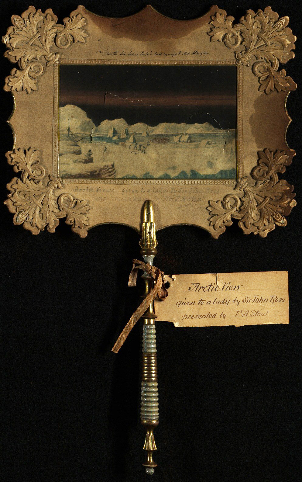
While it is unclear who painted the image, the fan was given to a Miss Allington by the Arctic explorer John Ross (1777-1856), who made three voyages to the Arctic. It was later presented to the AGS by one of its vice presidents, Francis A. Stout in 1871.
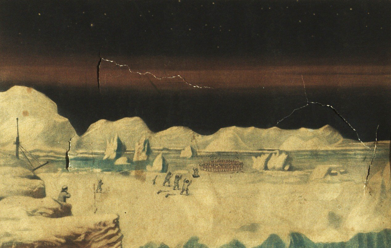
The fan is ornately designed, with a watercolor painting of an Arctic scene, an elaborate wooden handle, and a decorative trim and border. In an era without air conditioning, a snowy landscape like this might have helped keep the user a little bit cooler when looking upon this wintery scene.
We’d love to learn more about this fan and invite comments below.
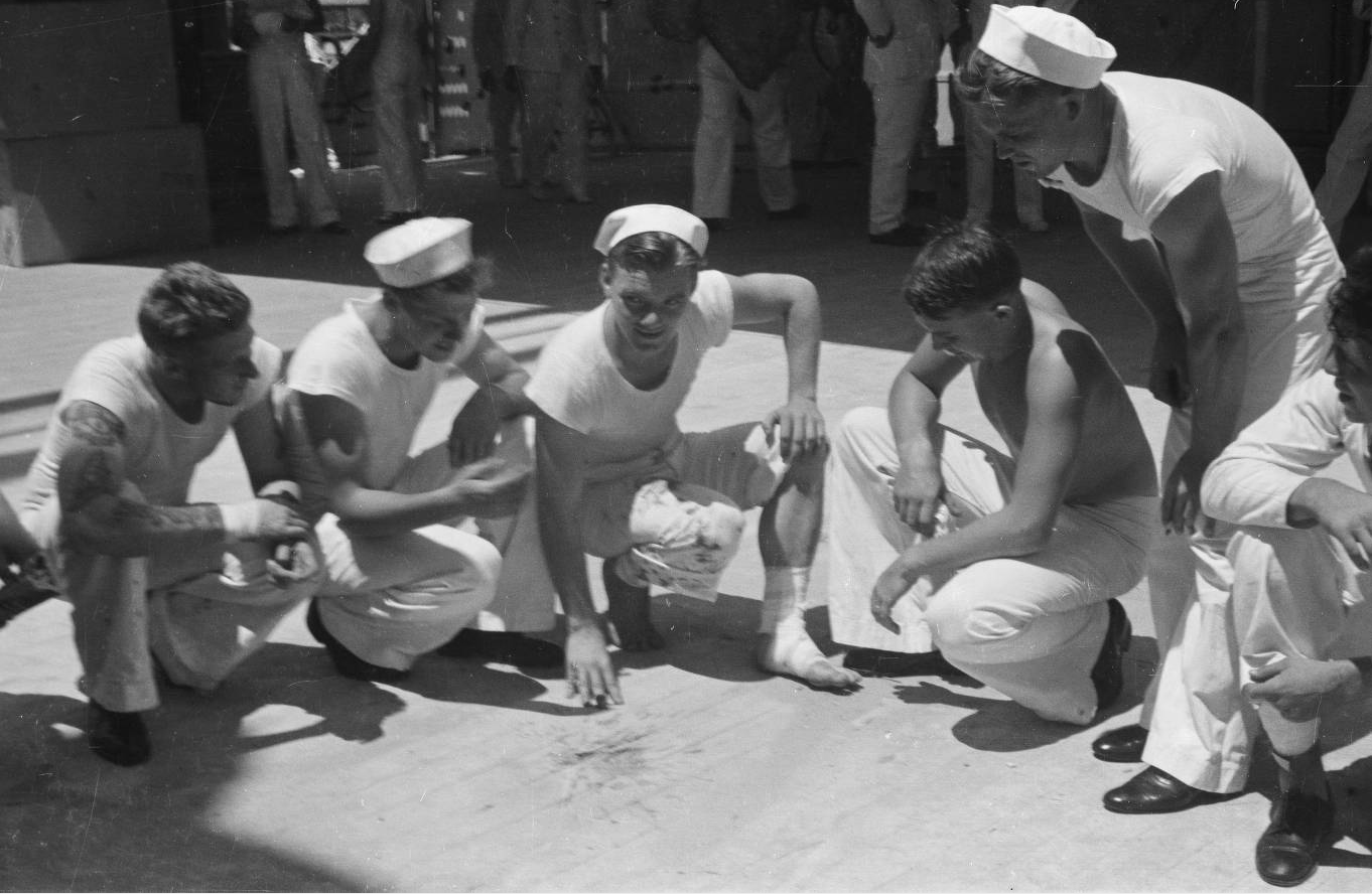
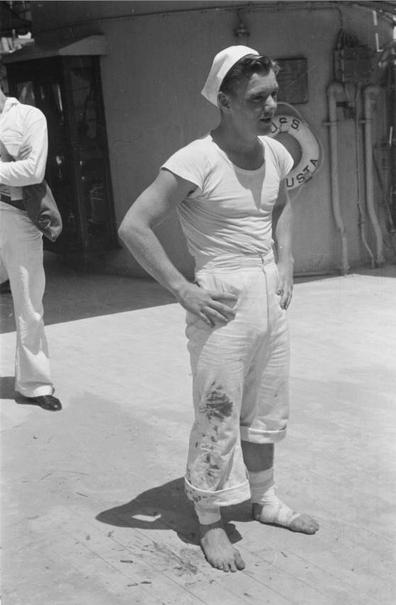
Tragedy On Deck of the USS Augusta: First American Military Casualty of World War II
By Susan Dykes
On August 20, 1937, the crew of the USS Augusta which was docked in Shanghai, China were gathering for a morale-boosting movie on deck. Their night of entertainment, however, turned into a devastating incident which would become a significant moment in World War II history.
In the midst of one of the fiercest battles between Japanese and Chinese forces, the USS Augusta reached Shanghai just days before the incident on ‘Bloody Saturday,’ August 14, 1937. Though the United States had not officially entered the war at the time, the ship and crew were tasked to protect and help evacuate American and European citizens from the escalating danger in the international settlements of the Bund – the central business district of Shanghai. Marines from the USS Augusta were joined by those from the USS Sacramento to also protect Shanghai’s power plant, an operation that put the sailors directly in the line of fire.
The USS Augusta was thought to be secure on the night of the on-deck movie, despite the ship being surrounded by fighting and the presence of Japanese ships anchored in the nearby Huangpu River.
As the sailors were preparing to watch the movie with screen and benches brought from below, an anti-aircraft shell landed on deck sending shrapnel into the crowd taking the life of 1st Class Seaman Freddie John Falgout and injuring eighteen other sailors. Falgout, a native of Raceland, Louisiana, was about to celebrate his 21st birthday the next day. News of the incident quickly reached the United States, appearing in major newspapers and on the cover of the New York Times.
American Geographical Society Library staff discovered rare images of the aftermath of the incident in the AGSL Photographic Collections. The images, showing injured sailors and the deck where the shell hit, were taken by Harrison Forman and are available online in the UWM Digital Collections.
Link: http://collections.lib.uwm.edu/cdm/ref/collection/agsphoto/id/12595
Link: http://collections.lib.uwm.edu/cdm/ref/collection/agsphoto/id/12599
The Battle of Shanghai lasted months, eventually resulting in the Japanese occupation of Shanghai. It was considered one of many military battles that led to World War II, thereby making Falgout the first American military casualty of the war. In 1987, Senator J. Bennett Johnston, Jr (D) from Louisiana, honored Falgout as such, submitting an article about the incident from the Sacramento Union, which was printed in the Congressional Record.
View all images of the USS Augusta http://collections.lib.uwm.edu/cdm/search/searchterm/forman%20augusta/field/all/mode/all/conn/and/order/title/ad/asc/cosuppress/0
Fordlandia, Brazil
by Angie Cope
I’ve worked at the AGS Library for over a decade and I am still amazed to find materials on nearly every topic. A couple years ago I caught the last 15 minutes of the PBS television special on Henry Ford (available online). Among Ford’s successes and failures was mention of his Utopian community built in the Amazon rainforest. Returning to work, I checked the map drawers to see if I could find any maps of Fordlandia.
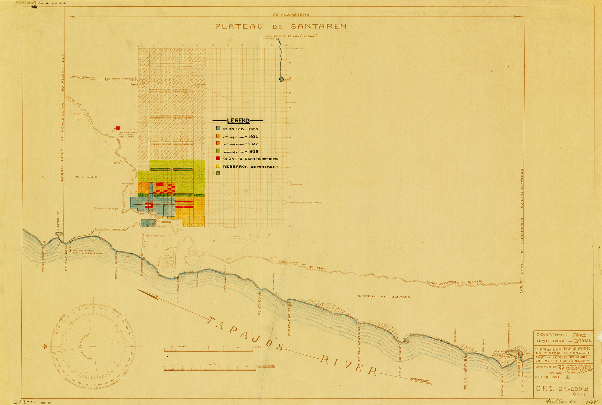
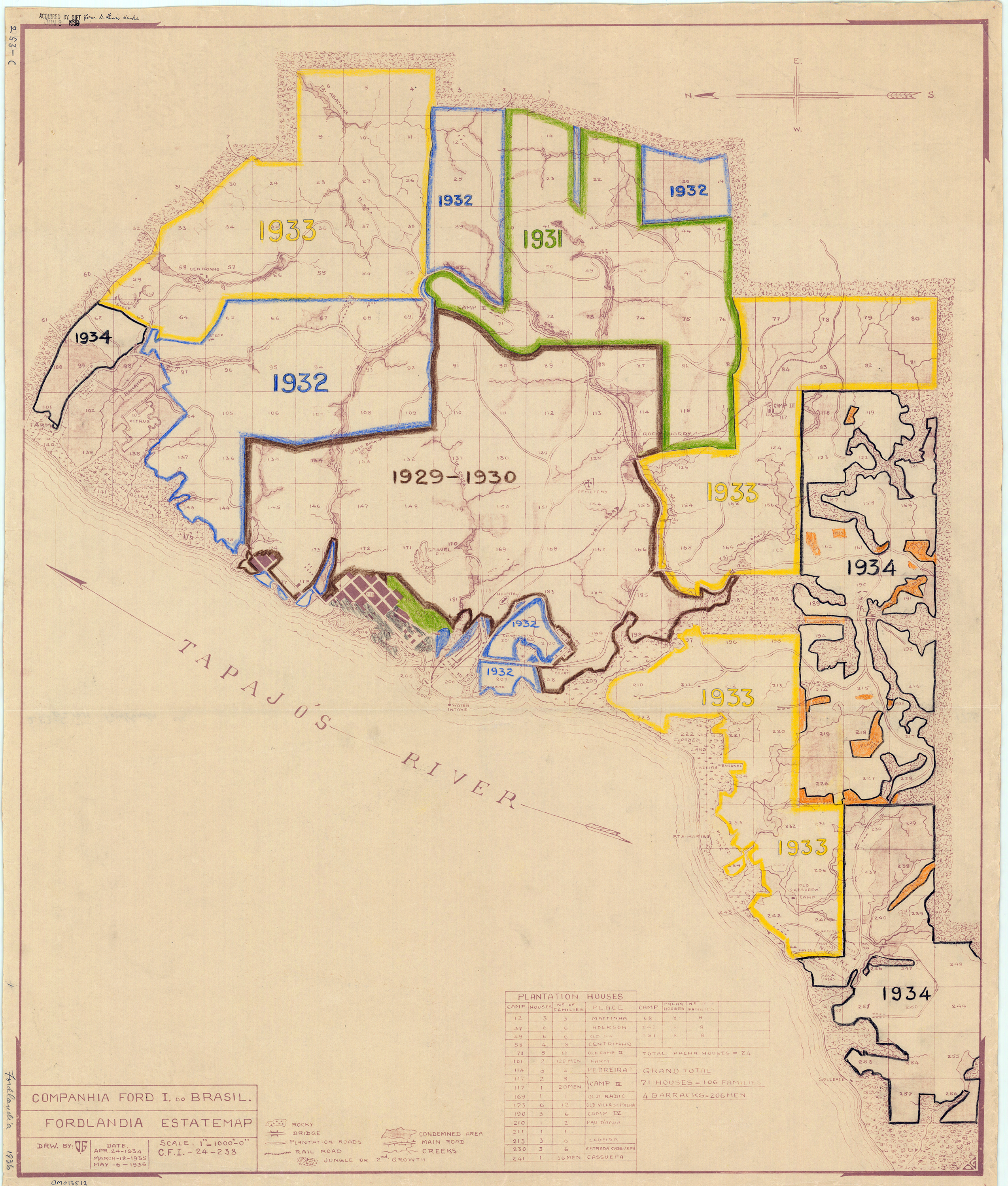
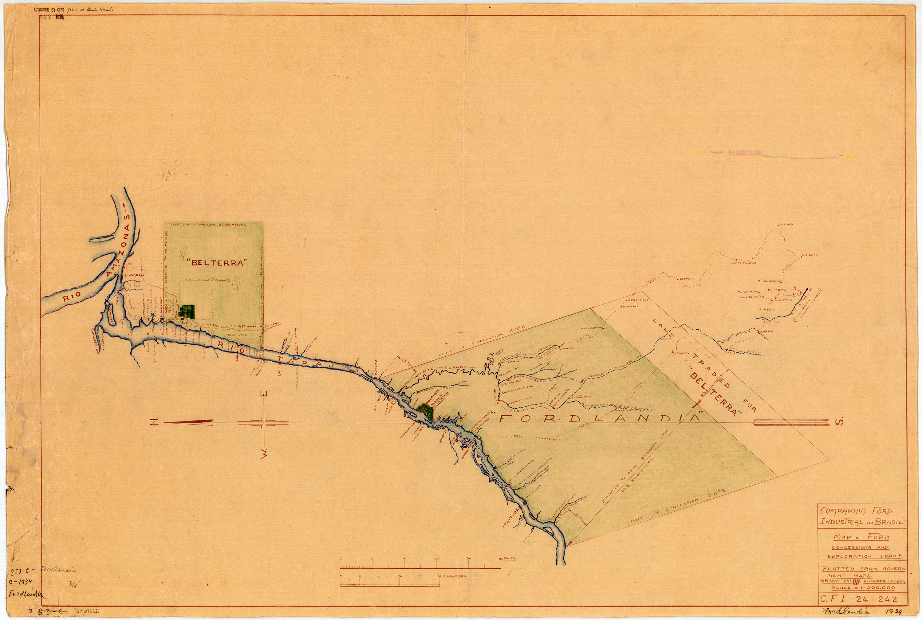
Sure enough, I discovered three annotated, blueline print maps dontated to the AGS in 1939 from Dr. Lewis Hanke. Hanke was a preeminent Latin American historian who corresponded with the AGS while researching his Handbook of Latin American studies.
The Fordlandia story generally goes like this …
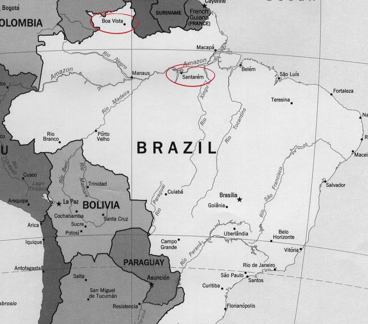
In 1927 Henry Ford purchased 2,471,000 acres of land in the Amazon rainforest from the State of Para, Brazil. Ford ambitiously hoped to free his company’s dependence on foreign rubber by starting a rubber plantation. This first concession of land was in the north of Brazil at Boa Vista.
Clearing of the land began in 1929 and production problems ensued almost immediately. Ford had relocated employees from the U.S. to run the plantation and hired local workers as labor. Personnel issues ranged from illness and homesickness to rebellion. The city was modeled after Dearborn, Michigan and had a power plant, library, golf course, barber, hospital, and housing for employees. Ford expected residents would enjoy leading a wholesome American lifestyle, eating hamburgers and living in homes similar to those in Dearborn. Quickly, local workers protested working conditions. Among their grievances was working 8 hours during the heat of the day when they were accustomed to working early-morning and late-evening shifts. Conditions became so bad that workers rioted.
________________________________________________
In addition to personnel issues, Ford’s engineers lacked knowledge of growing rubber trees. Seeds were planted too closely together making them easy prey for tree disease and pests. Before long, most of the trees died.
By 1934, the State of Para exchanged 695,586 of the original acres for an equal-sized waterfront area 30 miles south of Santarem. The original area, named Boa Vista, was never used as a plantation again but was used as a research station and laboratory for many years.
The new site of Belterra, with flatter topography, offered better conditions for producing rubber and allowed the use of machinery. However, a drop in demand for rubber and high costs of production made Belterra economically unfeasable for Ford. Eventually the plantation was sold to the Brazilian government.
Returning to my observation that the AGS Library has items on nearly every topic, I also enjoy how any map in the collection can distract the user in a dozen different directions. Whether writing about Lewis Hanke, the donor of the 3 Fordlandia maps, or simply researching the annotations – there is so much of interest to consider. Who annotated the maps? Who gave them to Hanke and why? What was Hanke’s relationship to the AGS of NY? Who is the O.G. cited as the draftsman of the maps?
There are many other great internet sites and books if you’d like to find out more about Fordlandia.
Historic images from the Benson Ford Research Center can be seen here.

The Ruins of Fordlandia (from “Damn Interesting” blog) by Alan Bellows is quite good
Fordlandia : the rise and fall of Henry Ford’s forgotten jungle city (2009) by Greg Grandin is a great read. (Description and review: http://www.popmatters.com/review/126045-fordlandia-by-greg-grandin/)
July 28, 2016 Update
Susan Dykes, the AGSL Metadata Specialist, recently discovered 43 photographs held at the AGS Library from Robert S. Platt in Fordlandia.
You may view them here:
http://collections.lib.uwm.edu/cdm/search/searchterm/fordlandia/field/all/mode/all/conn/and/order/title/page/1
Click here for information on the Robert S. Platt collection
Crocker Land: The Land of Mist
By Robert Jaeger
During Robert Peary’s attempt at reaching the North Pole in 1906, he claimed to have spotted a previously unidentified island off the northwest coast of Greenland. He named it Crocker Land, after one of his primary financial supporters, George Crocker.
While Peary may have fabricated the island’s existence in order to obtain further funding from Crocker for his next attempt at the Pole in 1909, Crocker Land nevertheless became a hot topic in 1909 after Frederick Cook and Peary both claimed to have reached the Pole.
During his expedition to the Pole, Cook stated that he traveled across the area Peary called Crocker Land and there was no land present. In an effort to prove the existence of Crocker Land and discredit Cook, George Borup and Donald MacMillan, both assistants of Peary on his trip to the Pole in 1909, were chosen to lead an expedition to Crocker land. However, Borup died unexpectedly, delaying the start of the expedition and leaving MacMillan to lead the expedition by himself.
MacMillan set out 1913, and the expedition was immediately beset with a series of misfortunes. Among them, a shipwreck on the way to Greenland, two failed rescue missions, the alleged murder of an Inuit guide, and the biggest of all: that Crocker Land turned out to be an illusion. At first MacMillan refused to believe it was a mirage caused by mist, but after several days of attempting to reach it, he was forced to accept the truth and turn back.
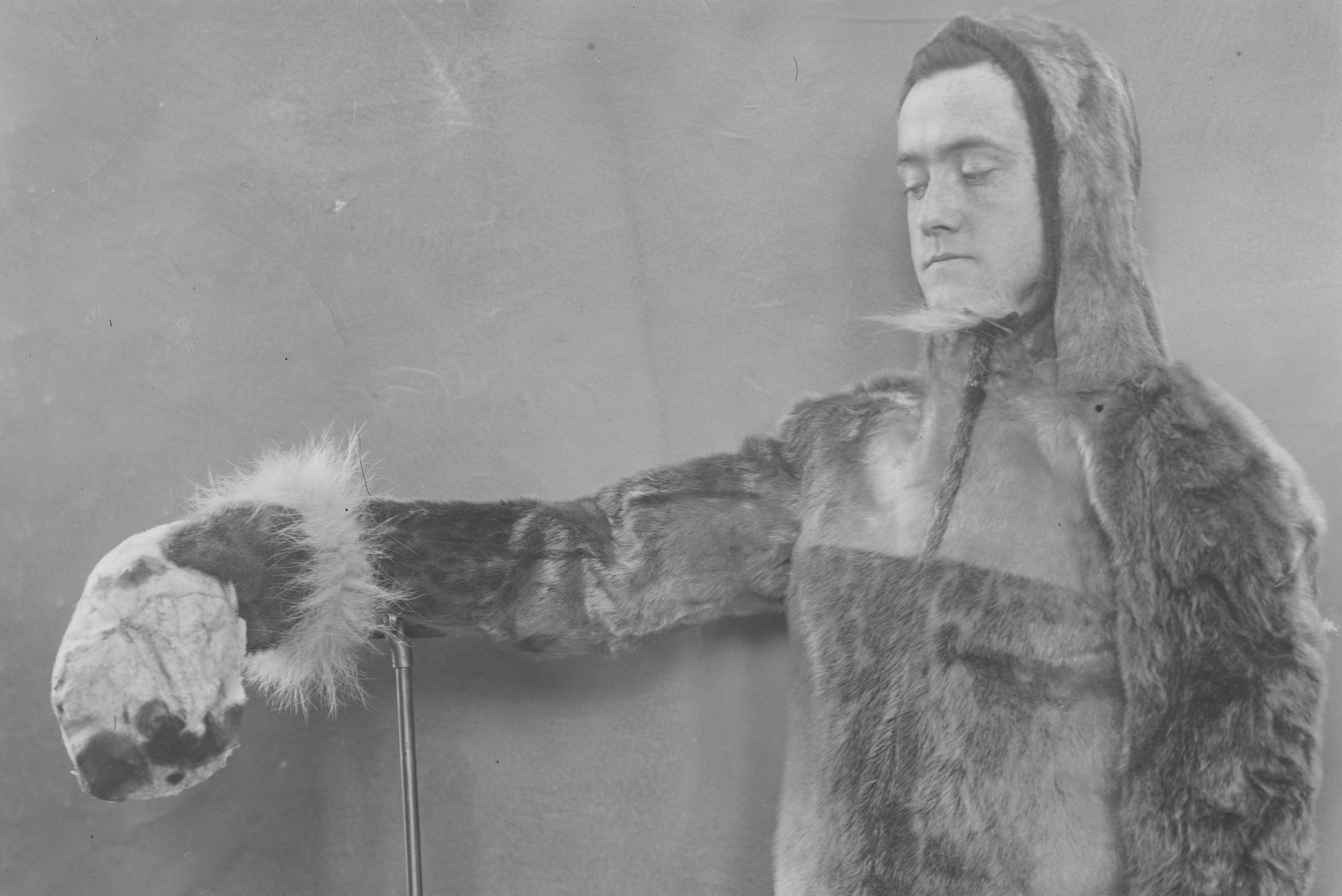
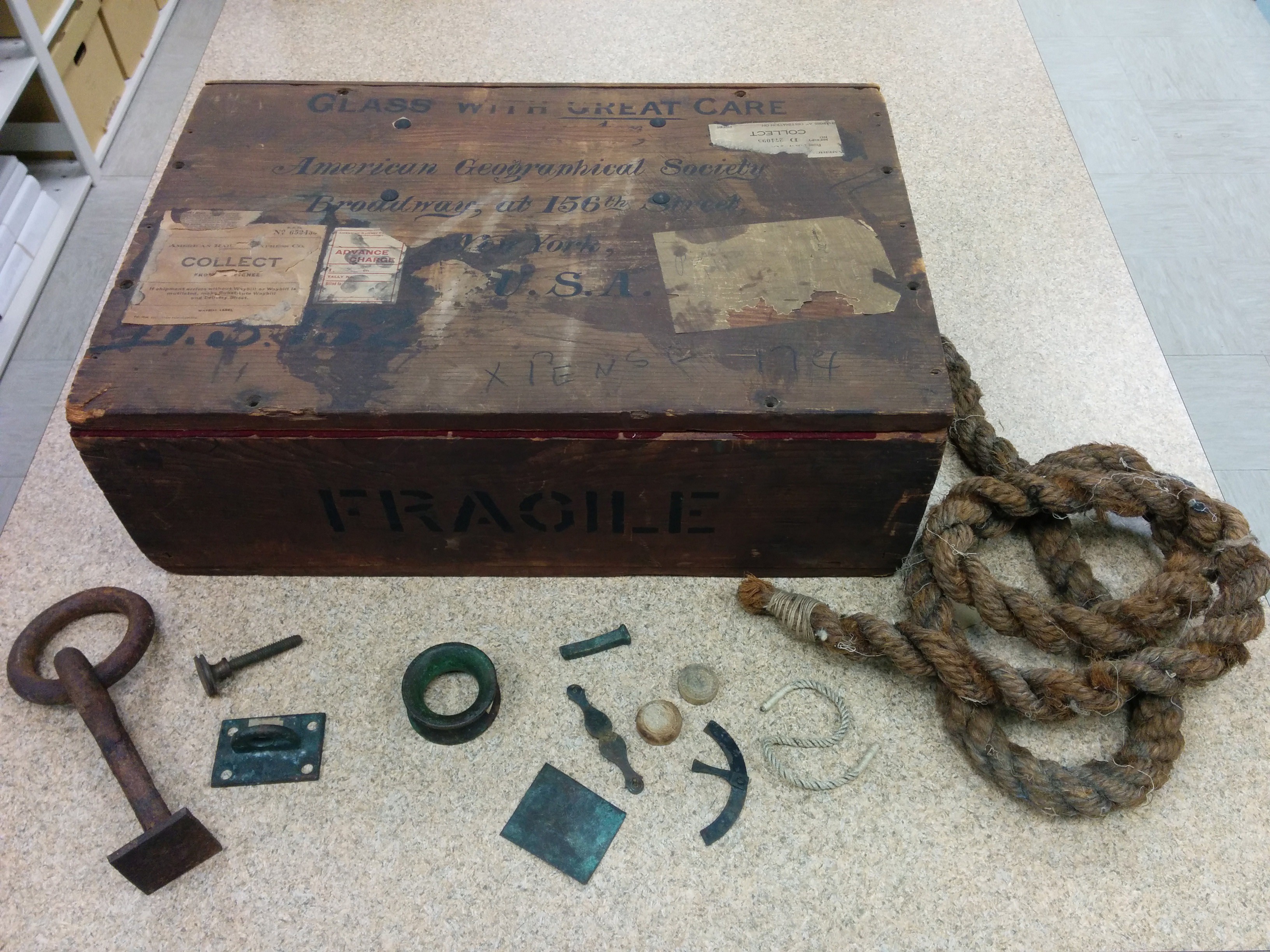
The expedition finally returned in 1917. As the AGS was one of the main sponsors of the expedition, the AGS-NY Archives at UW Milwaukee contains many of the records from it. These records provide much scientific data, helping to salvage something from the expedition. Included are geographical, mammalogical, and ornithological reports, along with meteorological and astronomical records. There is also a large wooden box, containing numerous artifacts from previous Arctic expeditions. Among these are items from Elisha Kent Kane and Robert Peary.
- ← Previous
- 1
- …
- 13
- 14
- 15
- Next →
