Archival Collections
October Pop-up Exhibit
By Lauren Maddox
Happy Halloween! This month, the AGSL, UWM Archives, and Special Collections collaborated on another Pop-Up Exhibit! The official exhibit ran from October 23rd-25th and included specially curated pieces such as wood engravings of Mary Shelley’s Frankenstein by Barry Moser and many more spooky, scary artifacts! Well, you may have missed the full Pop-up Exhibit but don’t despair! There’s still time to see the hair-raising picks put out by the AGSL for the pop-up– our exhibition materials will stay on display until after Halloween! Peruse our collection; you may find sea monsters, witches, and haunted cemeteries– and if that doesn’t scare you, stay tuned for next week’s post which will feature some of the most spine-chilling, blood-curdling maps from this month’s Pop-Up!

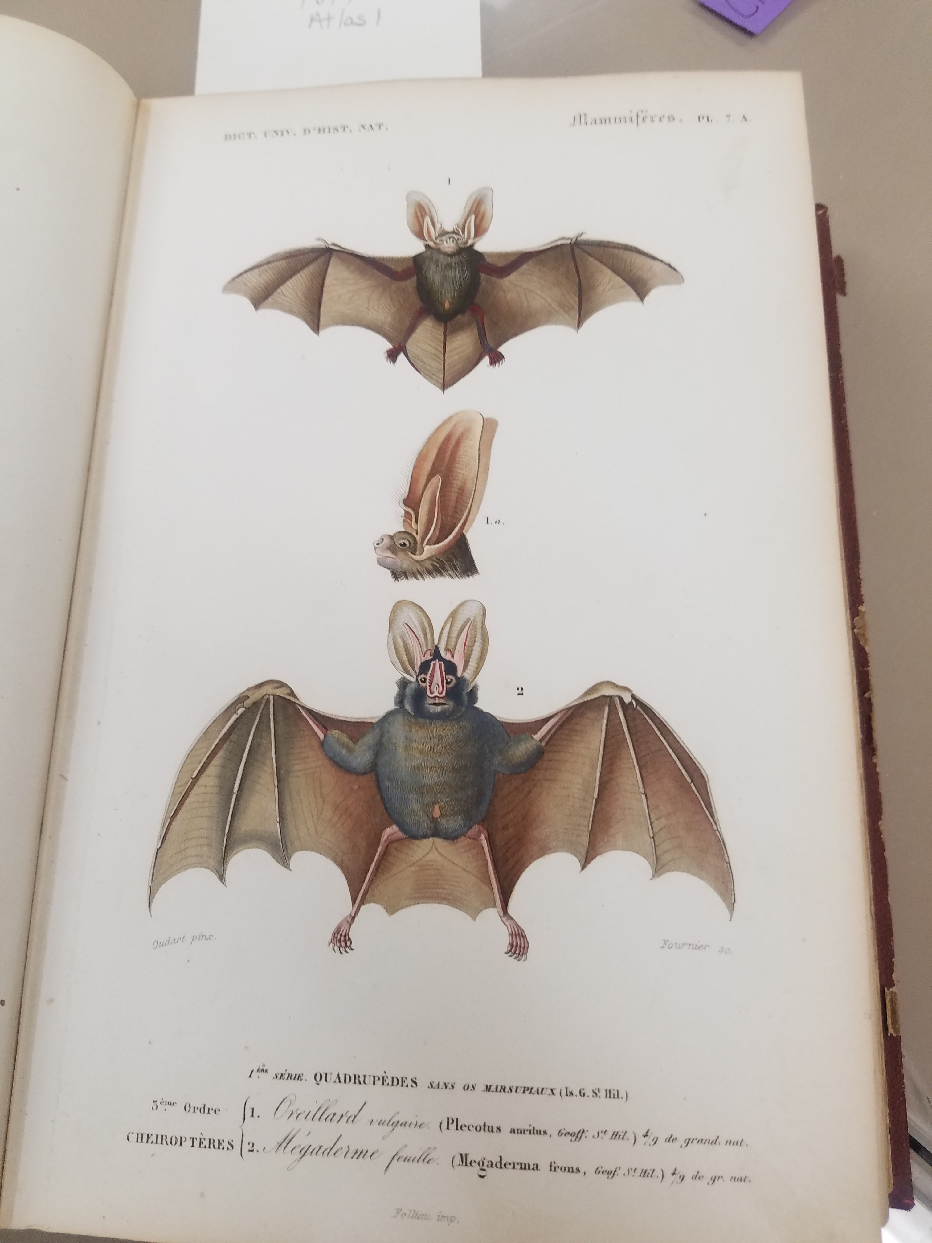
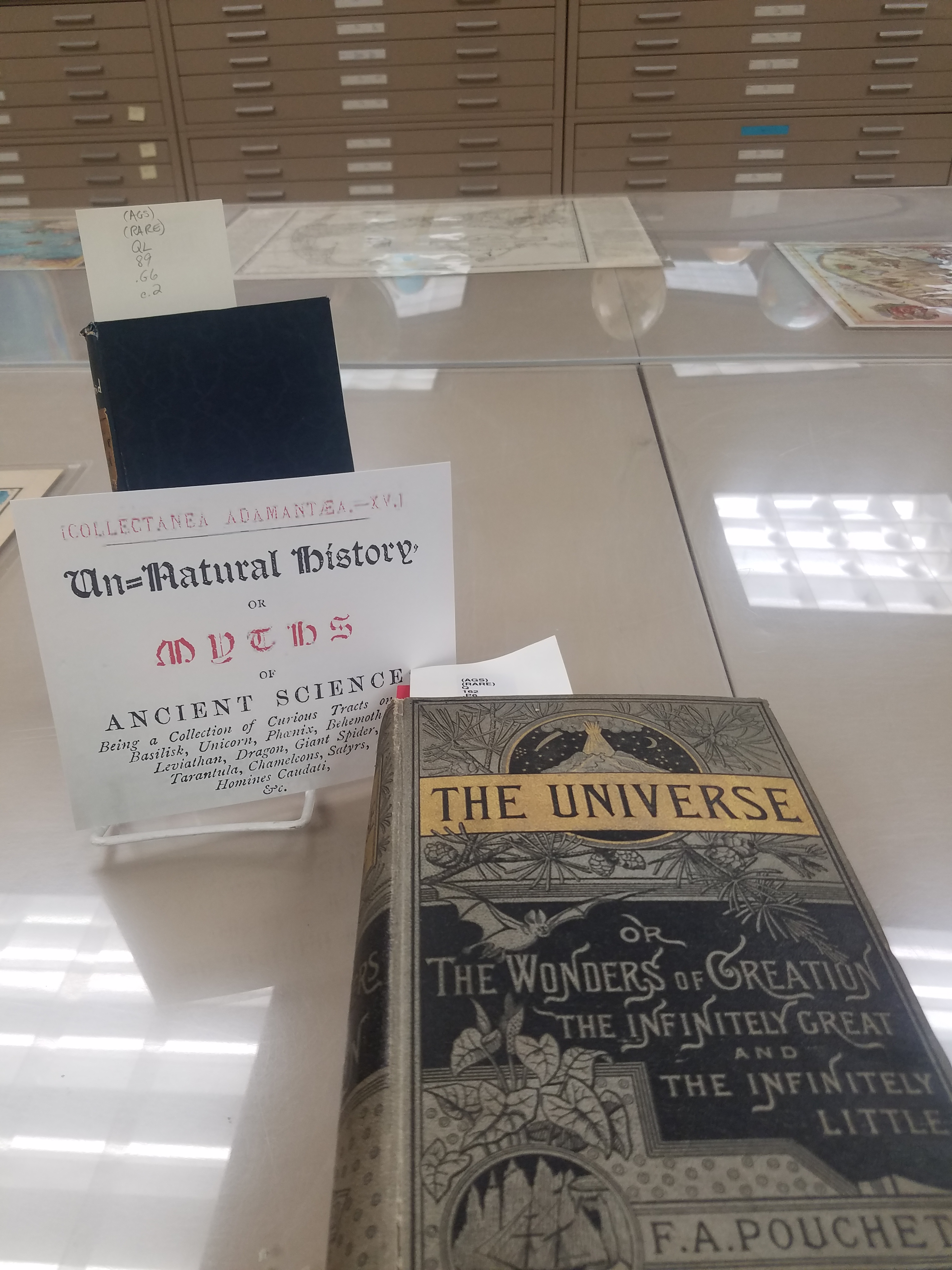
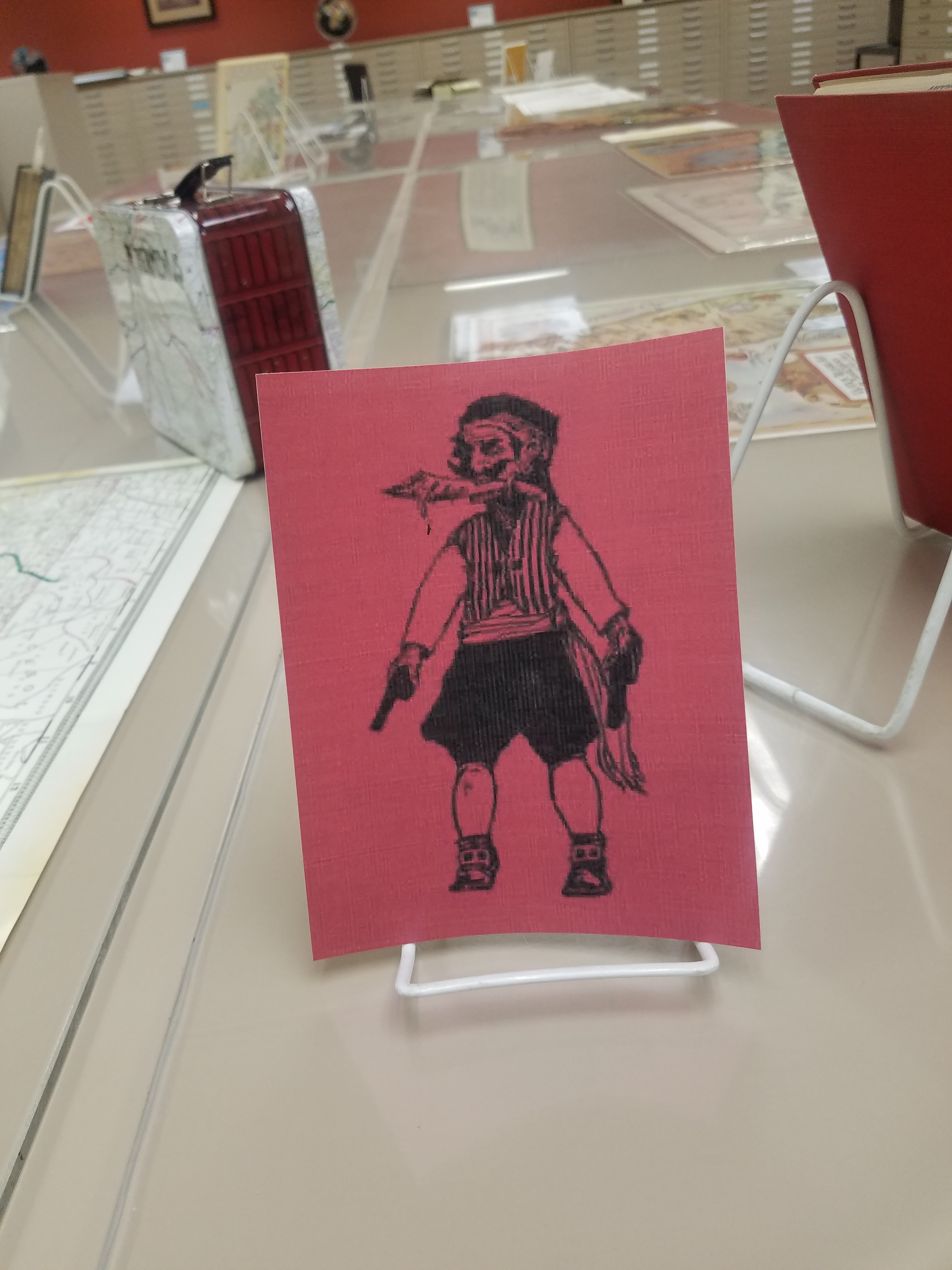
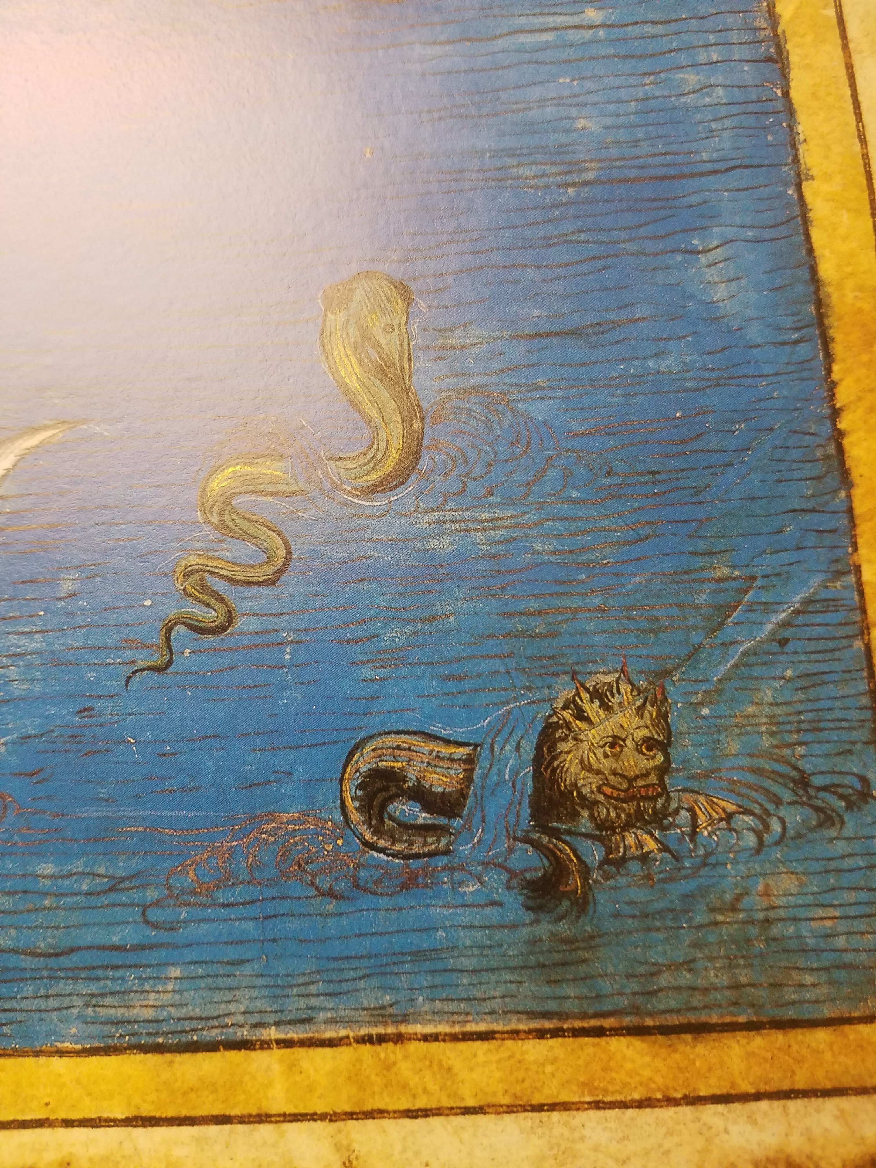
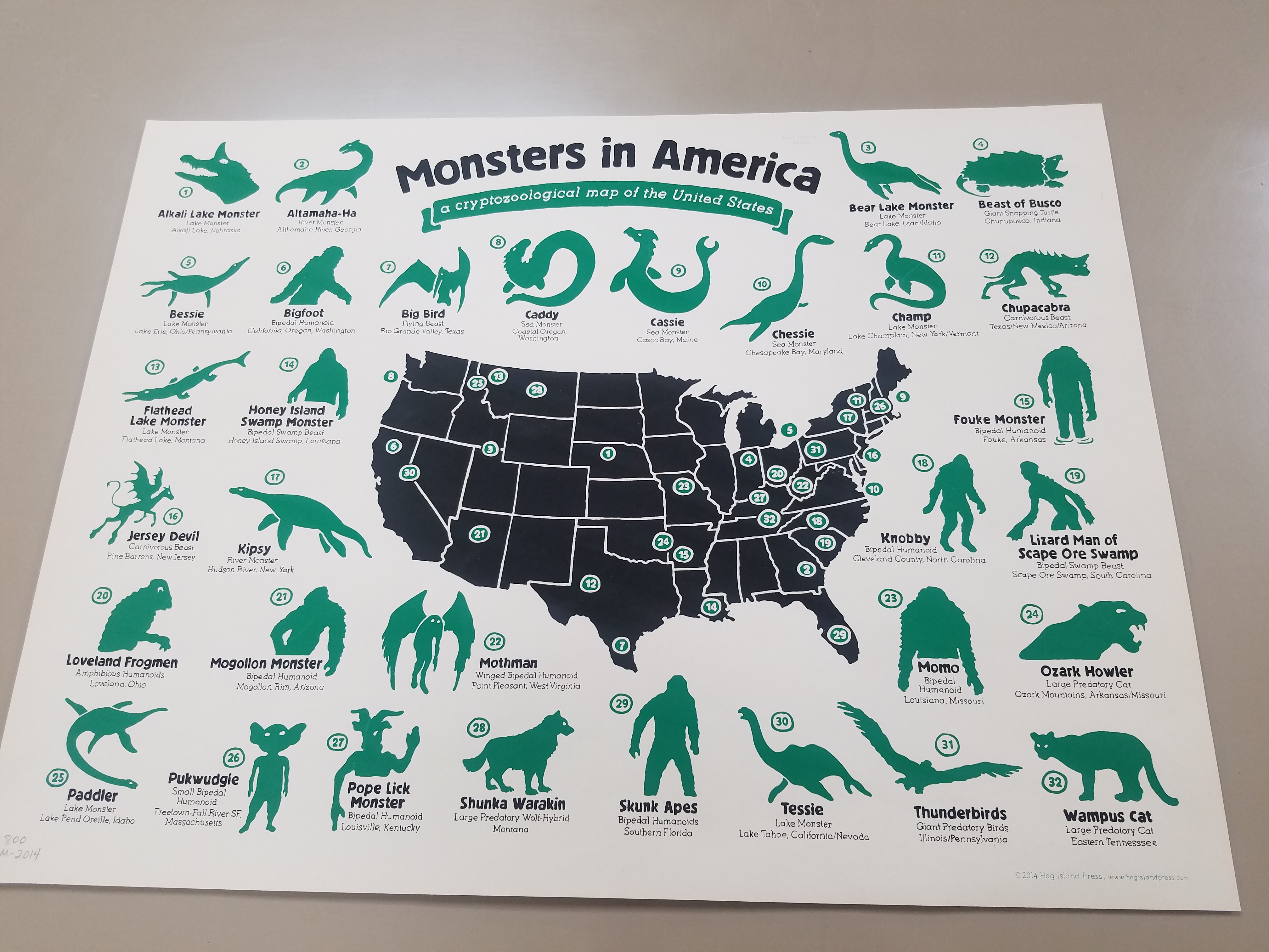
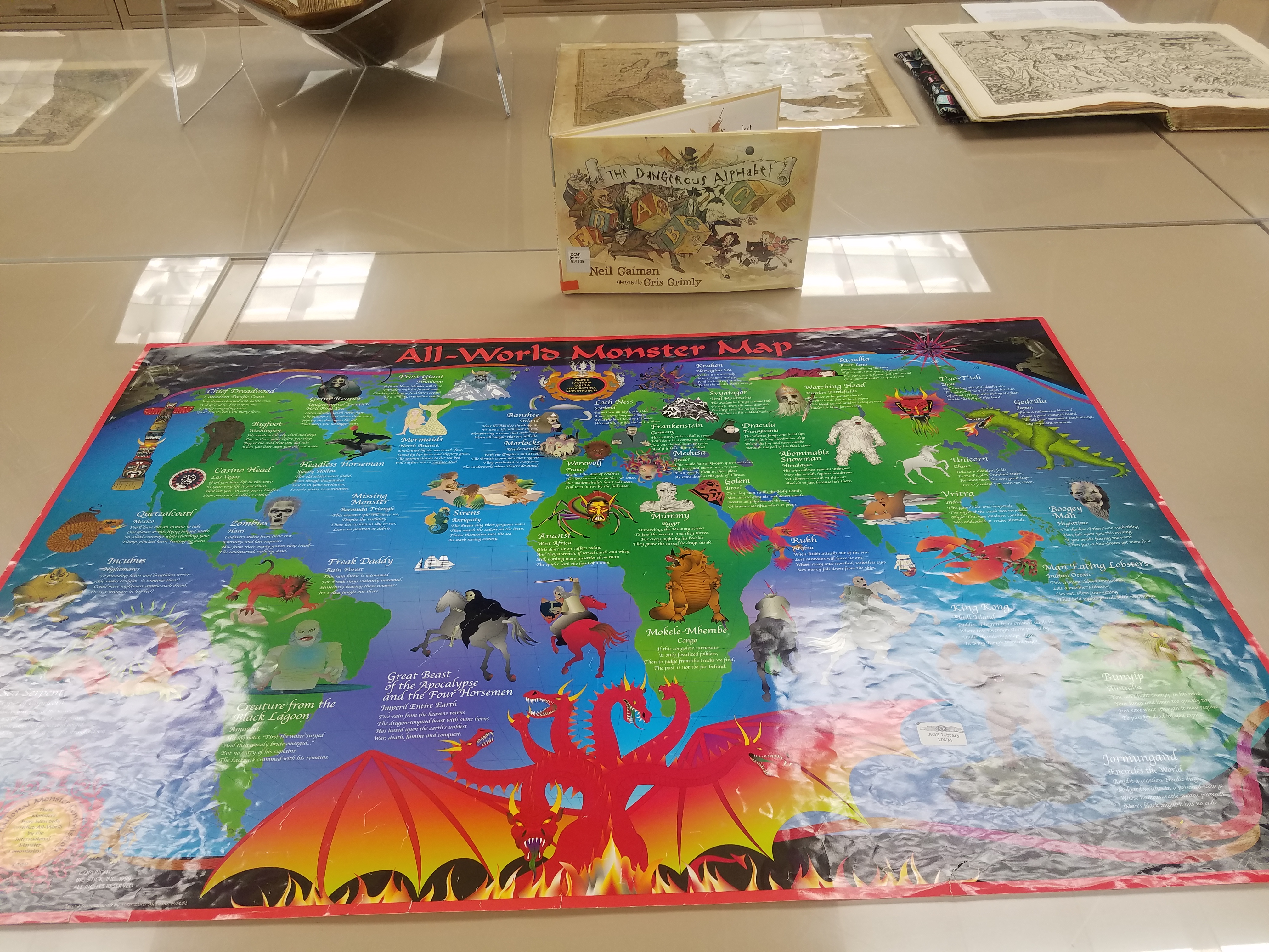
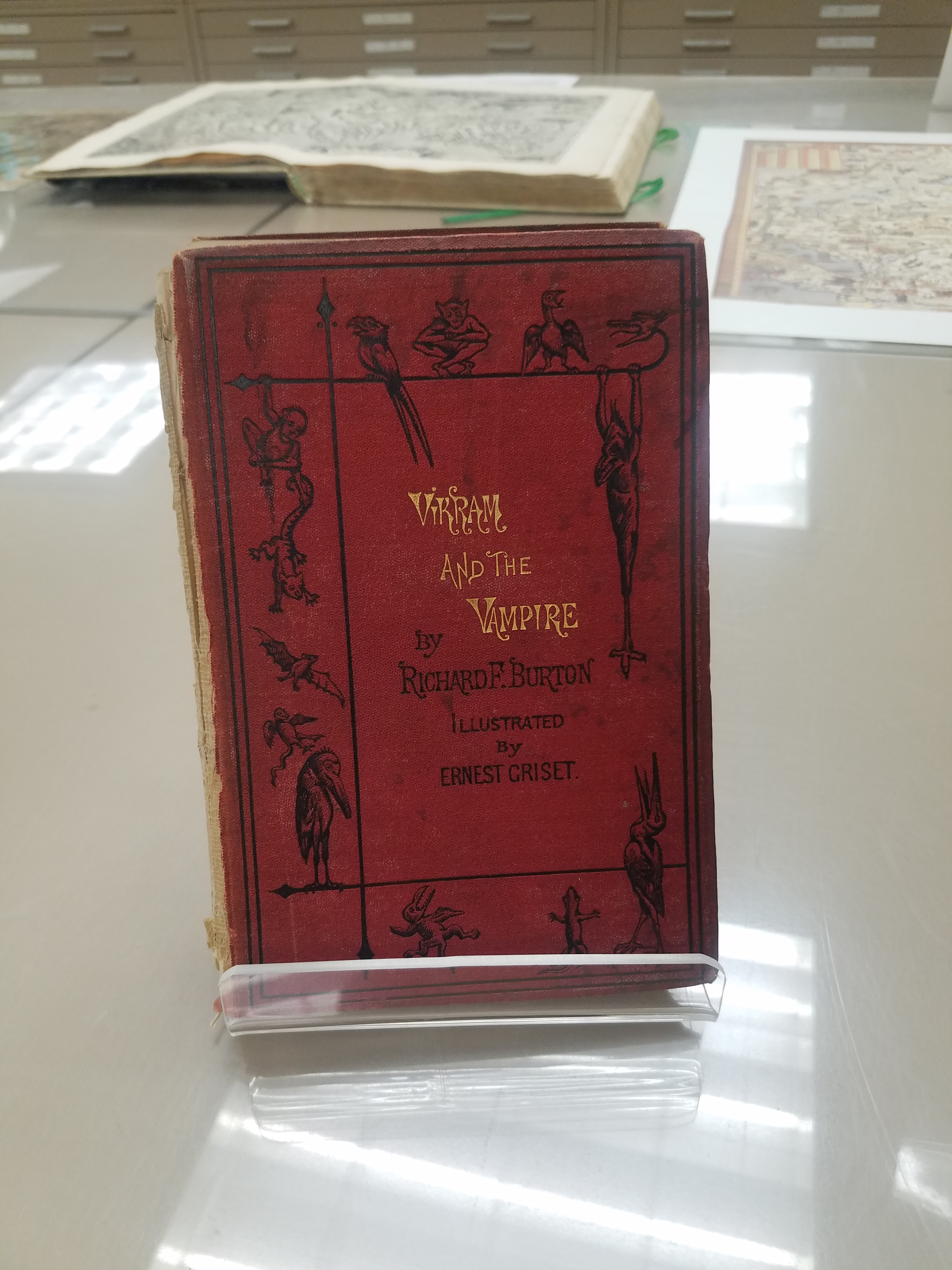
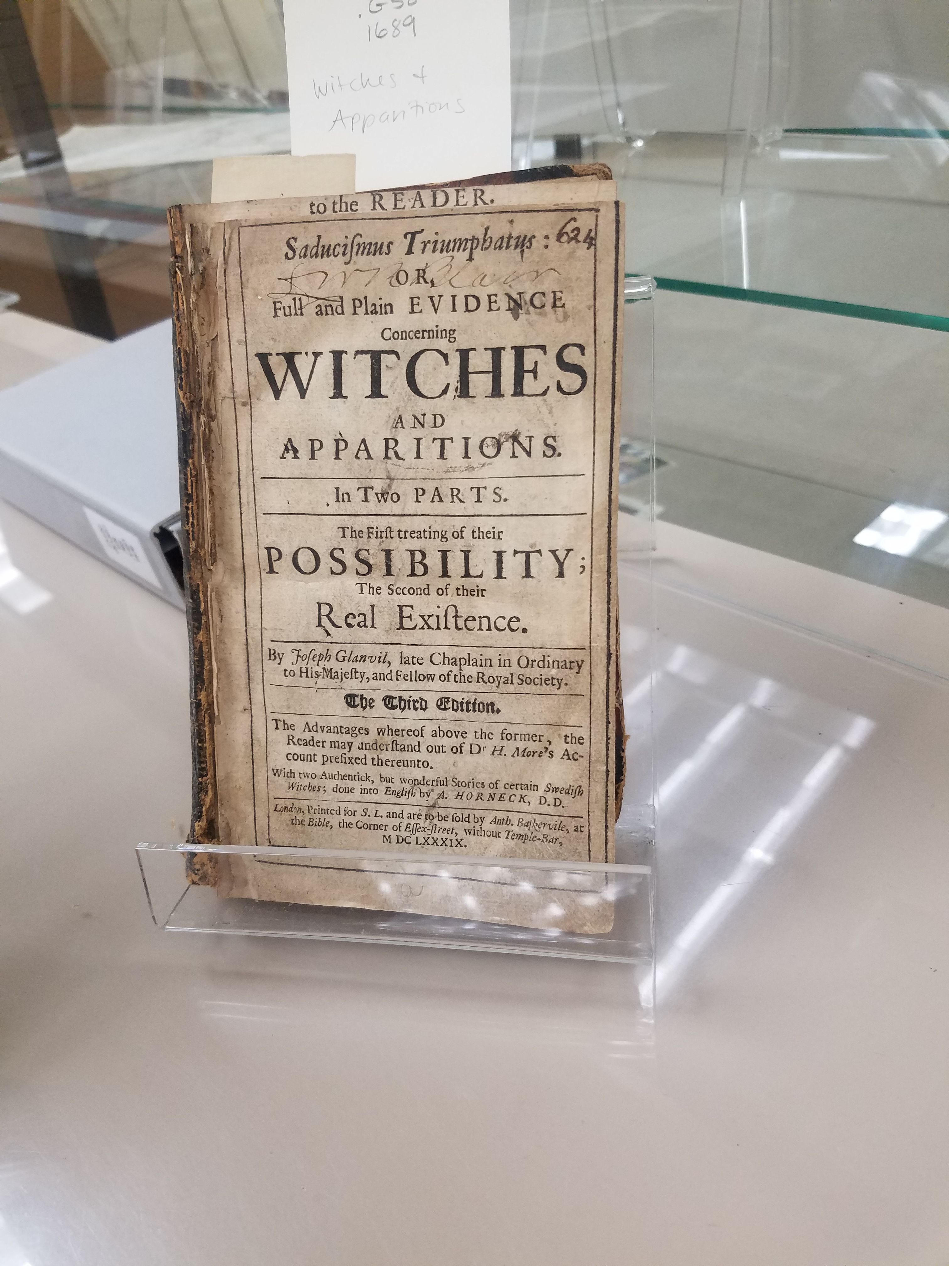
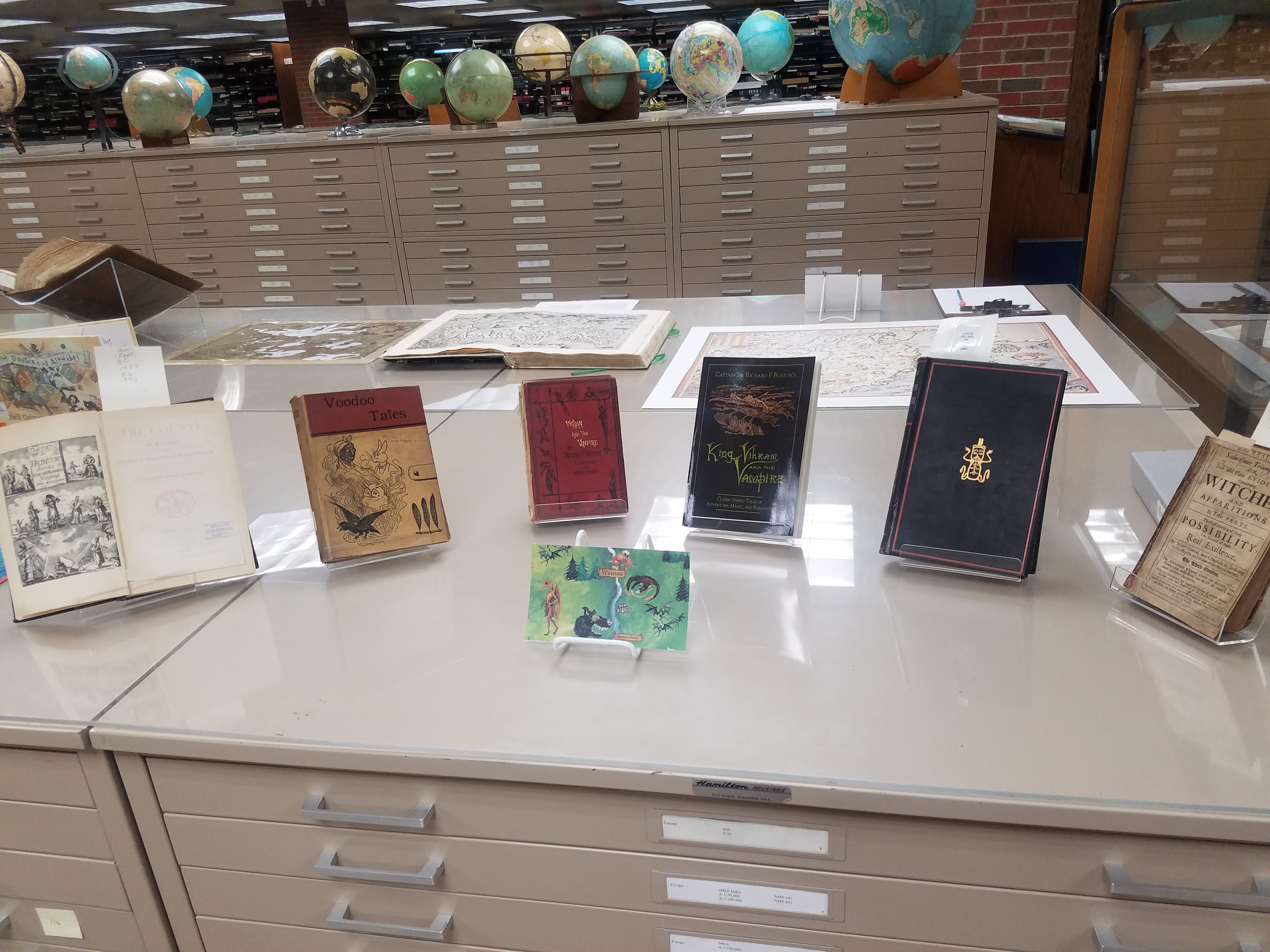
The AGSL is open to the public Monday through Friday, 8 a.m. to 4:30 p.m. Come see us and the Halloween Pop-up Exhibit while you still can!
In Case You Missed Us: The National Hispanic Heritage Month Pop-Up Exhibit
By Lauren Maddox
Last month, I wrote about our then-upcoming Pop-Up Exhibit in celebration of National Hispanic Heritage Month. The exhibit was a collaborative project in conjunction with the UWM Archives to showcase some of our collections and honor this very special month. As we move into October, we will be putting up another exciting exhibit (stay tuned for more on that later!), but in case you missed this pop-up, here are some of the digital versions of pieces we featured in the exhibit:
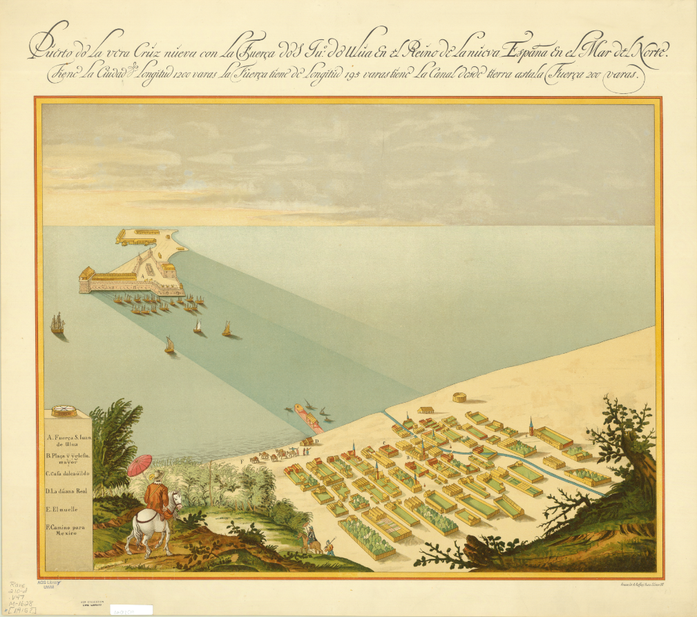
Map of San Juan Ulua Island in 1628. 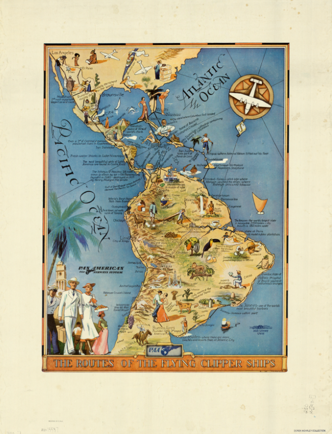
“The Routes of the Flying Clipper Ships,” 1930s. Click the links to see these maps in our Digital Collections! 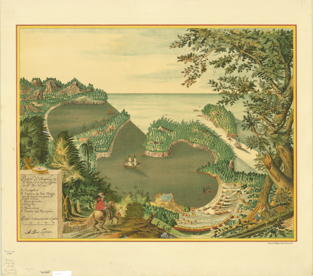
Map of San Juan Ulua Island in 1628. 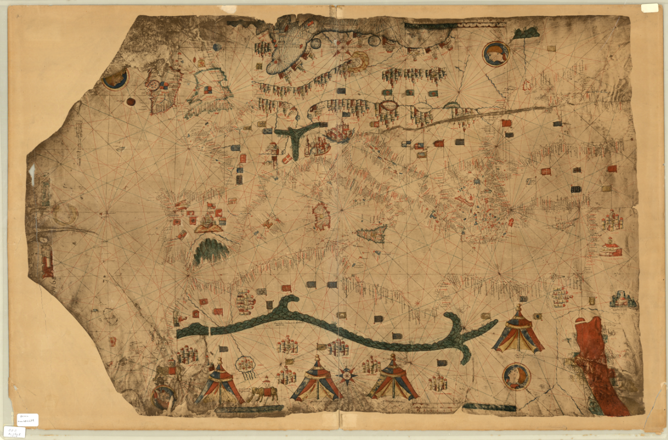
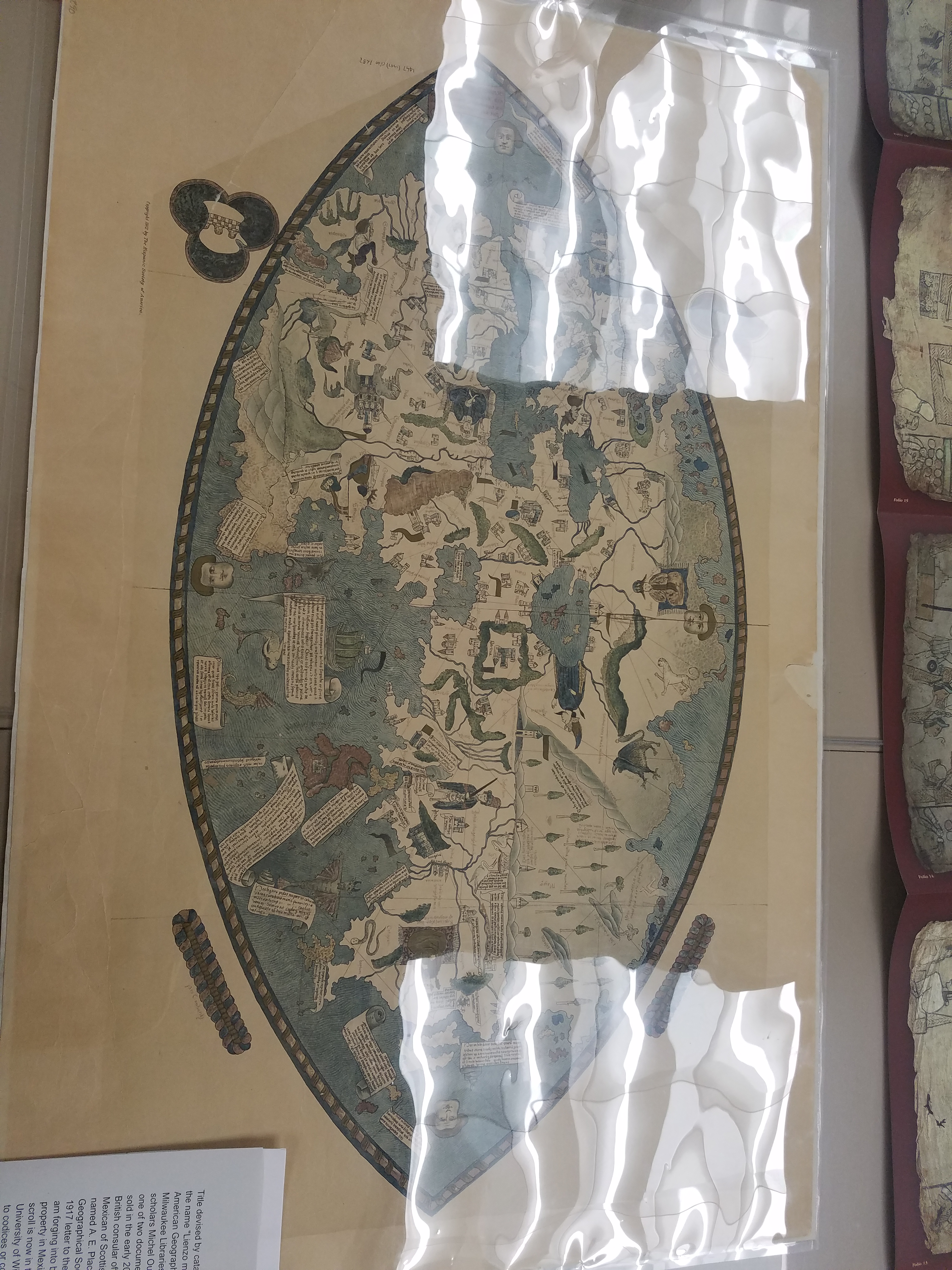
Fascimile of 1468 World Map, previously owned by the Hispanic Society of America.
And some photos of the exhibit live and in-person:
Stay tuned for more updates about future exhibits!
Fair and Square: A Short History of World’s Fairs
By Lauren Maddox

Unisphere Sculpture from 1964 New York World’s Fair, Taken by Harold Mayer. Click the link to see this photo in our Digital Collections!
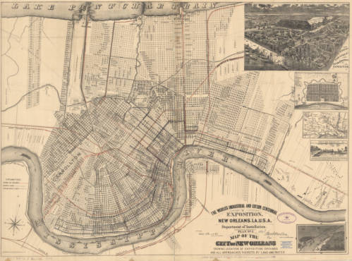
1884 Map of New Orleans’ Exposition Grounds. Click the link to see this map in our Digital Collections!
In 1984, Louisiana hosted a World’s Fair celebrating “The World of Rivers.” It was the last World’s Fair in the U.S. And it was the most financially disastrous fair in the history of World’s Fairs. To be fair, the point of hosting World’s Fairs and Expositions was never to make money– most host countries had to shell out exorbitant amounts of money to finance their fairs. But the point of the World’s Fair was never to make money; instead, these fairs were celebrations of progress and a chance to impress the international community. Host countries never expect to make a profit off of the Fair, but the 1984 Fair was particularly draining– it was the only Fair to ever go bankrupt.
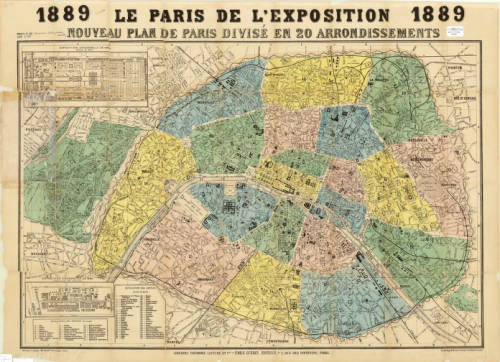
Map of Paris for the 1889 Exposition. Click the link to see this map in our Digital Collections!
But before the 1984 fair, the U.S. had a rich history as a member of the International Bureau of Exhibitions– they’ve hosted 30 World’s Fairs since their first in 1829. And before that?
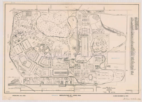
Ground Plan of Louisiana Purchase Exposition, 1904. Click the link to see this map in our Digital Collections!
The tradition of the World’s Fair is based heavily on French national expositions– but the first was actually hosted in Prague in 1791. This exposition was before World’s Fairs were standardized and regulated by the Bureau of International Expositions. These early expositions had their roots in Medieval festivals, and quickly became a way for post-revolution France to unite their new republic. The industry-focused expos continued under Napoleon but still focused on French products.
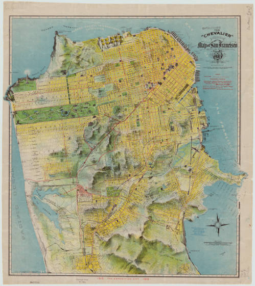
1912 Chevalier Map of San Francisco featuring the Panama-Pacific International Exposition grounds. Click the link to see this map in our Digital Collections!
The exposition most commonly cited as the first international affair is London’s Great Exposition in 1851. This World’s Fair was iconic– its great Crystal Palace became the symbol of World’s Fairs for years to come and continues to be one of the most quintessential Victorian structures.
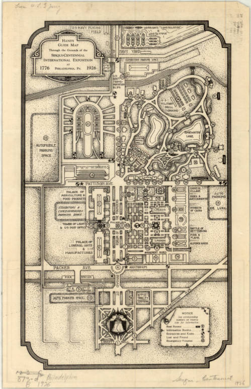
Complimentary Map of the Sesqui-Centennial International Exposition at Philadelphia, PA, 1926. Click the link to see this map in our Digital Collections! 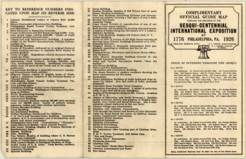
Points of Interest at the Sesqui-Centennial International Exposition at Philadelphia. Click the link to see this map in our Digital Collections!
In 1928, the Bureau of International Expositions (Bureau international des expositions) was established in order to oversee and approve of expo arrangements internationally and to set standards for expositions across nations. 170 countries are currently members of the BIE– including the United States. The BIE has remained in charge of international expositions ever since.
Map of the New York World’s Fair with Map of Greater New York’s Transit, 1939. Click the link to see this map in our Digital Collections! 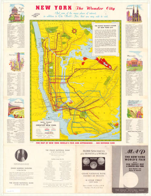
Map of New York Transit System with Points of Interest in the City, 1939. Click the link to see this map in our Digital Collections!
The nature of World’s Fairs have changed drastically since their Medieval beginnings– these fairs began as a way to unite communities, national and international, and then became an opportunity for countries to showcase their industrial prowess and establish themselves on the global stage.
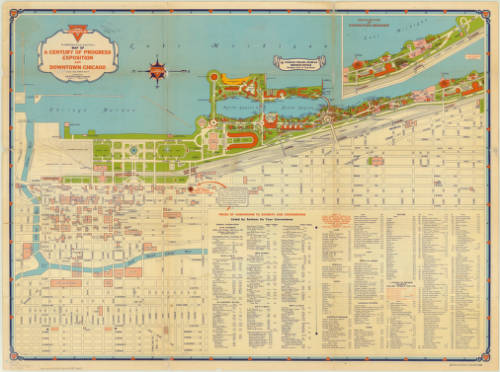
Map of Chicago’s 1933 World’s Fair. Click the link to see this map in our Digital Collections! 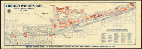
Map of Chicago’s 1934 World’s Fair. Click the link to see this map in our Digital Collections!
The 1984 exposition signaled the end of an era for World’s Fairs. It wasn’t just the last Fair to be hosted on American soil– it was also one of the first environmentally focused specialized expos. No longer are World’s Fairs an opportunity to flex wealth and status; instead, new expos are interested in environmentalism, building a sustainable future, and the building of a more united global community.
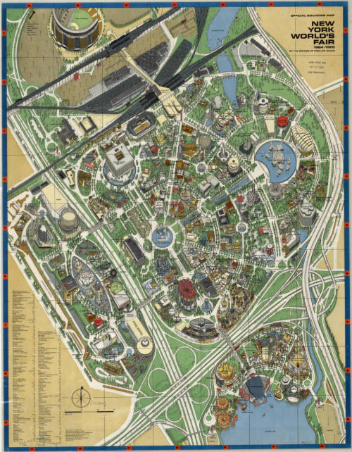
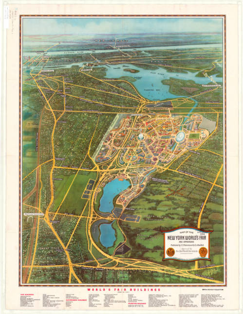
Map of New York’s 1964 World’s Fair. Click the link to see this map in our Digital Collections!
The United States withdrew membership from the BIE in 2002, but in 2017 rejoined. And maybe, in the near future, we can expect another Fair, as part of America’s long legacy of World’s Fairs, looking forward into a bright future.
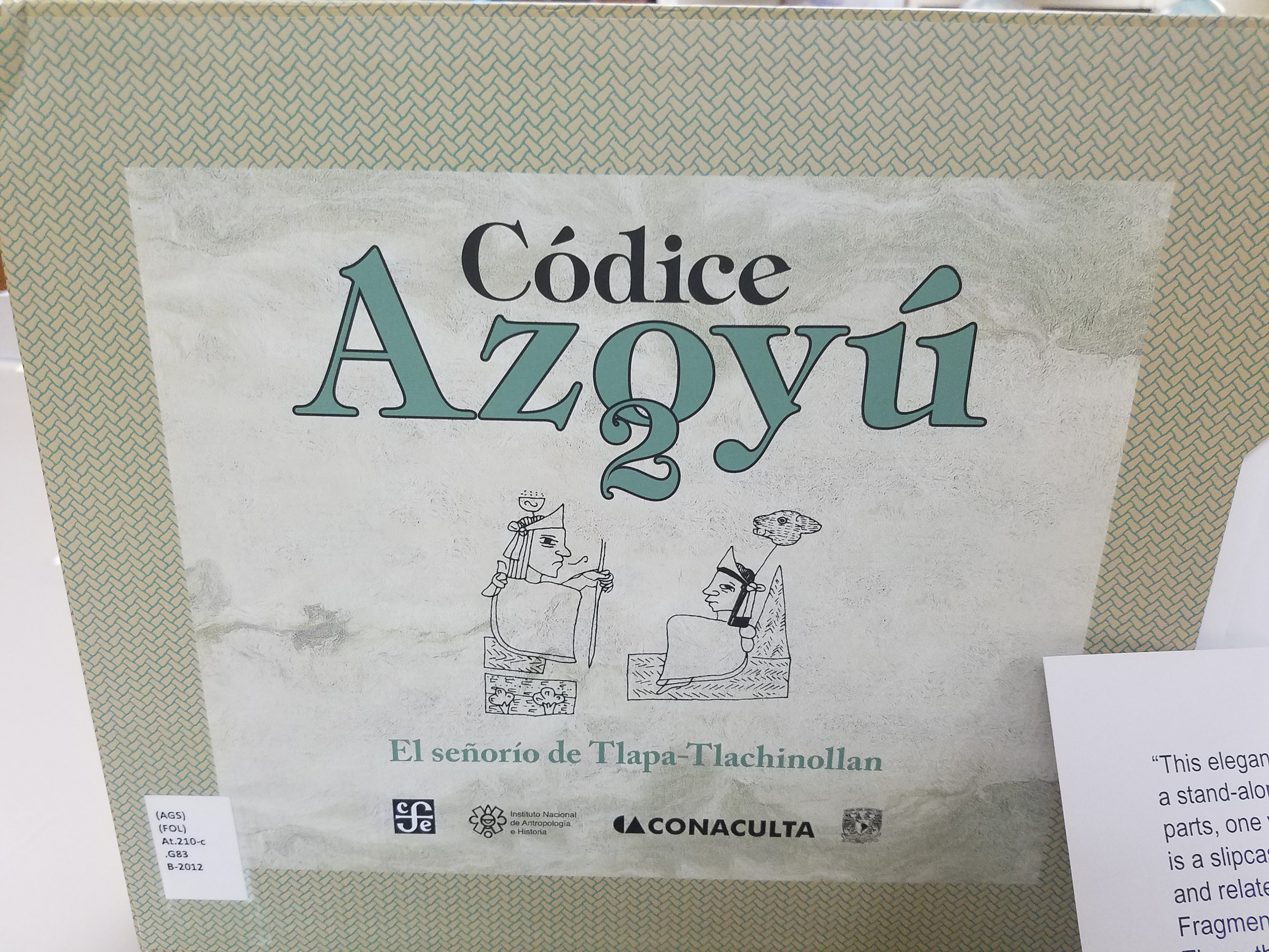
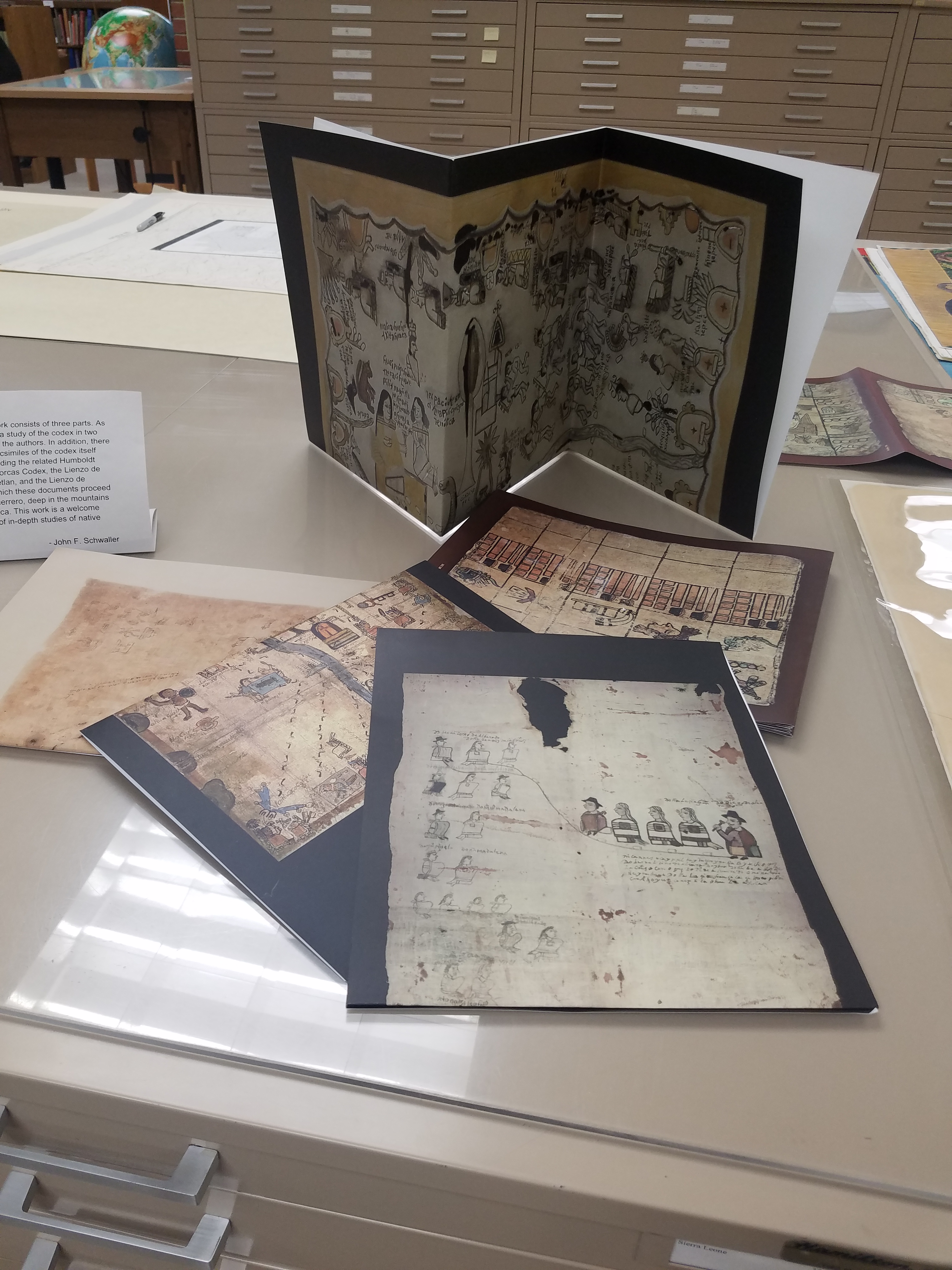
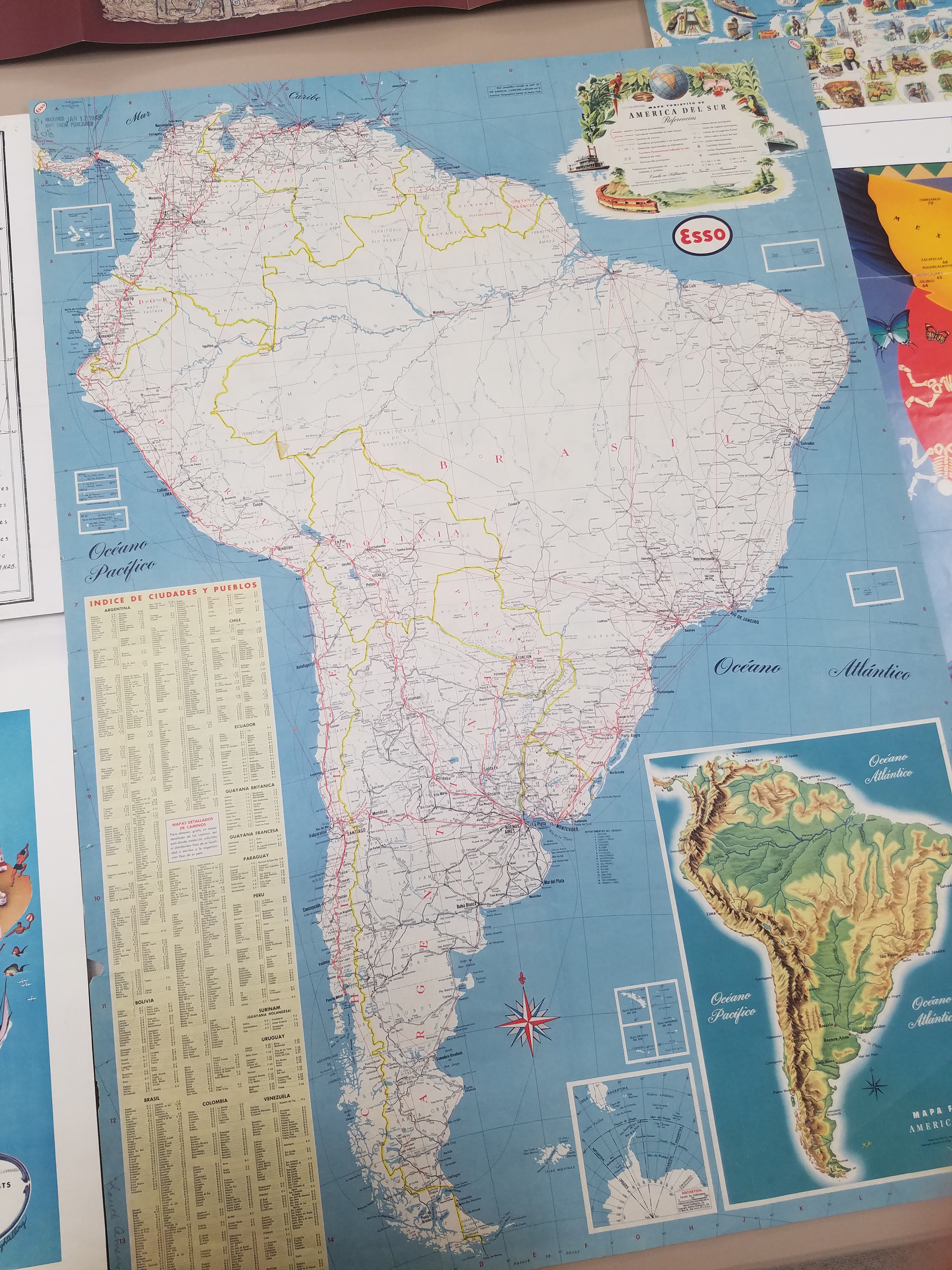
Hispanic Heritage Month: A Special Pop-Up Exhibit
By Lauren Maddox
This past Sunday marked the beginning of National Hispanic Heritage Month. This month is a celebration of Hispanic Americans who, according to the National Hispanic Heritage Month website, “have positively influenced and enriched our nation and society.” The tradition of a National Hispanic Heritage Month began in 1968, when Representative Edward R. Roybal sponsored legislation that would establish a National Hispanic Heritage Week. The holiday week was signed into effect under Lyndon B. Johnson and then expanded to a month-long period during Reagan’s presidency in 1988. The original start date, September 15th, was chosen to celebrate the official independence days of Costa Rica, El Salvador, Guatemala, Honduras, and Nicaragua declared in 1821. The original week also encompassed Mexico, Belize, and Chile’s independence days. Now the month-long observance, celebrated from September 15th-October 15th, includes all of these days as well as Dia de la Raza.
In honor of National Hispanic Heritage Month, many organizations including the Library of Congress, the National Gallery of Art, the Smithsonian, and the National Park Service are hosting events throughout September and October. Throughout the month, there will be a Community Day, a Hispanic Heritage Month Concert with Inca Son, a book talk with Haitian-American writer Edwidge Danticat, and a Wikipedia Edit-a-thon and more. And in addition to the live events, many digital archive collections are being made public this month– the National Hispanic Heritage Month website includes a list of all related exhibits and collections here. Some highlights from this list: the Library of Congress’s Archive of Hispanic Literature on Tape, Documents of 20th Century Latin American and Latino Art supported and hosted by the National Endowment for the Humanities, and many, many others.
But these aren’t the only ways to celebrate National Hispanic Heritage Month! This week from September 25-27th, the AGSL and UWM Archives are collaborating on a pop-up exhibit featuring curated pieces from both libraries’ collections. The exhibit will span both of our libraries: materials from the Archives will be on display on the second floor and maps from our collections will be exhibited in the AGSL. We are especially excited to showcase the Tira de Santa Catarina Ixtepeji scroll. Please, come celebrate this historic month with us! And enjoy a preview of some of the maps included in the exhibit:
Map of San Juan Ulua Island in 1628. Fascimile of 1468 World Map, previously owned by the Hispanic Society of America. Map of Acapulco in 1628. “The Routes of the Flying Clipper Ships,” 1930s. Click the links to see these maps in our Digital Collections!
The AGSL is open from 8:30-4:30 Monday-Friday! We will also be participating in Milwaukee Open Doors this weekend on September 28th from 10-5! Please stop by and see us!
The New Northwest Passage: Tourism through the Arctic
By Lauren Maddox
At the beginning of the summer, I did a series of posts discussing some of the AGSL’s connections to Arctic exploration and the famous explorers of that age (or, more accurately, the scandalous love lives of those explorers). But the Northwest Passage is still a part of the public’s romantic imagination– it’s a largely untraversable and unexplored wild full of cold beauty. And the fact that a Northwest Passage has been a geographical mystery for so many generations of Western explorers doesn’t hurt. As shrinking sea ice opens new routes through the storied Northwest Passage, more and more ships are passing through. Shipping freights are taking advantage of the new possible alternative to the Panama Canal for pan-oceanic travel– but in 2016, the first cruise ship passed through the Northwest Passage on a 28-day cruise through the Arctic.
The Northwest Passage has been the subject of years of conjecture and speculation for European travelers–there is even some evidence that Vikings traveled to the Arctic and traded with indigenous peoples before the Little Ice Age. Early attempts to discover a true Northwest Passage were spearheaded the English; Henry VII sent John Cabot on a search for a direct route to Asia that could be used for more open trading in 1497. Several later explorers followed suit: Estaban Gomez in 1524, Martin Frobisher in 1576, Humphrey Gilbert in 1583, and on and on into the next two centuries.
Explorers were also interested in finding alternative entry routes into the Passage– if they couldn’t traverse the Northwest Passage in its entirety, then maybe they could find another way onto the path. In 1539, Francisco De Ulloa embarked on an expedition to sail around the Baja California Peninsula– you might remember this from my July post about the island of California. Besides confirming the fact that California is indeed an island (just kidding), Ulloa also believed that the strait between California and the mainland would lead to an accessible Northwest Passage.
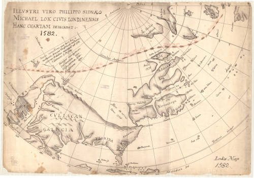
1776 Illustrative Map of the a proposed Northwest Passage through the Hudson Bay. Click the link to see this map in our digital collections! 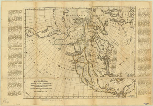
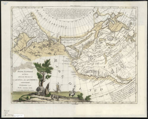
1770 Map of the Arctic, including a possible Northwest Passage. Click the link to see this map in our digital collections!
Many of these expeditions ended in tragedy– the truth was, at the time, there was no reliable pathway through the ice for ships to take. Routes that might be clear in one season would be completely frozen in another. Ships would often become stuck in the ice and forced to winter over where they were or abandon ship. In the 19th century, another rush of Arctic exploration swept Europe and the United States. In an earlier post, I go into some detail about the lost Franklin expedition and the scramble to discover their fate. This was one tragic ending of many expeditions– even Elisha Kent Kane’s rescue expedition in search of Franklin ended in a narrow escape from the deadly winter after which Kane’s health never recovered. Many thought that a purely ship-based expedition would never be possible; John Rae, the man who discovered the true fate of Franklin and his men, made many overland expeditions exploring the continent by using techniques already honed by native peoples who had managed to live there since, well, before the Vikings came to trade with them.
1860 Map of the Arctic Region. Click the link to see this map in our digital collection!
The Northwest Passage would prove impenetrable by ship until 1906, when Roald Amundsen and his six-person crew made a three-year journey through the icy waters in a tiny herring boat. His route through the Rae Strait was full of fairly young ice that was navigable and breakable, but the waters were shallow and only a small boat like the Gjøa could have made the trip.
As time passed and our climate has changed, the sea ice that prevented so many travelers from passing through the Northwest Passage has been shrinking. The Earth’s poles are more susceptible to the effects of climate change, and so the Arctic is warming at a faster rate than the rest of the world. The sea ice normally freezes and melts throughout the year, but the maximum coverage of the ice in winter has been shrinking at an alarming rate. This has some pretty huge implications for the state of our world, but has also led to an uptick in arctic tourism.
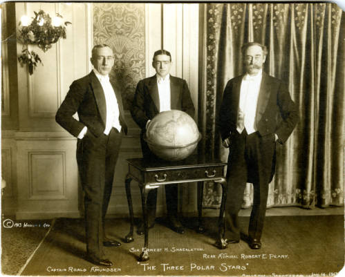
“The Three Polar Stars”: Photo of Amundsen, Shackleton, and Peary. Click the link to see this photo in our digital collection! 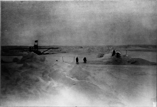
Amundsen’s 1925 Expedition with Ellsworth. Click the link to see this photo in our digital collections!
Because of the melting sea ice, larger boats can pass through the Northwest Passage. During the most recent Arthur Holzeimer Lecture at the AGSL, speaker Lauren Beck commented that, for the first time in history, the Northwest Passage of European imagination has become reality. Only because of the quickly degrading sea ice is the Northwest Passage actually a traversable ship passage.
Amundsen’s successful trip through the Northwest Passage did not turn it into an icy thoroughfare– the ice was still too much of a problem for large cargo ships and the water often dangerously shallow. In 2012, two astonishing events happened: arctic sea ice hit record lows, and ship passage through the Northwest Passage hit record highs. The Panama-Canal was still the better, more consistent choice for trans-ocean shipments, but the new open waterways inspired a different kind of ship-traffic.
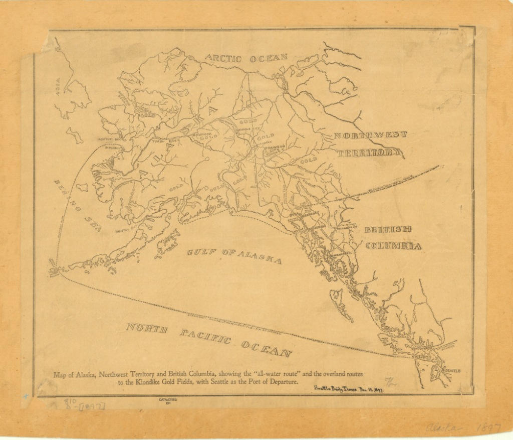
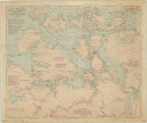
1897 Map of Alaska, Northwest Territory and British Columbia. Click the link to see this in our digital collections!
In 2016, the Crystal Serenity made an unprecedented voyage through the Northwest Passage; though not the first, it was the largest cruise ship to ever pass through the Northwest Passage. The cruise ship had to be escorted by a Polar-Grade ship that could break the ice for the cruise ship to pass though– or perform a rescue. While Crystal Cruises proudly took the Serenity through the Northwest Passage on multiple voyages for “true explore[s]” and is expecting the delivery of a Polar-Grade ship for more cruises, there is some concern about what tourism in the Arctic really means.
For one thing, the communities living there don’t have the infrastructure to deal with the influx of people and garbage. Townships are overwhelmed even by limited groups of tourists visiting. And the effect that human interference has on local flora and fauna– never mind the impending catastrophic oil or fuel spill that seems inevitable with increased traffic– can have deadly consequences for local indigenous communities.
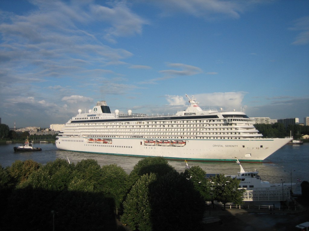
Photo of the Crystal Serenity in Antwerp
For many people, Arctic tourism is a “last-chance” to see an environment that might be on the brink of destruction. And while it is true that experiencing the Arctic has inspired many to defend it from climate destruction, the increased number of ships creates an increased risk of disaster for the environment, the people who live there, and even the tourists themselves. But ignoring the real possibility of climate disaster (or a shipwreck stranding hundreds of tourists on the Arctic Ocean), Arctic tourism also has a troubling philosophical component. Last-chance tourism forces us to think about the destruction of our natural world and how we want to face it. Do we want to put it at potential risk for the chance that tourists become potential activists? Or do we protect it from commercial interference as long as possible?
The answers to these questions are unclear, but as the Arctic tourism industry grows, the search for answers becomes more urgent.
Shelf Read Week
By Lauren Maddox
Thank you all for your patience during our brief hiatus last month! The AGSL has been preparing for the start of the new school year, which included a collection-wide shelf read. The shelf read will actually be an on-going project; each staff member will spend an hour a week continuing to read their section. But last week we came together as a staff to try and tackle the bulk of the work before students came back to campus for the Fall semester.
Most of my time at the AGSL this summer has been spent at my desk. Before I started writing for the AGSL, I had pretty much no experience working in libraries. Well, I was technically a library assistant at my high school, but that just meant I spent every morning reading in the library. So, I was pretty excited to get on board with the rest of the staff and do some real down-and-dirty library work.
Conclusions: I escaped with 0 paper cuts and the knowledge that it’s very hard for me to count past 64. But I thought that this would be a great opportunity for our readers to get an inside look at some of the behind the scenes work our staff does to make sure our library is as accessible and useful to our patrons as possible!
I was assigned sections 050-b and 200-b through c, which included the entire Carta Topagraphia. This was the point at which I realized I couldn’t count past 64, by the way– almost every map folder in this collection had close to 100 maps in it.
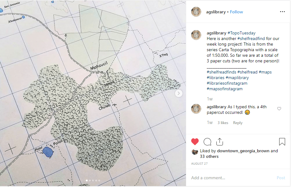
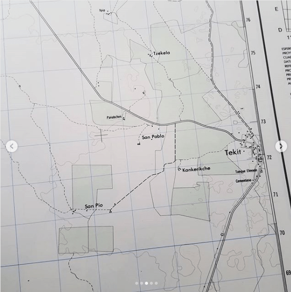
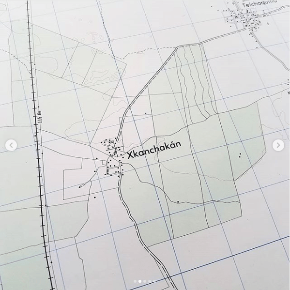
For this shelf-read, there were a few specific tasks we wanted to take care of specifically. First, we counted the maps in each folder; those individual counts were combined into a cumulative total. The shelf-read put into perspective just how many items are in the AGSL’s collections– I counted a couple thousand all by myself! Which was not the highest score. Our cumulative total of maps counted that week was 46, 709. And we’ve only just begun! Then, it was important to make sure that the maps that were in each folder were supposed to be there and in the right order. And we also worked on relabeling folders for ease-of-access for the future. And we stayed on the lookout for interesting maps that hadn’t been scanned yet to add to our digital collection or maps that hadn’t been cataloged officially. To keep spirits bright (because, no matter how necessary, counting map sheets is never going to be anyone’s favorite pastime) we also had a game of Shelf-Read Bingo going all week. I came in second place.
If, when you visit us during the semester, you notice that someone is shelf-reading, know that you’re witnessing a large-scale, on-going project that our whole staff is working on! And maybe let them finish counting– or else they might get stuck at 64 and have to start over.
Imperial Russian Black Sea Atlas at the AGSL Part II
By Josephine Miller
Black Sea Atlas
The atlas became a significant work. It would be used by the Russian military for the next 30 years.[1] Manganari’s nautical charts were used as a base for the later editions published by the Imperial Navy. Even the Soviets used Manganari’s charts as a base in the 1920s, about eighty years after the original atlas was published. These later editions are held by the AGS Library. In the AGS Library’s possession are Black Sea and Azov nautical charts that date from the 1880s to the 1920s. Illustrations and corrections were added to later editions. These illustrations include lighthouses, large buildings, sea marks, and day marks to facilitate navigation. Newer measurements of compass declination were also added. However, much of the original Manganari charts remained in the later editions. His drawing of the coastlines, topography, and bathymetry remained as a base for future editions into the early Soviet era. The soil reports given from his nautical charts remained as well. Additionally, the map scales were kept in later editions.
As for the coastlines of the nautical charts, they were drawn according to astronomical and trigonometric calculations. This can be seen virtually all of the nautical charts of the Black Sea Atlas:

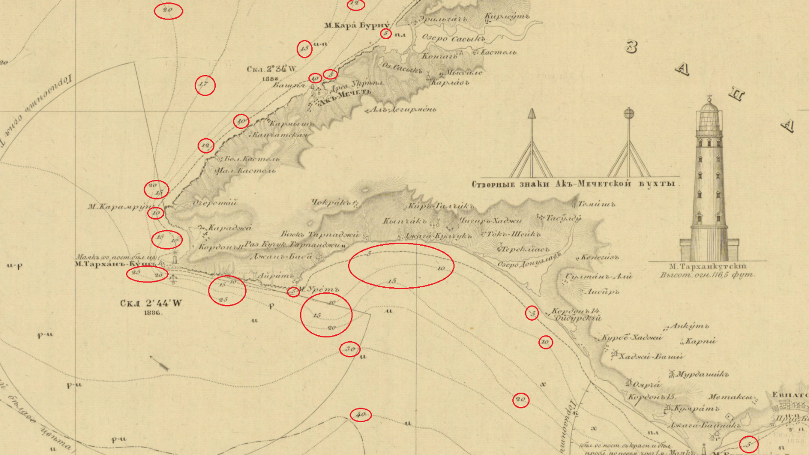
“Shore is determined by trigonometric means and many astronomical observations.” From Карта Части Сѣвернаго Берега Черного Моря отъ Одессы до Мыса Херсонеса (A Map of Northern Black Sea Coast, Odessa to Cape Chersonesos). Click the link to see the entire map!
Navigational routes, drawn as sea lanes, are essential to nautical charts. To aide navigation, landmarks and seamarks are given. Manganari plotted different kinds of lines to indicate valuable information for navigation. Each chart in the atlas has almost identical legends in regards to navigation. However, there is slight variations between charts due to mountains or cultural landmarks. These cultural landmarks are usually religious, such as churches and mosques. Here is the legend from the 1891 edition of the Northern Black Sea Coast.
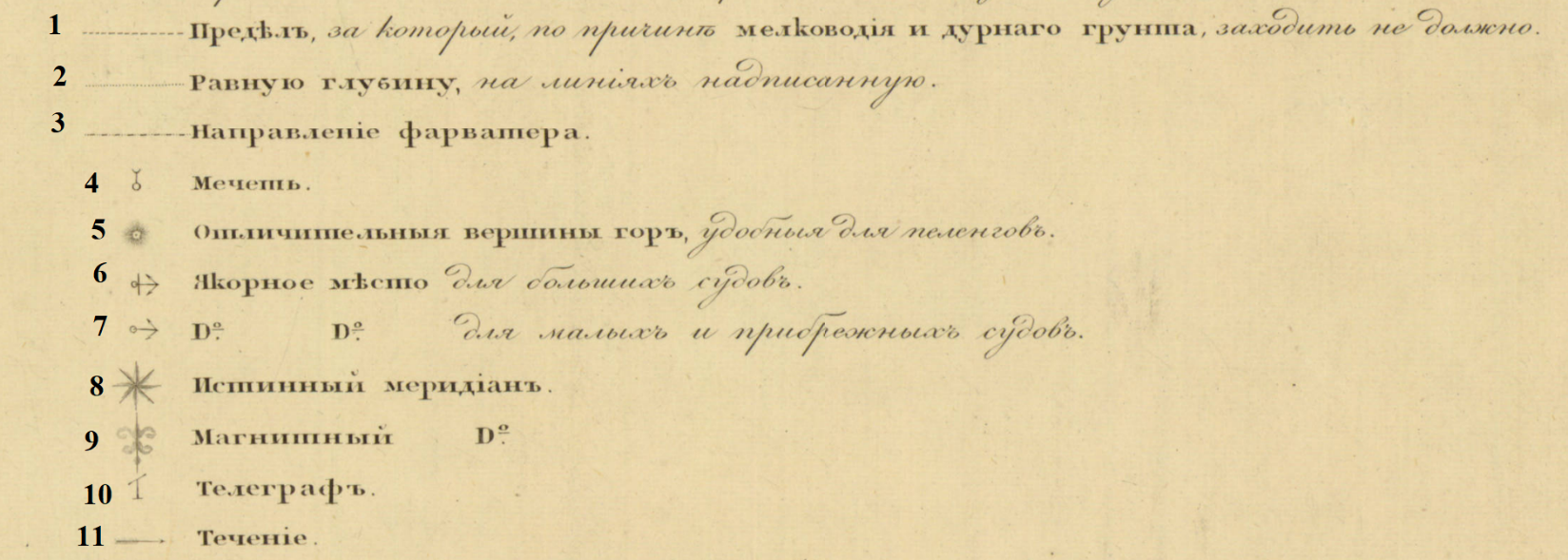
1. The limit for which, due to shallow water and bad soil, should not enter. 2. Equal depths on the plotted line. 3. Direction of fairway. 4. Mosque. 5. Distinctive mountain peaks, convenient for bearing. 6. Anchor place for large ships. 7. Anchor place for small and coastal ships. 8. True Meridian. 9. Magnetic Meridian. 10. Telegraph 11. Tide or Current.
One area of British influence in Russian cartography is measurement. A larger than life ruler, the impact of Peter the Great carried long after his death. His reign is reflected in the field of Russian cartography. Inspired by his tour of the West, he established in the Imperial Navy in 1696. Peter’s command to westernize Russian government brought Western cartography to Russia, military largely in mind. One major reform was to implement British measurements for military use. Consequently, almost two centuries later, the Russian Navy used the British Imperial measurements in its nautical charts. This can be seen on the AGSL’s charts. The Imperial measurements were used for distance and depth.
On this 1891 edition nautical chart of the northern Black Sea coast, the map scale uses British measurements:
On this 1891 edition nautical chart of the northern Black Sea coast, the map scale uses British measurements:

Map Scale of Карта Части Сѣвернаго Берега Черного Моря отъ Одессы до Мыса Херсонеса [Northern Black Sea Coast, Odessa to Cape Chersonesos].

Another example of British measurments is found on the same chart, depth.
“Depth of sea height measured in six-foot English fathoms – rivers and estuaries in feet.”
Circled below are the depth marks.
From Карта Части Сѣвернаго Берега Черного Моря отъ Одессы до Мыса Херсонеса (Northern Black Sea Coast, Odessa to Cape Chersonesos). Click the link to see this map in our Digital Collections!
In addition to depth, Managanari recorded the soils of the sea floor.
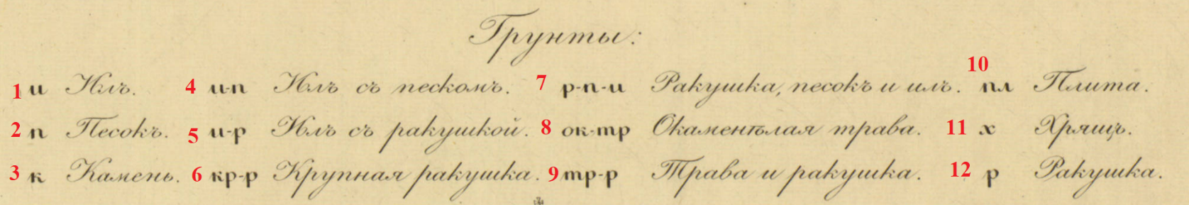
Карта Части Сѣвернаго Берега Черного Моря отъ Одессы до Мыса Херсонеса (Northern Black Sea Coast, Odessa to Cape Chersonesos). Click the link to see the whole map in our Digital Collections!
- Silt
- Sand
- Rock
- Silt with sand
- Silt with shells
- Large Shell
- Shell, sand in silt
- Petrified weeds
- Weeds and shells
- Plate
- Cartilage or Gristle
- Shells
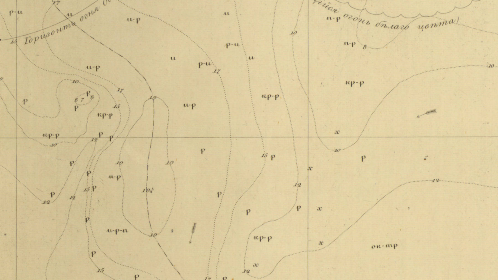
Sea floor on the chart. The letters represent soils as indicated by the legend.
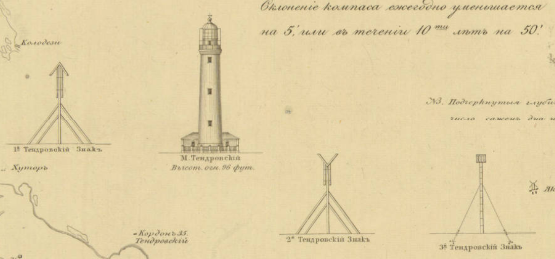
Later editions published after the Treaty of London (1870) include lighthouses and seamarks. Here is the Lighthouse of Tendra Bay on the Southwestern coast of Ukraine. It is noted as 96 feet. Beside it are seamarks. These landmarks aide navigation.
A significant factor to navigation is the prime meridian. In the early 19th century, the Russian militray did not use Greenwich as the prime meridian for its cartography. Instead, Manganari used the Pulkovo Meridian as the prime meridian, which was the practice in Russia at the time. The Pulkovo meridian is located at the Pulkovo Observatory in Saint Petersburg. In the spirit of the reforms in Alexander’s II reign, the later editions adopted Greenwich.

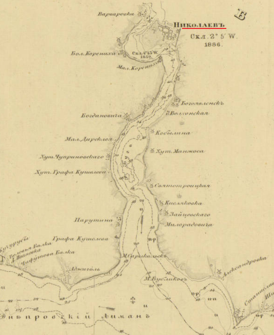
Nikolayev was a base of the Black Sea Fleet. It was also the location of the Depot of the Hydrographic Department of the Black Sea Fleet for the Imperial Navy. In1803, the depot was founded at the request of the Marquis de Traverse, Commander-in-Chief of the Black Sea Fleet at the time. It was established for the engineering needs of the fleet. There, the nautical charts of the Black Sea Atlas were drawn and compiled before engraving. Later editions of the charts were published in Nikolayev. [2]
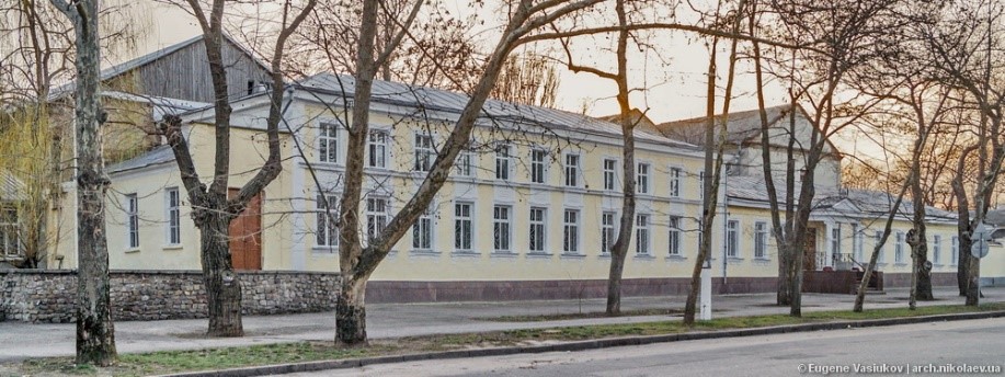
Map Depot of the Hydrographic Department, Black Sea Fleet, Imperial Russian Navy, Nikolyaev. Click the link to learn more!
Later editions borrow from Vice-Admiral Thomas Abel Brimage Spratt (1811-1888). Spratt had an extensive career in the British Navy as an officer, hydrographer, and geologist. He produced a repertoire of nautical charts for the British Admiralty. He was a fellow of the Royal Geographical Society of London, the Zoological Society of London, the Society of Antiquaries of London, the Royal Society of London. The Crimean War provided Britain with the opportunity to survey the Black Sea. The then Captain Spratt completed nautical surveys of the Black Sea during the war. In May of 1851, Captain Spratt was given command of the paddle steamer HMS Spitfire to survey the island of Crete. This was the ship he used in the 1850s for his surveying of the Black Sea as it is noted on the nautical charts of the later editions.
The conditions of the Treaty of Paris (1856) is a primary reason why the Russian Navy would use Spratt’s maps in their own nautical charts of the Black Sea. Given that the Russian Navy could not have fleet in the Black Sea after the Crimean War, the navy could not perform its own surveying in the Black Sea. This situation lasted until the abrogation of the Black Sea clause by the Treaty of London in 1870. For the latter half of the 1850s and through the 1860s, Russia was without a fleet in the Black Sea to do the surveying required for nautical charts. Thus, the Russian navy had to find other sources for the information that they could not gather themselves in the time period. One source would be the Spratt’s surveys. By 1870, when Russia could rebuild the Black Sea Fleet, the most recent Russian survey of the Black Sea was Manganari’s atlas. However, the atlas had been published in 1841-1842 with surveys from the 1820s and 1830s. Spratt’s work was more recent dating to the 1850s. For that reason, Spratt’s work was included in the later editions of the 1880s and 1890s.
The legacy of Captain Manganari carried through one century into the next. His charts for the Black Sea Atlas that he surveyed in the 1880s would be used as a basemap for later editions. Even the Soviets used Managanari’s charts in the 1920s, almost century after Manganari published the Black Sea Atlas. The Black Sea has historically been signifcant for trade and militrary power. It has always has been a politcally contentious region, and remains so to this day. For this reason, the nautical charts of the Black Sea Atlas reflect the political situtiation and its military conflicts in the 19th century.
[1] Ibid.
[2] Васюков, Евгений ; Архитектура Николаева. Депо карт. [Vasi͡ukov, Evgeniĭ ; Nikolayev Architecture. Map Depot.] http://archmykolaiv.com/depo-kart/.
Freshwater People: An Exhibit on Lake Tourism by Georgia Brown
By Lauren Maddox
This week, the AGSL is unveiling a new featured exhibit designed by Graduate Student Intern Georgia Brown. This exhibit, which is focused on freshwater tourism and recreation, features a selection of pieces from our collections including postcards, maps, and rare, vintage travel books.
Brown has been a Graduate Student Intern with the AGSL since May 2018 (you might remember her from last month’s feature!) The exhibit is part of a final project for Brown’s Independent Study with the AGSL’s curator Marcy Bidney, which focused on cartographic resources in libraries.
Here are few photos from the Freshwater People: An Exhibit on Freshwater Tourism:
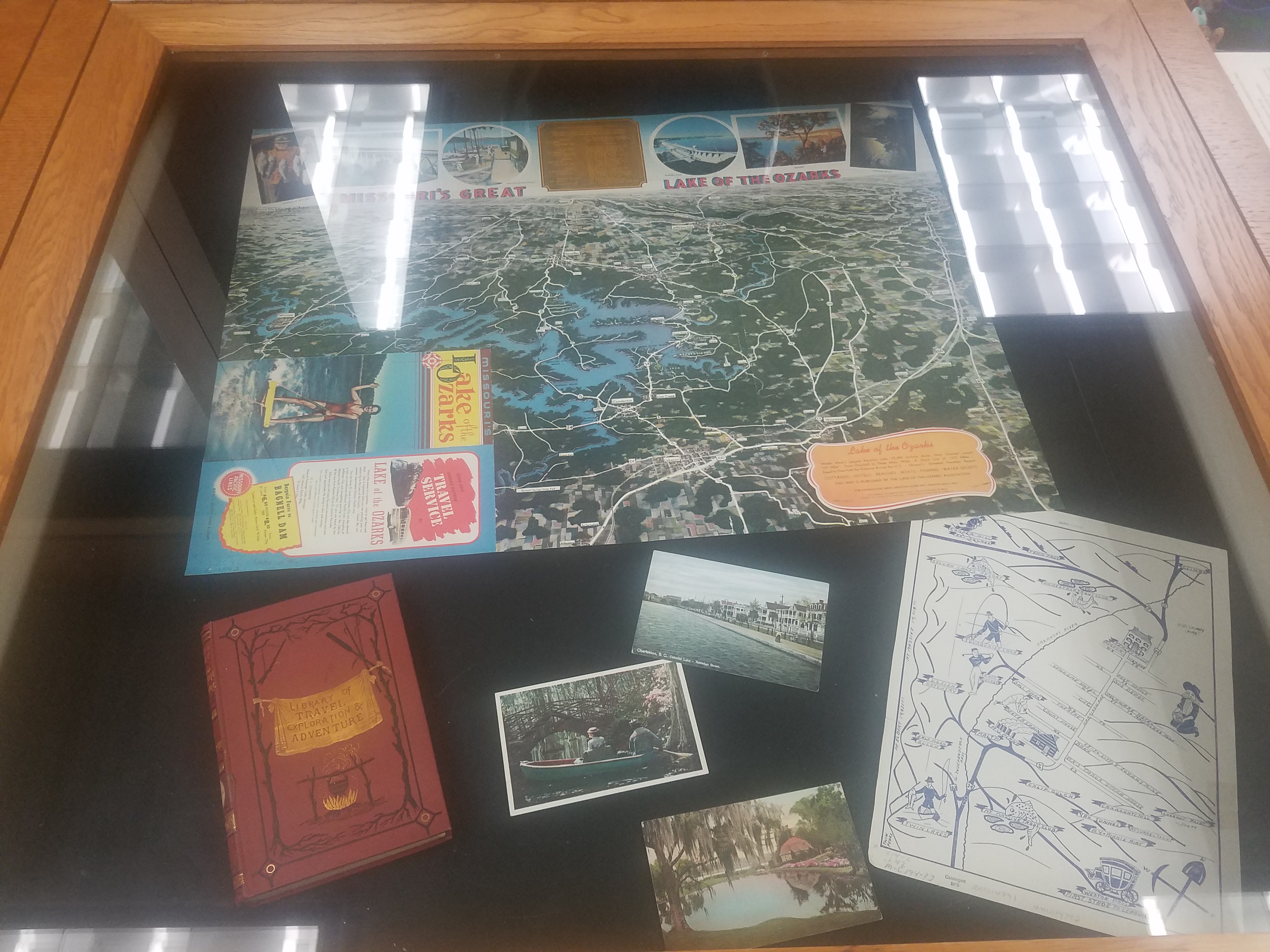
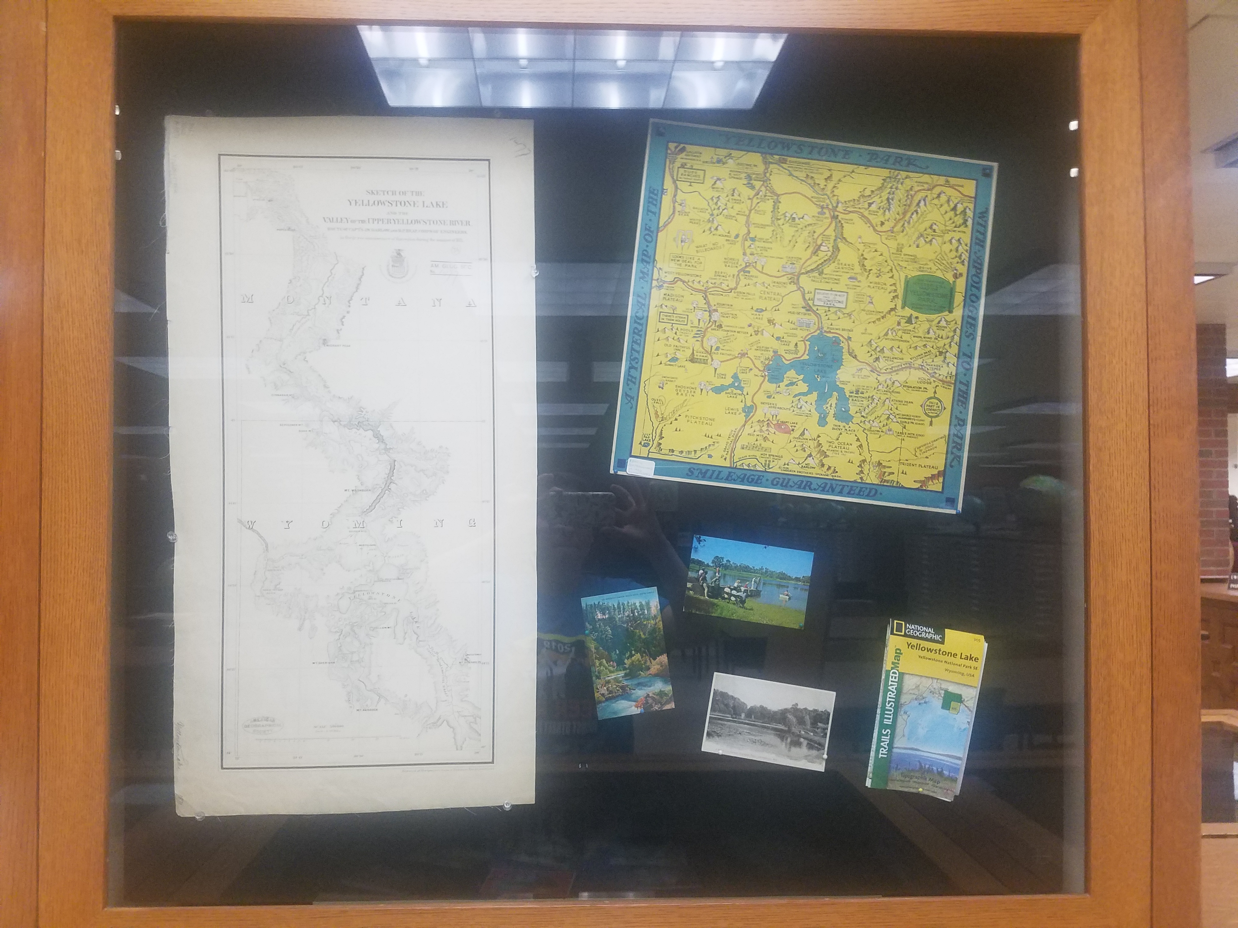
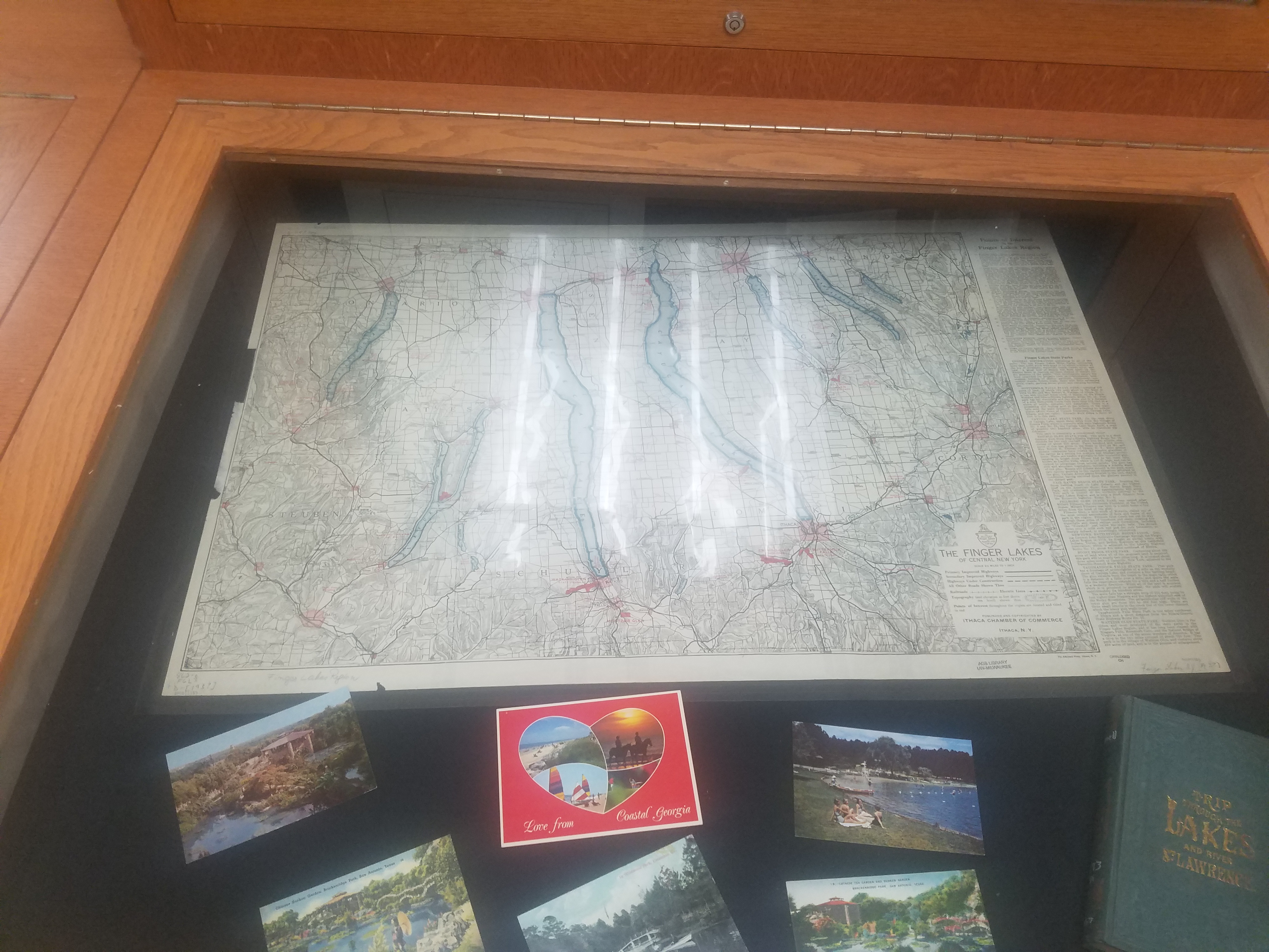
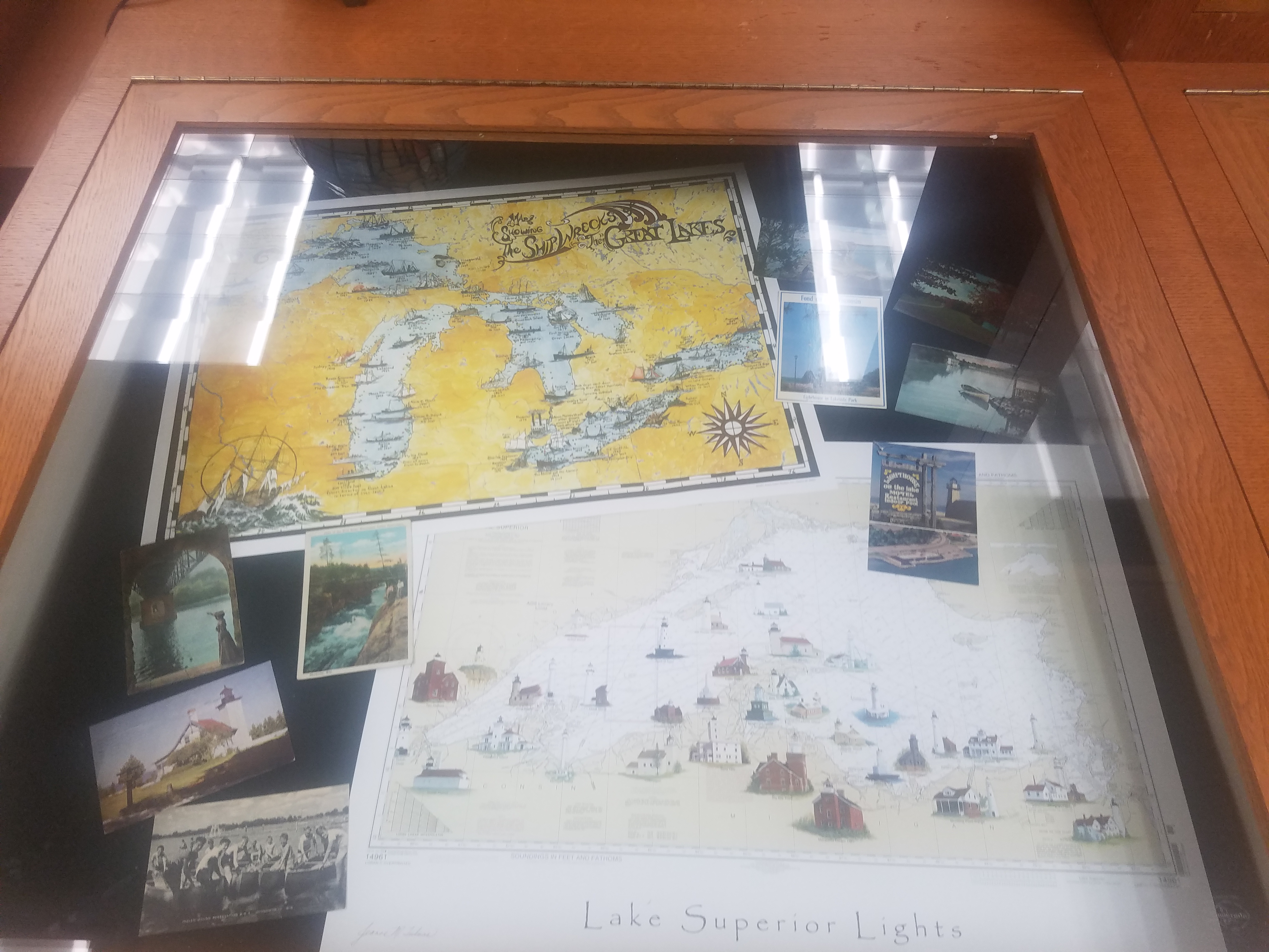
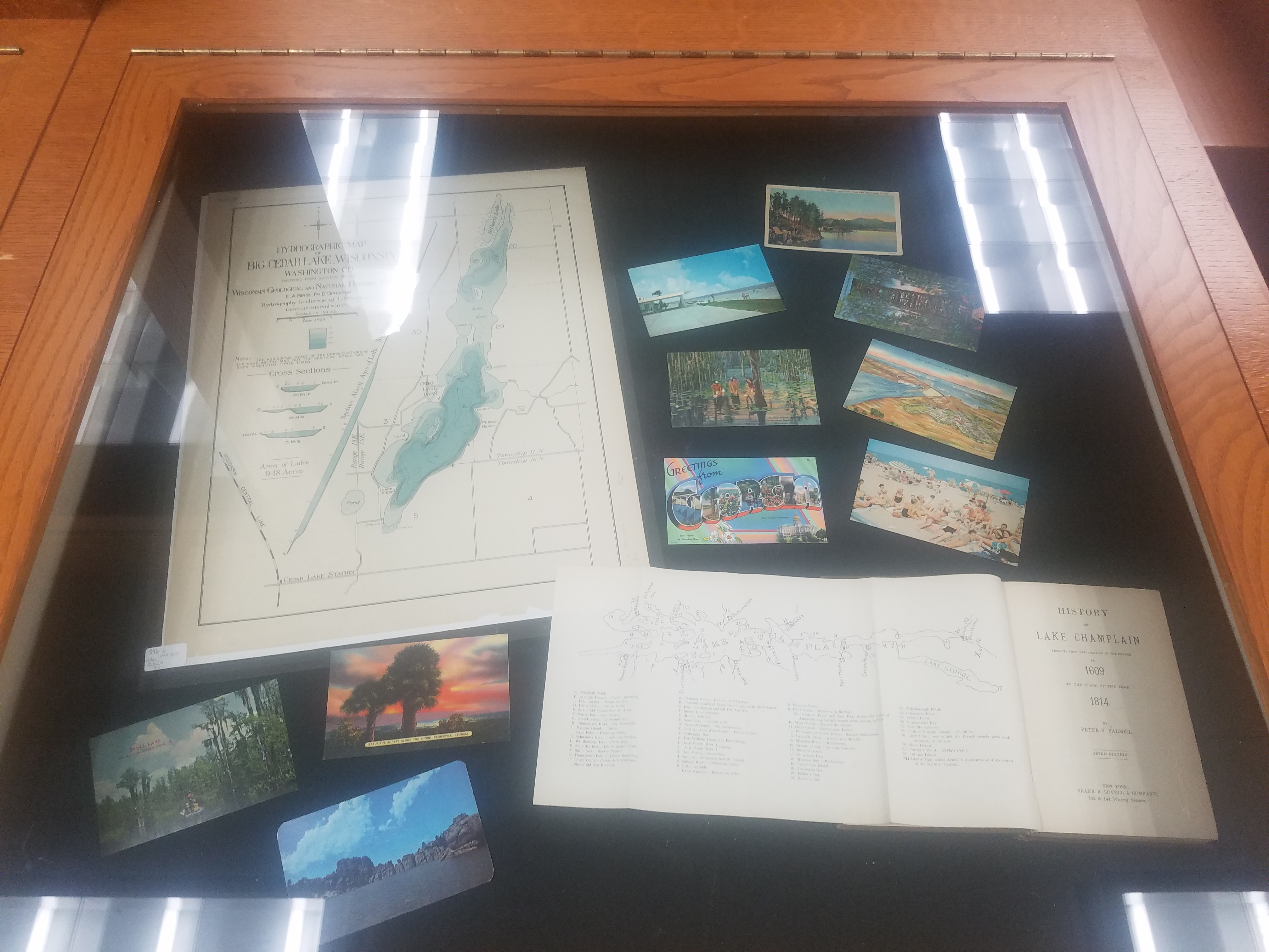
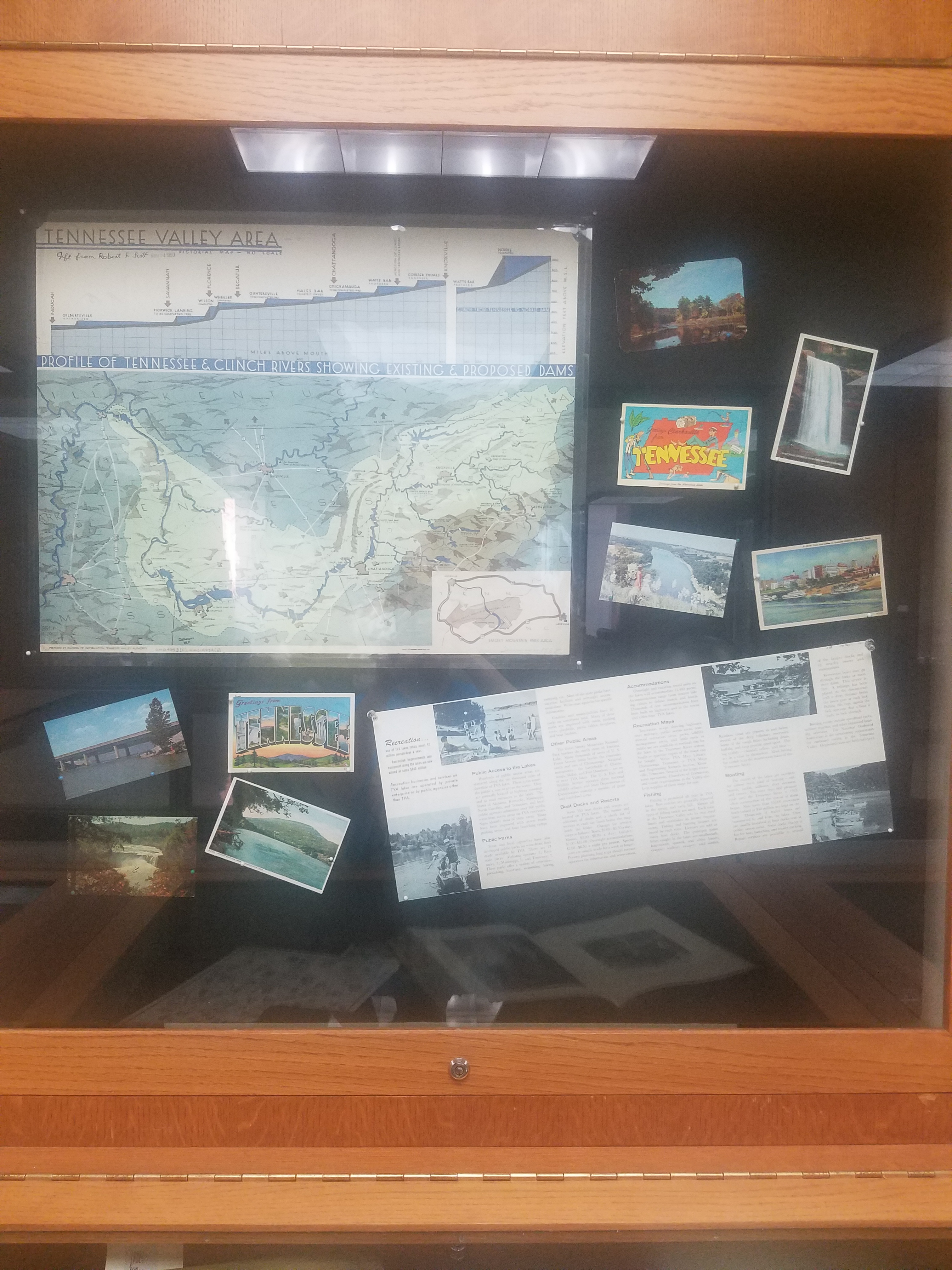
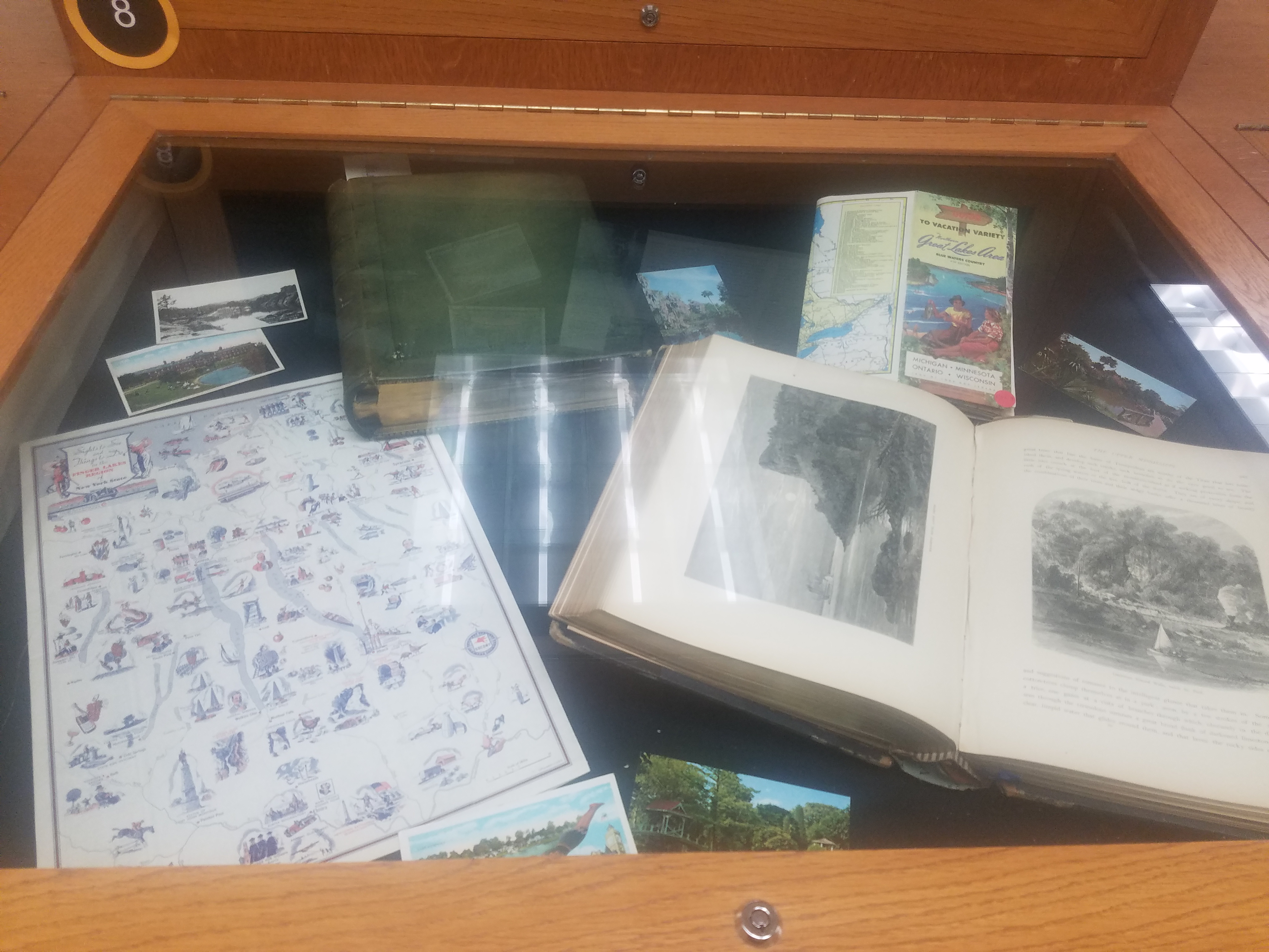
This exhibit is available and open to the public now! We encourage you to come see it in person– and enjoy the rest of the AGSL’s collections while you’re here! The AGSL is open Monday-Friday, 8:00-4:30. Please come and see us!
Imperial Russian Nautical Charts of the Black Sea Atlas at the AGSL Part I
By Josephine Miller
The Crimean War: Loss of the Black Sea Fleet and Reform
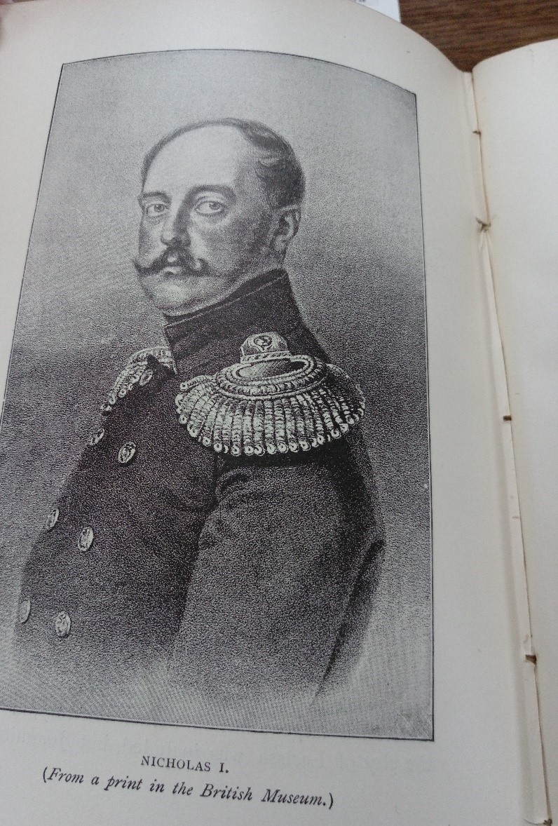
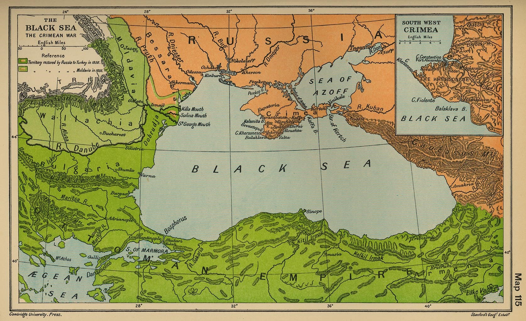
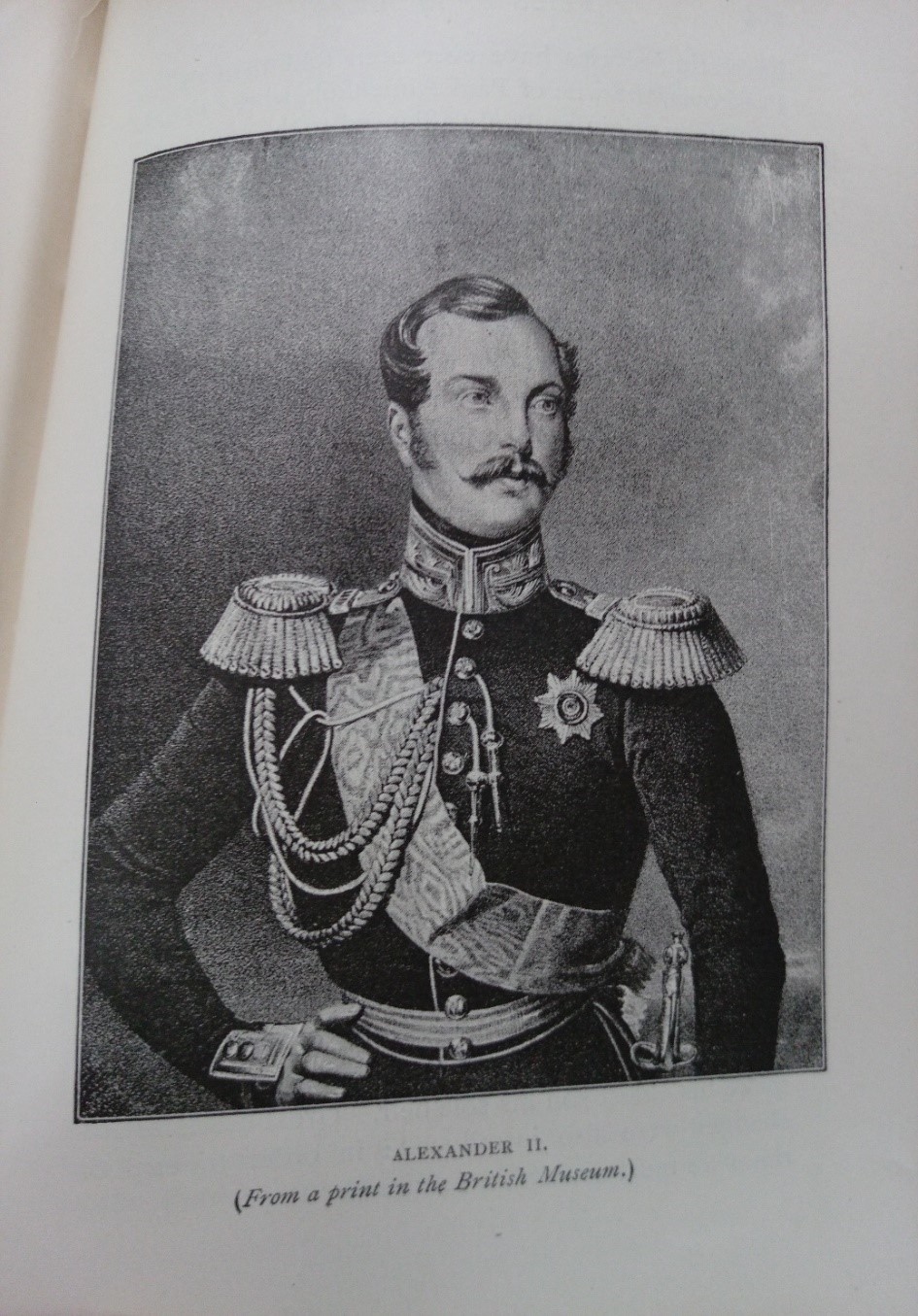
Tsar Alexander II (1818-1881) ascended to the throne on February 19 1855. He succeeded his father Tsar Nicholas I, who died at the age of 58 while Russia was losing the Crimean War (1853-1856). The war was fought between the Russian Empire and the alliance of the Ottoman Empire, Great Britain, France, and Sardinia. Alexander II came to the throne at the age of 36 at the end of the war. In the beginning of his reign, the young tsar was forced to face to the defeat of the Russian Empire. The Treaty of Paris was signed on March 30 1856, officially ending the Crimean War.
In the treaty, Russia ceded the mouth of the Danube and some of Bessarabia to the Ottomans. Additionally, Russia accepted the neutralization of the Black Sea. Neutralization meant not maintaining a navy or coastal fortifications in the Black Sea. In addition, Russia withdrew from the Danube Principalities of Moldavia and Wallachia and accepted an international commission to oversee navigation of the Danube. Russia also forfeited its claim as protectorate of Orthodox Christians in the Holy Land and in the Ottoman Empire. The Crimean War was a great defeat for the Russian Empire, so much so that one rumor circulated that Nicholas I had poisoned himself. The war signified the decline of Russia’s influence in Southeastern Europe and the Near East. [1] As Russia was losing the war and Nicholas I approached death, he requested his funeral to be modest and the period of mourning to be as brief as possible. [2]
The defeat of Crimea was pivotal moment for Russian history. Notably, the Black Sea has historically been of great political importance for Russia, given its warm water ports. The defeat made a deep impression on the young Tsar Alexander II. He began his reign having to deal with the consequences of his father’s reign. Nicholas I had been a conservative autocrat who believed it was his sacred duty to uphold tradition. Under Nicolas I, Russia remained frozen in time. His rule is regarded as a conservative reaction to the Enlightenment. This reaction or rejection is best explained by his doctrine on Official Nationality (Теория официальной народности), which was based on the Triad “orthodoxy, autocracy, and nationalism” (Православие, самодержавие, народность).
The conservative disposition of Nicholas I is seen as the primary reason for the defeat in Crimea by the reformers. Before the war, Russia and its military enjoyed the positive reputation it had earned in its victory over Napoleon. However, while Nicholas I focused on upholding the tradition of the Triad, the West advanced scientifically and militarily. Consequently, when the war broke out, Russia faced the more advanced and modern armies of the West. The war revealed how lacking and inefficient the Russian military was in comparison to the West. The inefficient bureaucracy of the military, the lack of modern technology, and corruption were all examples of the inadequacies of the military. The outdated Russian military was frozen in the Napoleonic era, while the Allies had advanced into the Victorian era.
The industrialization in the West created a technological gap between Russia and the West, in particular, Russia and Great Britain. Great Britain was Russia’s primary imperial rival at the time. Technologically, the world had changed quickly in the middle of the 19th century. The period saw new technological innovations such as railroads, telegraphs, improved steam engines, and improvements in steel and iron. Significantly, Great Britain had the capability to import food and raw materials from around the world, allowing the mass production of consumer goods. Furthermore, the expanding of education in Western society accommodated this industrialization; Russia, on the other hand, lagged behind in all of these areas.
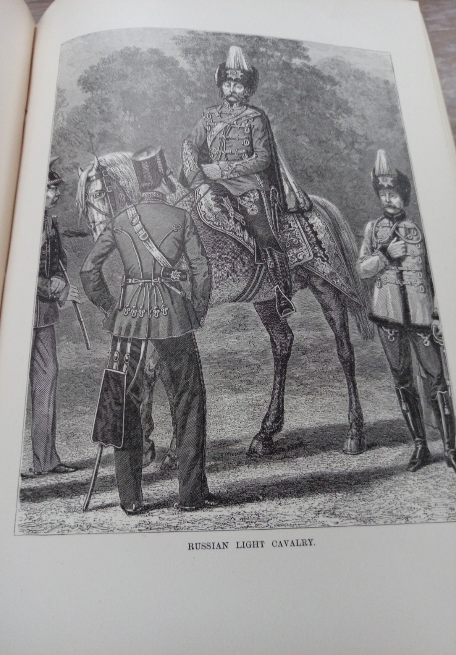
Lagging behind proved to be Russia’s disadvantage in the war. The fighting in the Crimean War revealed these disadvantages in the Russian military. Russia’s fleet of sailing ships could not fight against the steamships of Britain and France. Moreover, the Russian military relied on serfs for soldiers. Serfs could not provide the needed gunpowder and shells for battle. Ultimately, Russian soldiers marched into battle with smoothbore muskets, only to face the long-range artillery fire of the allies. [3]
In the aftermath of Crimea, reform found supporters from both the Slavophiles and the pro-Western factions. Both had been greatly upset by the defeat. The Slavophiles saw war against the Ottomans as a crusade for Orthodox Christianity and for Constantinople. Whereas, the Westernizers were dismayed by Russia losing its preeminent status as a European power that it had earned after the Napoleonic wars.
Alexander II began his reign as a proponent of reform, both militarily and politically. His most famous reform was the abolishment of serfdom, earning him the title the Tsar-Liberator or Alexander the Liberator. Alexander II was not the first tsar that wanted to end serfdom, but the Crimean War provided the opportunity. The serf army proved to be ineffective. If Russia were to modernize it would need to industrialize, which would also include a citizen army. The institution of serfdom inhibited both modernization and industrialization. Serfdom kept the Russian economy agrarian and stifled the innovation needed for industrialism. In the following decade, Alexander II enacted political and military reforms in order to modernize Russia and its military.
Revival of the Black Sea Fleet
Nonetheless, the treaty of Paris limited naval ambition due to the demilitarization stipulation in the treaty. Opportunity would arise in 1870s for the Black Sea Fleet. On September 1, 1870, Emperor Napoleon III surrendered to Prussia. During the Franco-Prussian War, Russian remained officially neutral. However, according to the memoirs of Count Dmitry Milyutin, Field Marshall and Minister of War Alexander II sent St. George Crosses to Prussian officers and a congratulatory telegram to King Wilhelm I after Prussian victory. Notably, Wilhelm I was the maternal uncle of Alexander II. Additionally, Russian officers served in the Prussian army. [4]
The Franco-Prussian War led to the establishment of the German Empire. Upon unification, King Wilhelm I of Prussia became German Emperor. Otto von Bismarck, Chancellor of the new German Empire, wanted to gain favor with Russia due to the mutual threat of Polish nationalism. Bismarck sent Count Constantin von Alvensleben to Russia in order to come to an agreement on cooperation against Polish rebellion. [5]
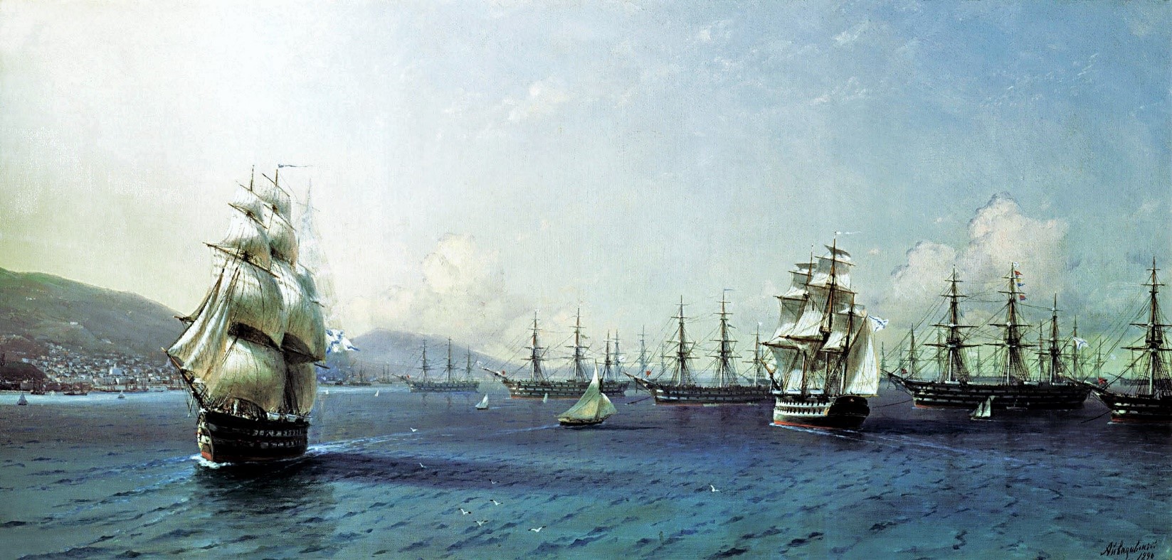
Black Sea Fleet in the Bay of Theodosia, just before the Crimean War, 1890, Ivan Aivazovsky,
Feodosiya National Gallery I. K. Aivazovsky
German rapprochement aided Russia in a more important foreign policy objective for Russia: the Black Sea. In 1870, Prince Alexander Gorchakov, Foreign Minister, used France’s defeat to denounce the Black Sea clause of the Treaty of Paris (1856). Gorchakov’s denouncement included the refusal to uphold the clause. In his justification, Gorchakov cited to Turkey violations of the treaty and he argued that the conditions of warfare have become more dangerous since 1856 due to the more destructive armaments. Bismarck supported Gorchakov on the Black Sea clause. Though Britain protested, the European powers agreed to it through the Treaty of London in 1871, which abrogated the Black Sea clause of the Treaty of Paris. This allowed Russia to rebuild the Black Sea Fleet and military fortifications on the Black Sea. [6]
Egor Pavlovich Manganari (Егор Павлович Манганари)
The Atlas of the Black Sea (Атлас Чёрного Моря) was published between 1841 and1842. The surveying for the atlas was led by Captain-Lieutenant Egor Manganari (1796-1868). He was the eldest son of Panayot Manganari, (also known as Pavel Manganari in Russian). Panayot Manganari was a Greek nobleman and immigrant to the Russian Empire from the Greek island Chios. He immigrated to Russia due to conflict with the Ottomans, taking advantage of the Catherine the Great’s invitation to settle Greeks in the Southern Russian Empire. He married Alexandra Timofeevna and they had six children: three daughters, Maria, Ekaterina, and Anastasia, and three sons who served as officers in the Black Sea Fleet, Egor, Ivan, and Mikhail. The family first lived in Yevpatoriya and later in Nikolayev. [7]
Egor Manganari served in the Black Sea Fleet of the Imperial Russian Navy as a naval officer and hydrographer. He attended the Black Sea Navigational School in Nikolayev. There he studied Russian, English, classical subjects, and subjects related to geography such as mathematics, geodesy, navigation, and cartography.[8]
In 1813, he entered the Black Sea Fleet as a Navigation Assistant. By 1816, he received the rank of First Officer Midshipman and was later promoted to Lieutenant in 1821. He was appointed commander of the rig Nikolai (Николай) where he produced an inventory the Dnieper Estuary and the Bug River. His work was highly praised, earning him the Order of Saint Anna, 3rd Class, and the commission to survey the Azov and Black Sea. He commanded the Nikolai until 1827, when he received the command of the yacht Golubka (Голубка). The expedition of the Black Sea was launched in 1826 and continued for ten years. Manganari still participated in the Russo-Turkish War (1828–29), for which he was awarded the Order of Saint Vladimir, 4th Class. In 1833-1834, during the Caucasian War, he also did hydrographic surveys of the Caucasus, for which he was awarded the Order of Saint Stanislav, 2nd class. [9]
By 1838, he had been promoted to lieutenant-colonel and completed his survey of the Black Sea and Azov Sea. His nautical charts were supported by the Admiral Mikhail Lazarev, Commander of the Black Sea Fleet. After the Black Sea expedition concluded, he was granted permission by the Navy to publish them. The nautical charts were brought to Saint Petersburg to be engraved and published as an atlas. After the publication of the atlas, Manganari was awarded the Order of Saint George, 4th class. Manganari continued to do hydrographic surveying of the Black Sea after the publication of the atlas. In 1849, he received the rank of major-general and was appointed as the director of the Lighthouses of the Black Sea and Azov Sea. Manganari remained at that post until he retired in 1856. [10] [11]
[1] Nicholas V. Riasanovsky and Mark D. Steinberg, A History of Russia, (New York: Oxford University Press, 2011), 333-336.
[2] Kaputina, Tatiana Aleksandrovna. “Nicholas I.” In The Emperors and Empresses of Russia: Rediscovering the Romanovs, (Armonk, New York: M. E. Sharpe), 292.
[3] Russia in the Nineteenth Century: Autocracy, Reforms, and Social Change, 1814-1914, (Armonk, New York: M.E. Sharpe) 85.
[4] Ibid. 161.
[5] Nicholas V. Riasanovsky and Mark D. Steinberg, A History of Russia, (New York: Oxford University Press, 2011), 380.
[6] Russia in the Nineteenth Century Autocracy, Reforms, and Social Change, 1814-1914, (Armonk, New York: M.E. Sharpe) 161.
[7] Выдающиеся морские гидрографы братья Манганари. Часть I. Николаевский Базар. [Outstanding Marine Hydrograph Brothers. Part I, Nikolayev Bazar].
[8] Ibid.
[9] Ibid.
[10] Ibid.
[11] Üçsu, Kaan. “Cartographies of the ‘Eastern Question’: Some Considerations on Mapping the Sea of Marmara and the Black Sea in the Nineteenth Century.” In Philosophy of Globalization, (Berlin/Boston: De Gruyter, 2018) 259-260.
Franklinia: The Fourteenth State in the Union
By Lauren Maddox
After the American Revolution, North Carolina was in debt. To be fair, the entire country was in debt; it was just that Congress, who was also dealing with their own debts, began to collect. North Carolina didn’t have any capital to pay off their debts to Congress– instead, they voted in April 1784 to give Congress a parcel of land, around 29 thousand acres, between Appalachia and the Mississippi River.
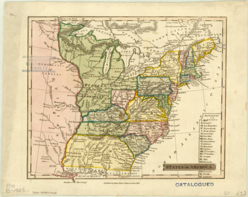
Click the link to see the States of America, 1832. Rare map recording the existence of a territory called “Franklinia” in our Digital Collections
This parcel of land– which is now East Tennessee– was left unprotected while North Carolina waited for Congress to take possession. The territory was ceded on one condition: Congress had to assume ownership of the area within two years. Without protection, the people living there were vulnerable; they weren’t well-situated for easy trade and had displaced, sometimes violently, the indigenous peoples who lived there originally.
Congress was unable to take ownership before North Carolina decided to rescind their offer just four months after their initial vote, so North Carolina made plans to reincorporate the territory– except that the people who lived there didn’t want to be reincorporated. As it turned out, despite being more exposed, being independent from North Carolina was a better deal. They weren’t as heavily taxed, and they weren’t satisfied with the protection North Carolina was providing anyway, so there didn’t seem to be any good reason to go back to being part of North Carolina.
And two men were already seeking to create a new Western state; John Sevier and Arthur Campbell had been discussing the possibility of establishing their proposed state with territory from Virginia, North Carolina, Alabama, and the region that would become Georgia, Kentucky, and Tennessee for years. Campbell’s call for a new state was well-received by other frontiersmen, but Virginia Governor Patrick Henry shot down his initial attempt by passing a law to prevent the use of Virginia territory in the creation of new states. They had made some headway in Kentucky, but the unclaimed territory ceded by North Carolina was a golden opportunity to establish the independent state they had been endeavoring to create for so long.
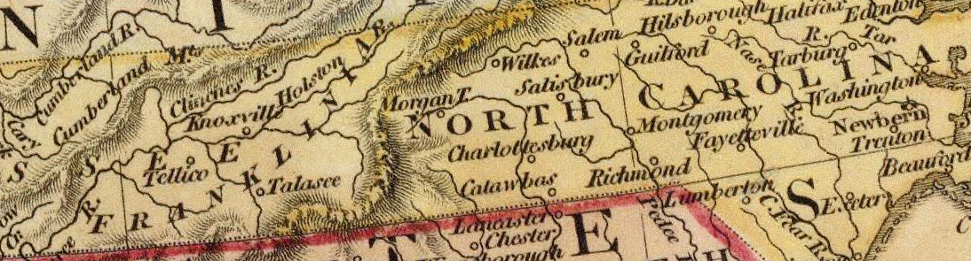
Detail of Franklinia 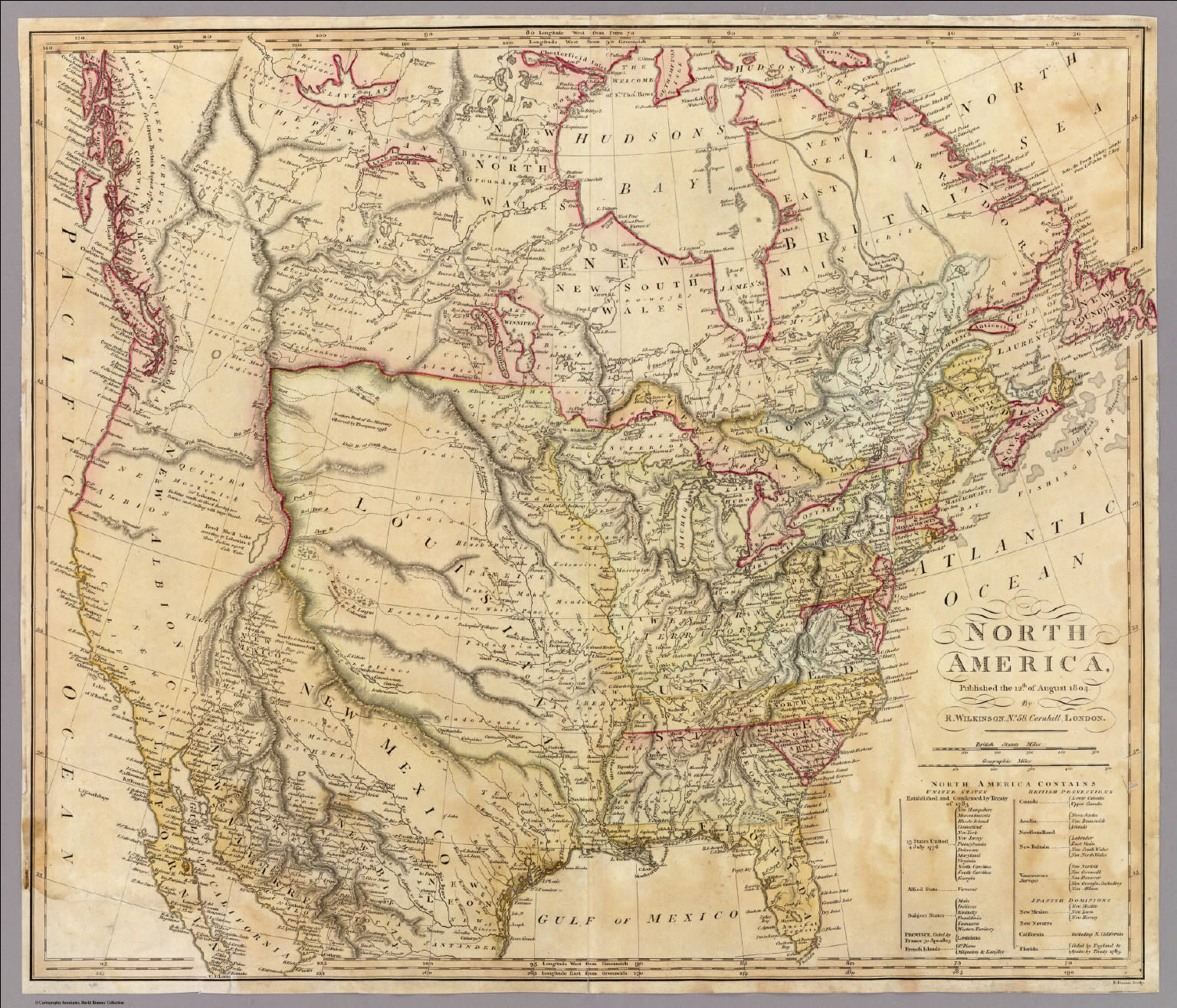
Click the link to see the 1804 Map of North America from the David Rumsey Map Collection
On August 23, 1784, delegates from the unincorporated counties met in Jonesborough to discuss whether or not they would rejoin North Carolina. They voted to become independent. Leaders were quickly elected; John Sevier became governor and a constitutional convention was called in December. The original draft of their constitution forbade doctors, lawyers, and preachers from becoming elected officials, but this was unpopular and this draft was dropped in favor of just using North Carolina’s state constitution.
The following May, just a year after the territory was originally ceded by North Carolina, a delegation petitioned Congress to become the fourteenth state in the union as Frankland. The delegation decided to use the name Franklin as an homage to Benjamin Franklin in the hopes that he might express some support for the new state. Unfortunately, Franklin wrote back that he didn’t know enough about their endeavor to support them, but wished the State of Franklin luck anyway. The final vote to establish Frankland as a state failed with less than the required two-thirds majority.
By December 1785, Franklinia (which had undergone several name changes by this point) was operating as an independent republic. Its issues with North Carolina were never resolved, and so they refused to rejoin their original state. The economy was in shambles; there was no official currency and bartering became the standard exchange. John Sevier himself was paid in deer skins. Citizens were granted a reprieve from taxes while the economy stabilized. A new capital was chosen because Jonesborough was so close to the North Carolina seat of government, and a new constitution drafted.
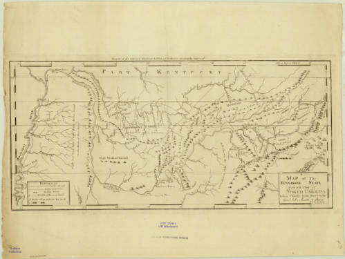
Click the link to see the Map of Tennessee “Formerly Part of North Carolina” 1796 in our Digital Collections
In 1786, North Carolina made Franklinia a new offer: if they rejoined North Carolina, they wouldn’t have to pay any back-taxes. Franklinian delegates refused this offer, which was the beginning of the end. Several key supporters of the movement withdrew and North Carolina began to militarily reunite Franklinia with its state government. Using armed force, North Carolina re-established government facilities alongside the Franklinian courts and jails. Franklinia’s decline took place over several years. In 1787, Franklin began forcibly seizing Native American territory, angering their neighbors. In 1788, three men were killed in a skirmish over John Sevier’s property; the conflict lasted ten minutes before Sevier’s handful of troops were forced to withdraw. Trying to protect Franklinia from the Chickamauga and Chickasaw tribes he had angered in his landgrab, Sevier began negotiating with Spain. North Carolina, resistant to Spanish interference, arrested Sevier. In 1789, the last few loyal Franklinians swore allegiance to North Carolina again. The government of Franklinia was officially and completely dissolved in 1791. Maps of Franklinia are rare because of how short-lived the de facto republic actually was; the AGSL has a single map featuring the state– it is not noted on other maps of the area from this time.
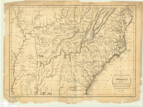
Click the link to see the Map of the Southern States of America in 1795, including territory labelled “Tennessee Government” in our Digital Collections
But after everything it took to reunite the State of Franklin and North Carolina, North Carolina ceded the territory again in 1790 to form the Southwest Territory. This territory would become Tennessee– and John Sevier was its first governor.
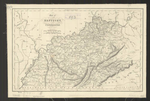
Click the link to see the 1832 Map of Kentucky and Tennessee in our Digital Collections
- ← Previous
- 1
- 2
- 3
- Next →
