Angie’s Blog
Christchurch earthquake, 10 years ago
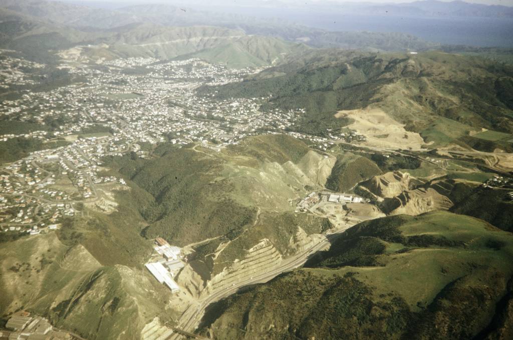
On 22 February 2011, a fatal earthquake hit Christchurch, New Zealand. One-hundred and eighty-five people were killed and the city’s CBD was destroyed. The 6.3 magnitude earthquake hit during the lunch hour and its epicenter was just 6km south of the city. Christchurch’s central city and eastern suburbs were badly affected, with damage to buildings and infrastructure already weakened by the magnitude 7.1 that had occurred less than a year earlier.
https://collections.lib.uwm.edu/digital/collection/agsoceania/id/690/rec/13
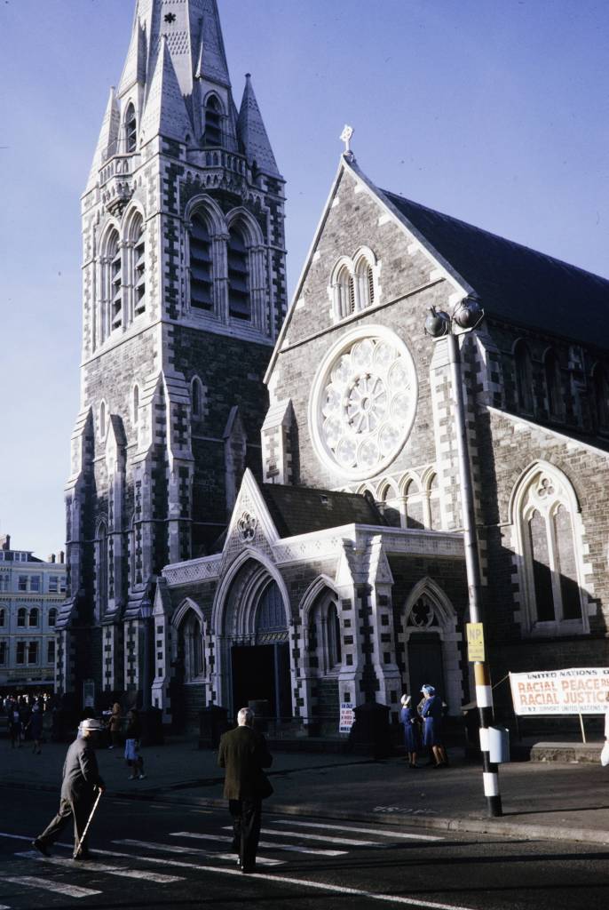
“Two story buildings in the CBD were flattened and masonry in older parts of the city crumbled onto the streets. The steeple and bell tower of Christ Church Cathedral collapsed into the square, and its whole front face and beautiful rose window – the spiritual and symbolic face of Christchurch itself – teetered, and would later collapse onto the entrance portico, opening the nave to wind and weather, and the pigeons of Cathedral Square. [Australian Geographic].”
The earthquake destroyed the Christchurch Cathedral’s spire and severely damaged the structure as a whole. The Anglican Church voted to demolish the building but various groups came together to save the building.
https://collections.lib.uwm.edu/digital/collection/agsoceania/id/825/rec/1
https://collections.lib.uwm.edu/digital/collection/agsoceania/id/708/rec/32
Demolished in 2013.
.
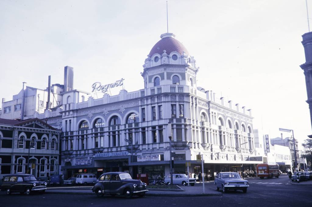
https://collections.lib.uwm.edu/digital/collection/agsoceania/id/796/rec/4 The Regent Theater opened on 16 August 1930 and had a seating capacity of 1,568. It survived a 1976 fire and major renovations in the 1980s and 1990s but succumbed to the earthquake and was demolished in July 2011.
About 10,000 houses were demolished in the suburbs. The earthquake caused soil liquefaction and rockslides in and around Christchurch, leaving many areas infeasible for rebuilding. Efforts continue in Australia to earthquake proof buildings.
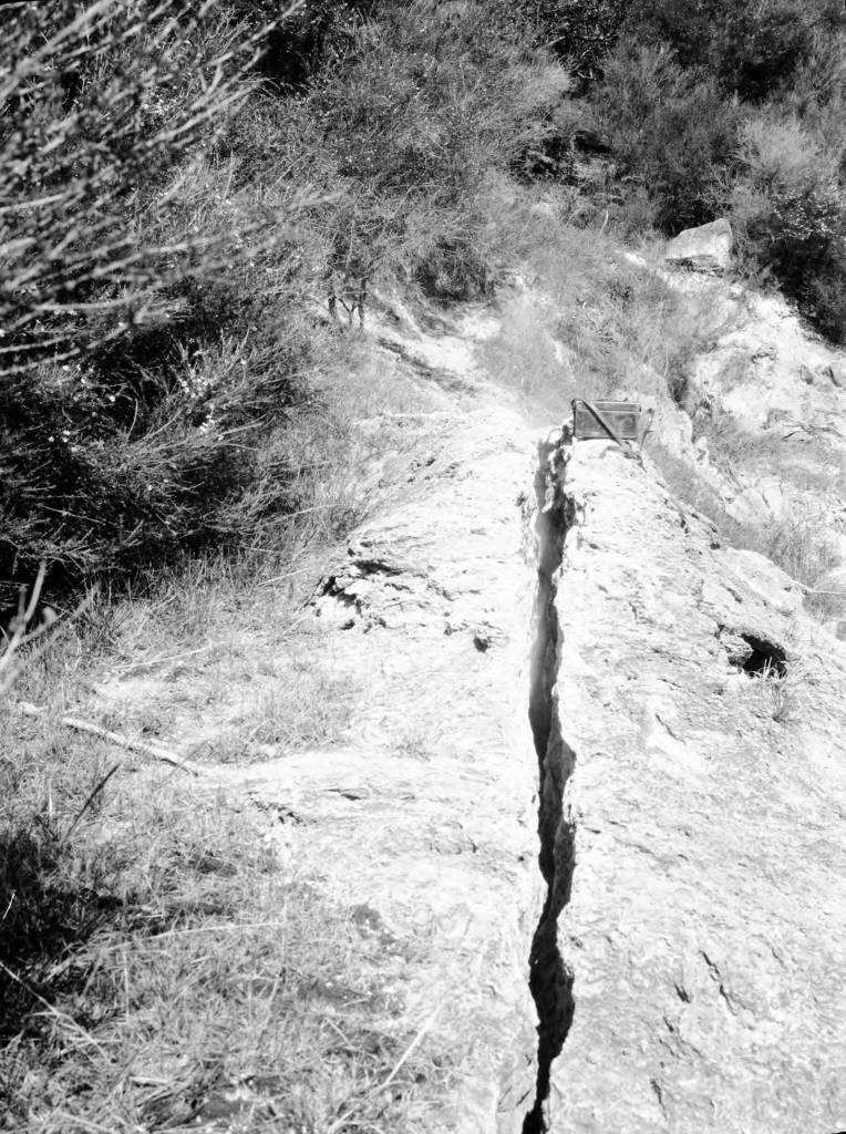
Earthquake crack 5 feet deep, 6 inches wide and 40 feet long with emerging hot spring (the crack trends South 30 degrees East) Te Puia Springs. New Zealand. (1925) from the AGSL Photocraph Collections https://collections.lib.uwm.edu/digital/collection/agsoceania/id/232/rec/1
.
Milwaukee Streets named after Black Wisconsinites Joshua Glover and Sherman Booth
by Angie Cope
Joshua Glover escaped enslavement from Benammi Stone Garland’s Missouri farm in 1852 and traveled by foot to Racine, Wisconsin. Because of The Fugitive Slave Act, Garland was legally able to hunt down Glover and recapture him in March 1854. Garland and his men took Glover to a jail in Milwaukee with the plan of returning Glover to Missouri.
However, the morning after Glover’s jailing, it is said that abolitionist Sherman Booth and a mob stormed the jail. Glover was freed but then spent 40 years on the run, finding safe spots along the Underground Railroad system. After decades of running, Glover found ultimate freedom in Canada, where he died.
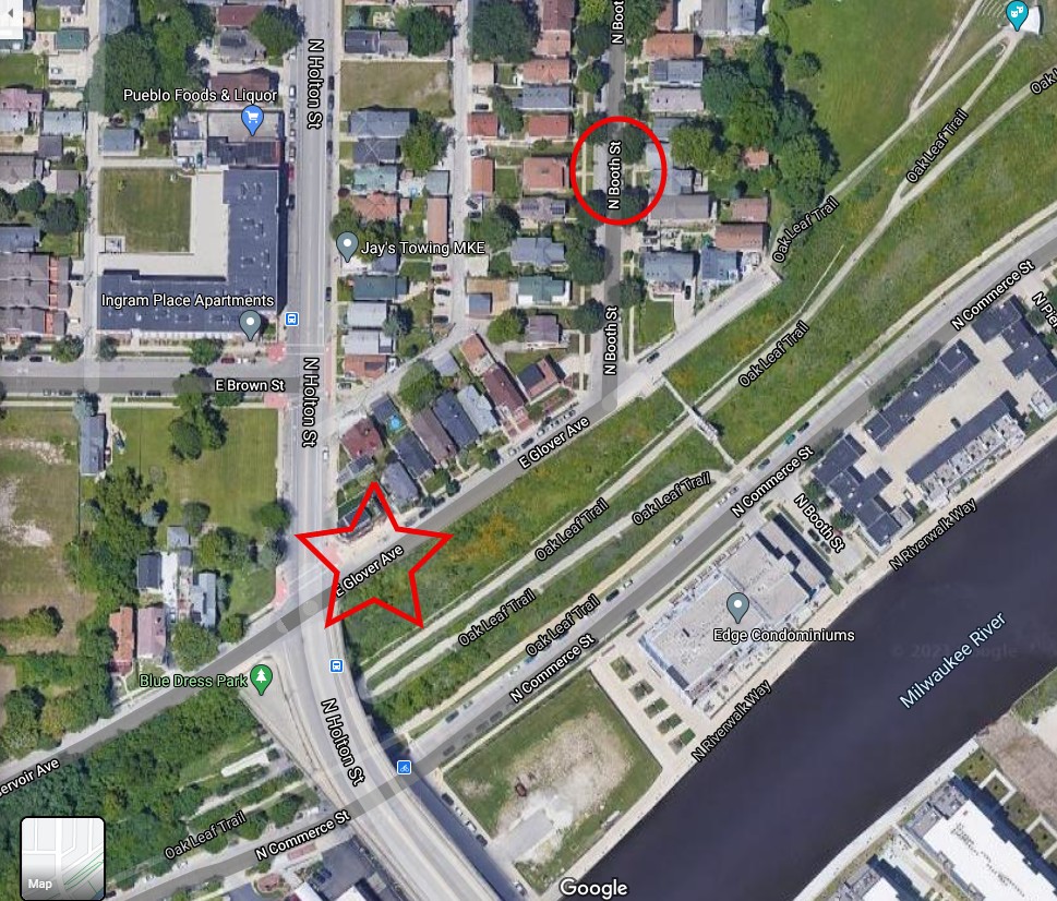
In 1857, Booth Street in Milwaukee’s Riverwest neighborhood was named after Sherman Booth.
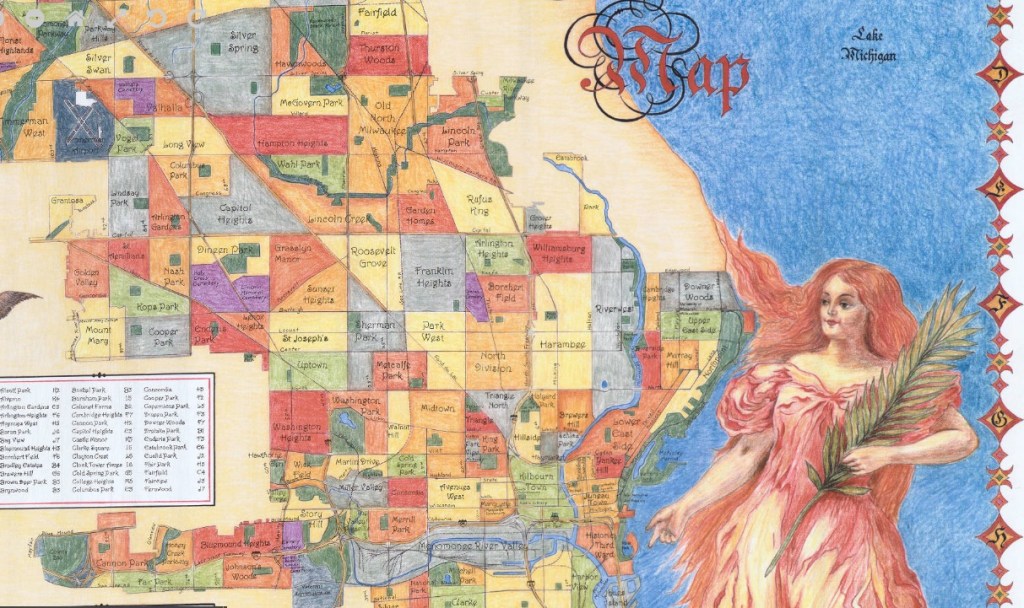
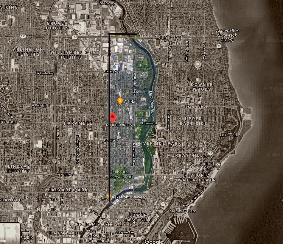
In 2016, some homeowners in the area signed a petition approving the renaming of part of Reservoir Avenue to Glover Avenue. Now there is a cross where Booth Street and Glover Avenue intersect.
View the maps in more detail
Milwaukee neighborhood map / V. Robie and Big Stick, Inc. 2002
https://collections.lib.uwm.edu/digital/collection/agdm/id/11909/rec/2
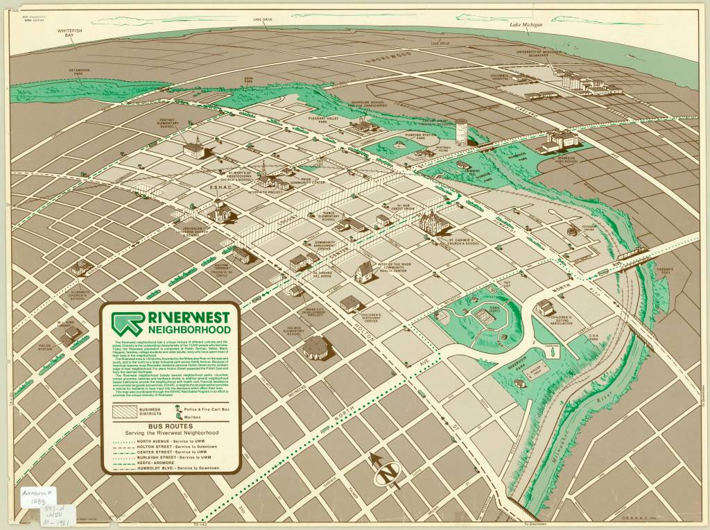
Riverwest neighborhood / Dru Maki, artist 1981
https://collections.lib.uwm.edu/digital/collection/agdm/id/5918/rec/6
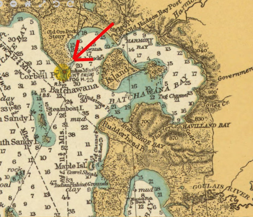
Corbeil Point Lighthouse, Batchawana Bay, Ontario
by Angie Cope
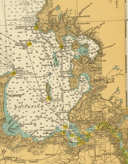
Batchawana Bay is located on the eastern shore of Lake Superior, roughly fifty kilometres north of Sault Ste. Marie.
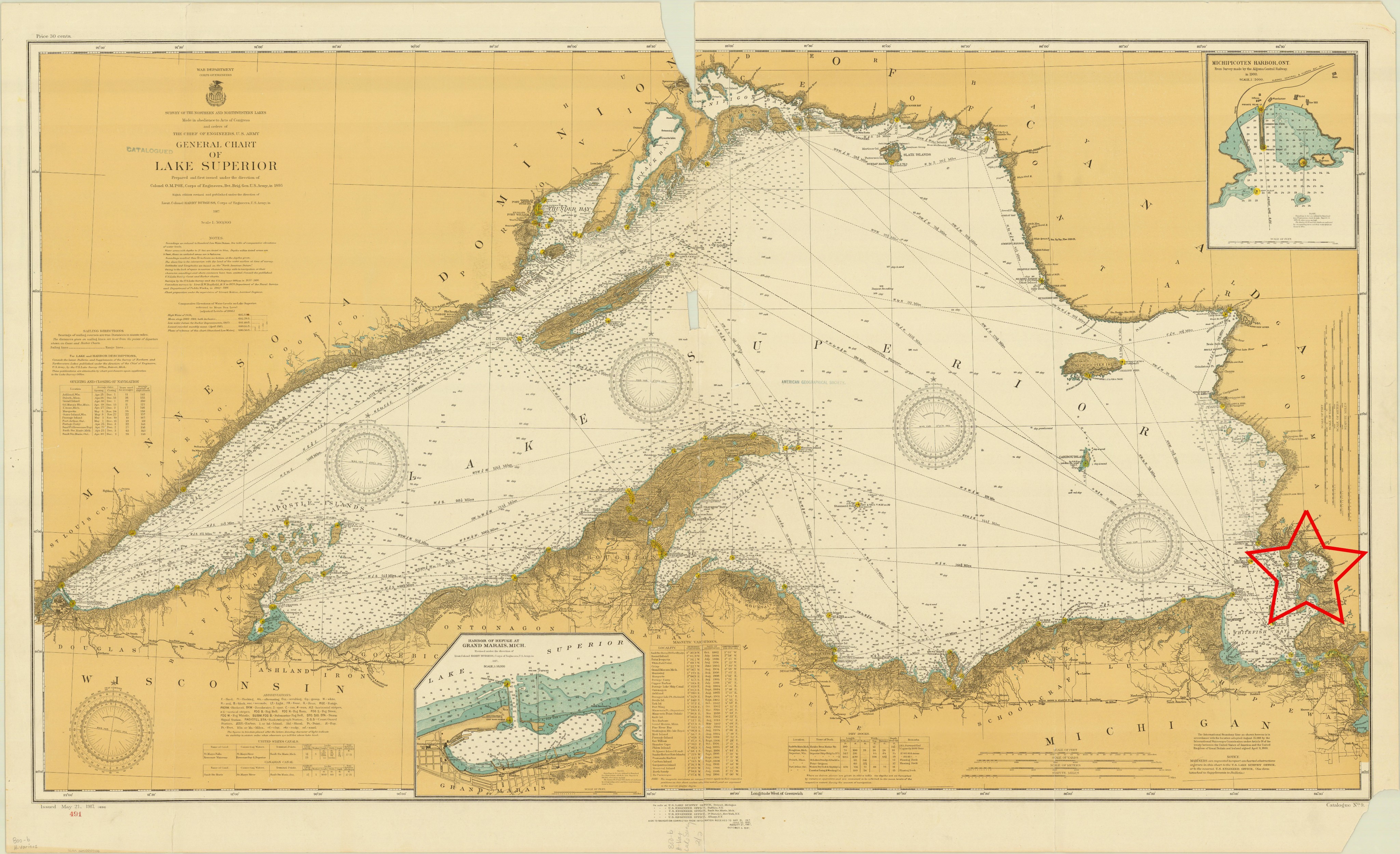
The name is derived from the Ojibwe “Badjiwanung” meaning “water that bubbles up,” describing the turbulent waters in the narrow passage between Sand Point and Batchawana Island. Batchawana Bay was an important fishing place for the Ojibwe and later for the Hudson’s Bay Company, which maintained an outpost and fishing station where Batchawana River enters the bay.
1868 map of Lake Superior
https://collections.lib.uwm.edu/digital/collection/agdm/id/1888/rec/35
The lighthouse was constructed in 1873 of wood and was frequently struck by lightning . In June 1931 a lightening strike burned the original lighthouse to the ground. The photo pictured here is dated 1932 and likely reflects the newly built lighthouse following that fire.
Photograph by Robert S. Platt
The lighthouse had keepers until 1955 when the the hand operated fog-horn was discontinued and lights became automated. The lighthouse was completely discontinued in 1962. Lighthouse keepers included the following men and their families: David Crawford (1873 – 1883), Andrew Crawford (1883 – 1890), Joseph Davieau (1890 – 1914), James Davieaux (1914 – 1915), William Reil (1915 – 1946), Henry D. Nolan (1946 – 1953), Franny Nolan (1953), Robert Collins (1953 – 1955).
Sources:
Information regarding the lighthouse was obtained from The Lighthouse Friends website: https://www.lighthousefriends.com/light.asp?ID=1552
Images used are from the American Geographical Society Library digital photograph and map collections
Economic map of Cambodia, 1964
Royaume du Cambodge, carte economique = Kingdom of Cambodia economical map / Cambodia. Forces armées nationales khmères. Service géographique, 1964.
1 map : color ; 96 x 117 cm
Call number: Maps 445 E-1964
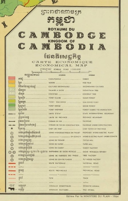
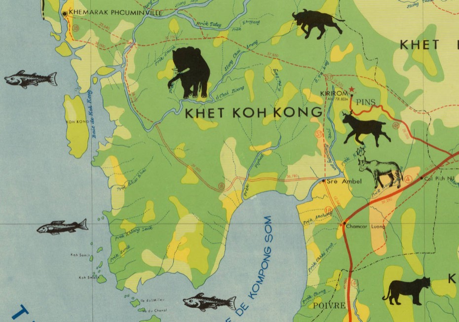
https://collections.lib.uwm.edu/digital/collection/agdm/id/3306/rec/1
First flight blazes the trail for future discovery – The Wright Brothers and Lincoln Ellsworth
by Angie Cope
| On the morning of December 17, 1903, Wilbur and Orville Wright took turns piloting and monitoring their flying machine in Kill Devil Hills, North Carolina. Orville piloted the first flight that lasted just 12 seconds and 120 feet. On the fourth and final flight of the day, Wilbur traveled 852 feet, remaining airborne for 59 seconds. That morning, the brothers became the first people to demonstrate sustained flight of a heavier-than-air machine under the complete control of the pilot. |
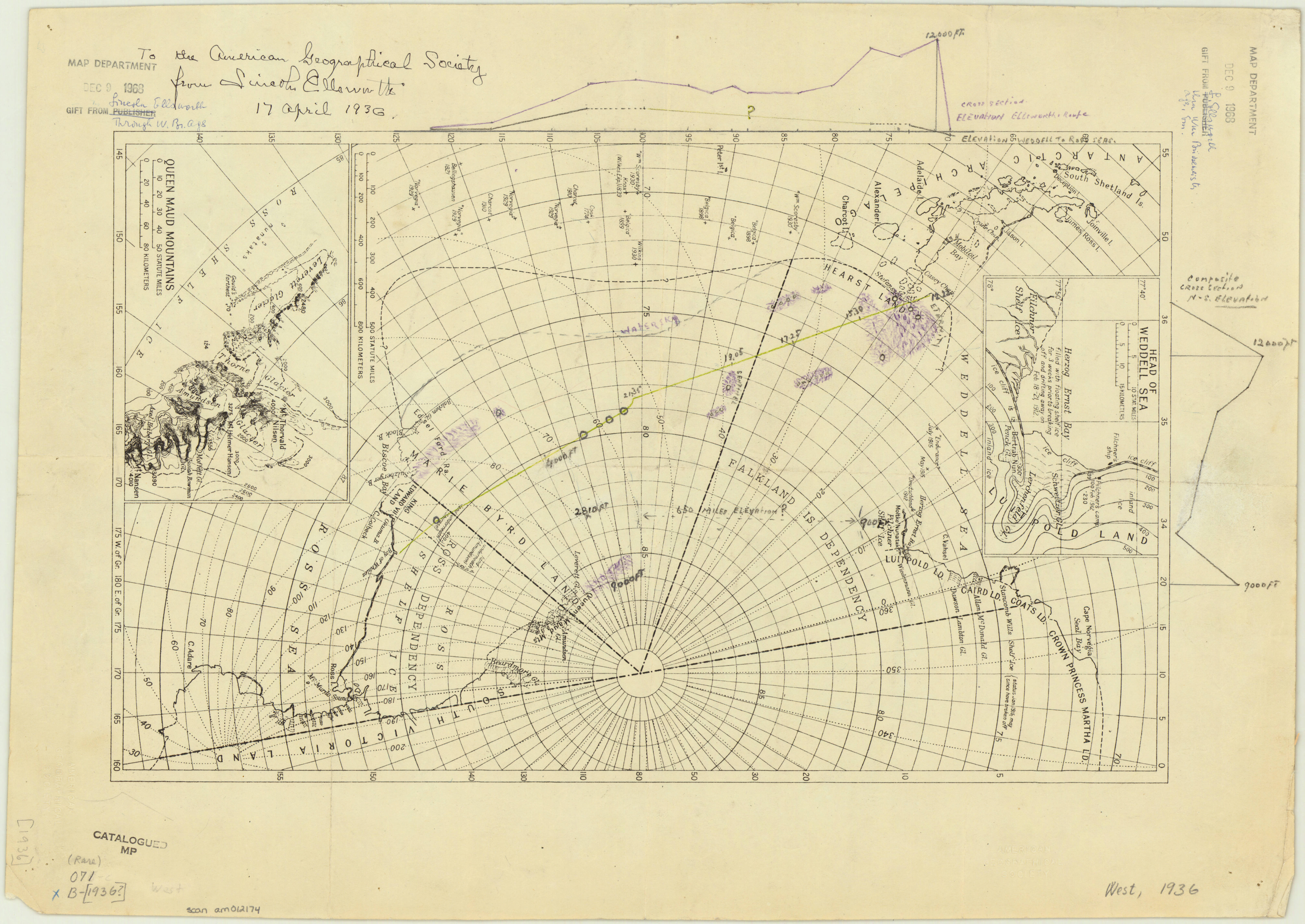
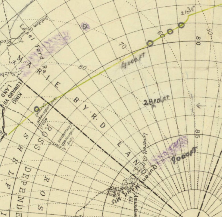
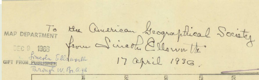
Orville and Wilbur Wright are credited with inventing, building, and flying the world’s first successful motor-operated airplane. Their inventions led the way for world exploration using airplanes. One notable flight was the Ellsworth Transantarctic Flight Expedition. Lincoln Ellsworth with pilot Herbert Hollick-Kenyon completed the first transantarctic flight in history. With four stops along the route, the flight covered 2200 miles with an elapsed time of approximately 20 hours.
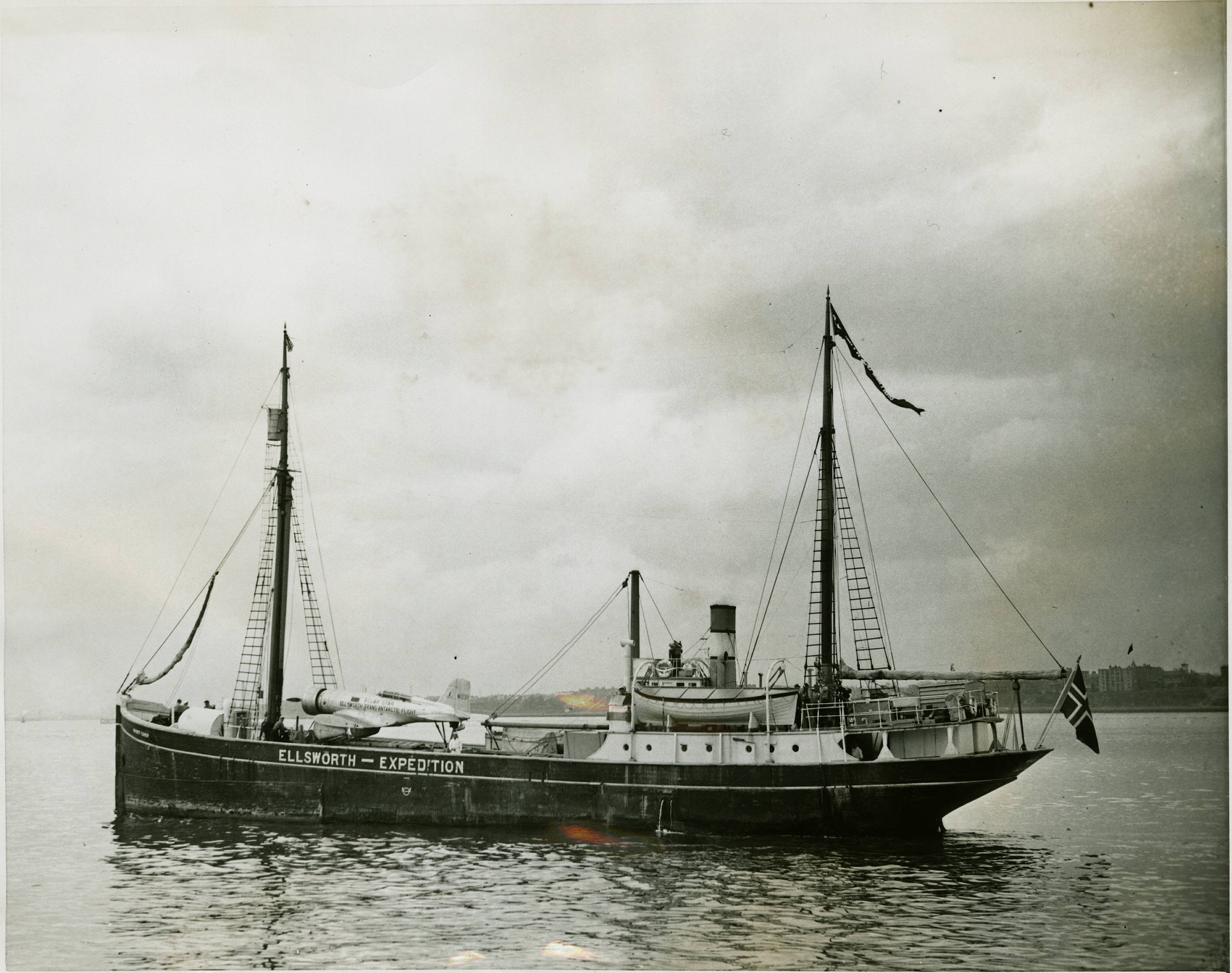
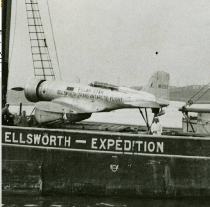
The transantarctic flight was the longest flight in Antarctic history, an accomplishment not repeated again until January 1956.
The story map of flying being a chronicle of man’s conquest of the air / designed, pictured and published by Ernest Dudley Chase of Winchester Massachusetts, 1942
1 map : color ; 65 x 47 cm, on sheet 77 x 56 cm
Cataloging, Sleuthing and Land Consolidation in Croatia
by Angie Cope
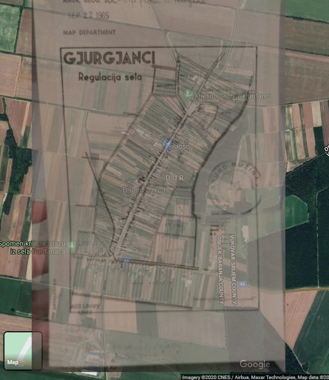
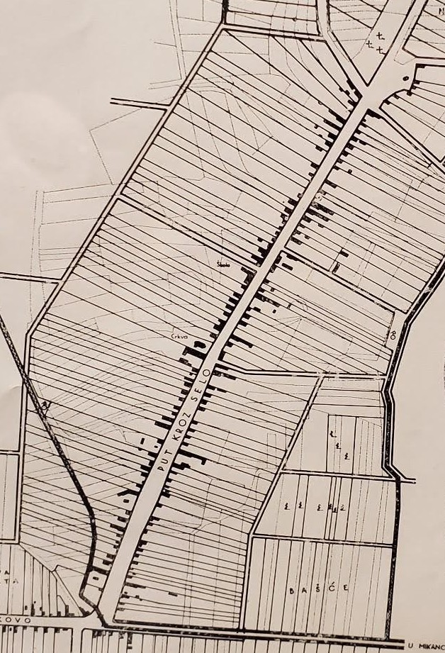
Recently I’ve been cataloging a back log of maps from Eastern Europe. If you’re familiar with the AGS Library’s situation, all our maps are cataloged – in an old fashioned card catalog. Efforts have been underway for … a long time … to get everything cataloged in the online environment. The other day I ran across this little map titled “Gjurgjanci Regulacija sela” (24 x 16 cm). After some detective work, I was able to identify the modern place name and some other interesting information about it.
A Google search for “Gjurgjanci” – took me to a place in Kosovo, but the details didn’t match. Gjurgjanci doesn’t show up in the Getty geographic thesaurus, the U.S. Board on Geographic Names or the Library of Congress subject heading authorities, so my detective work continued.
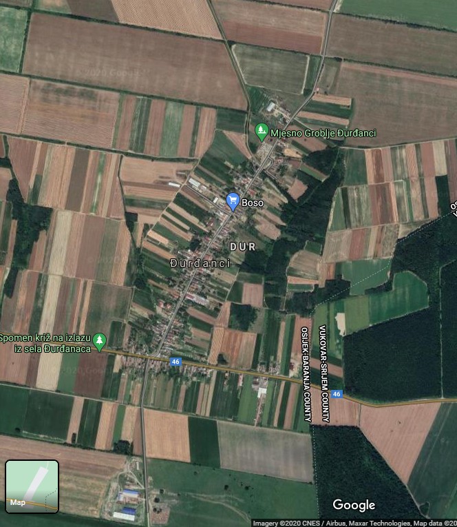
On the map, I noticed that some roads are labeled with directions to neighboring cities. I searched those place names until I zeroed in and identified the correct location of my map – Đurđanci in the county of Osijek-Baranja, Croatia.
It was great to learn WHERE the map was of, but I still didn’t know anything else about it such as subject, date or publisher. I cataloged that map as best I could and continued on my cataloging journey through Yugoslavia.
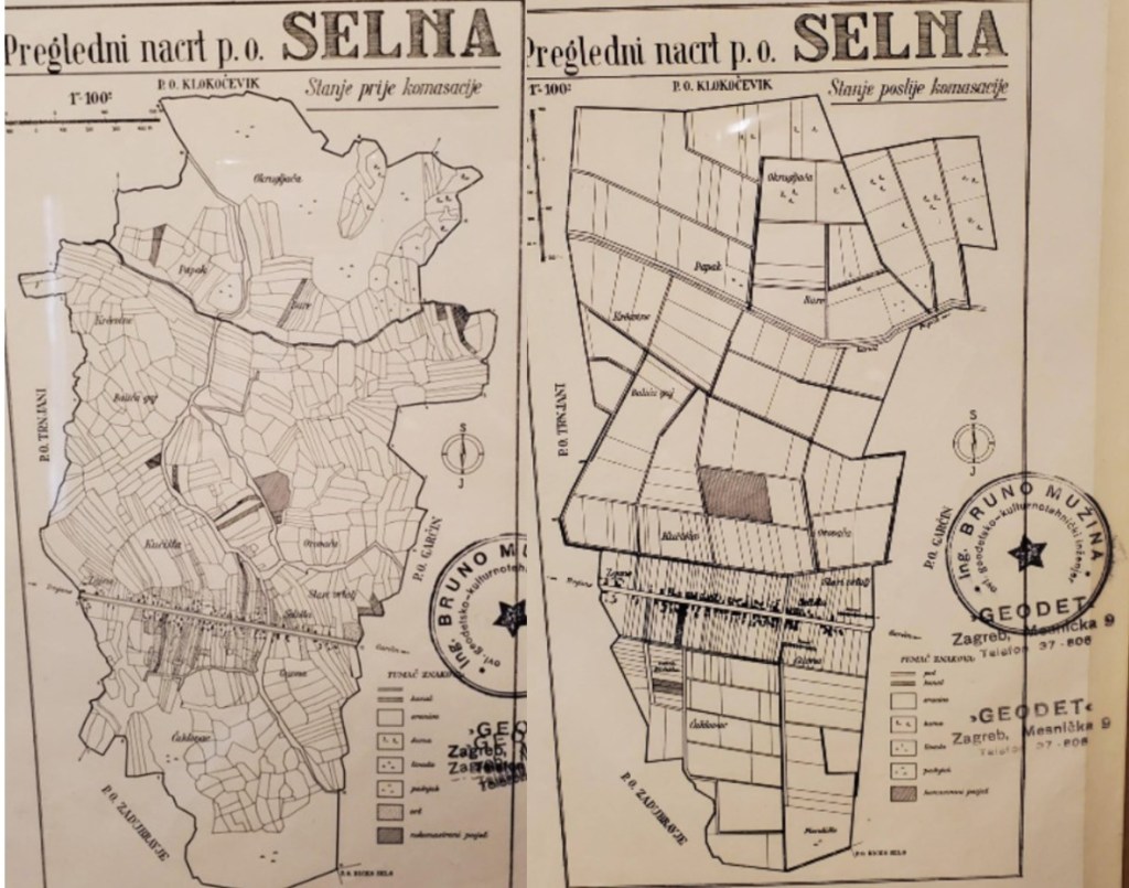
The next day I came across two similar maps with similar problems – I was not able to find the place name in a Google search, a Getty geographic thesaurus search or a Library of Congress subject heading authorities search.
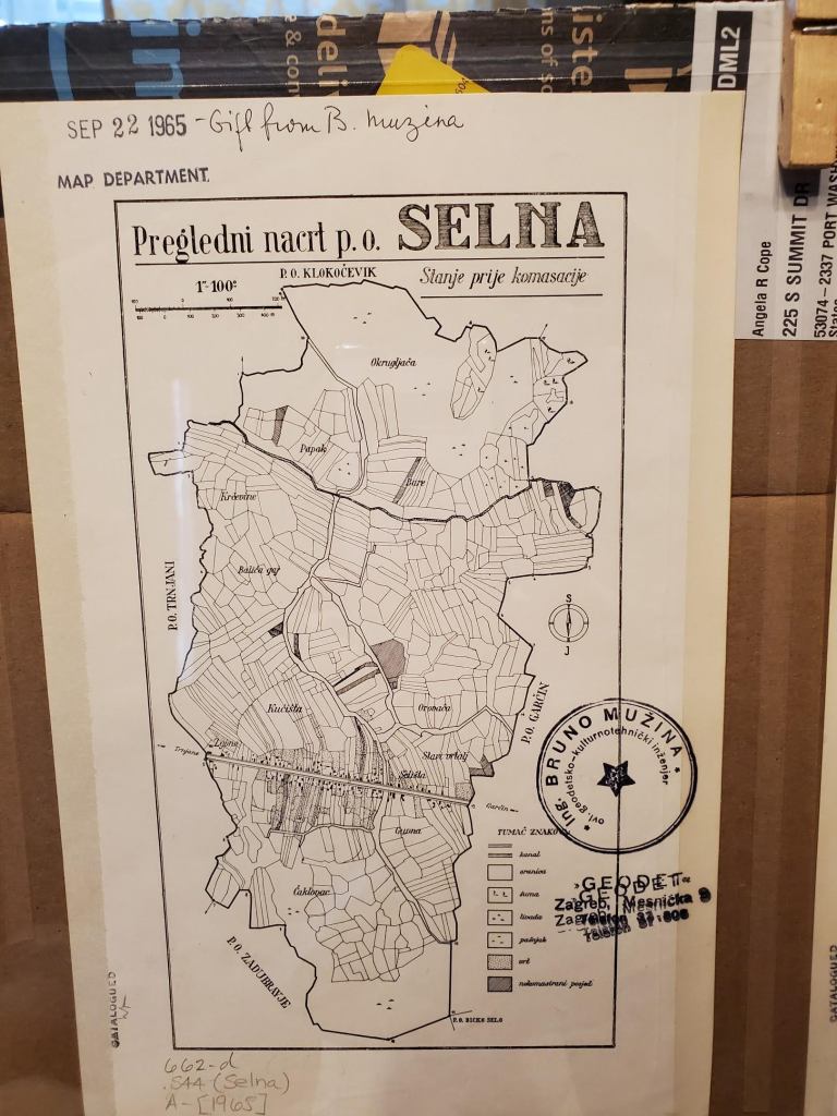
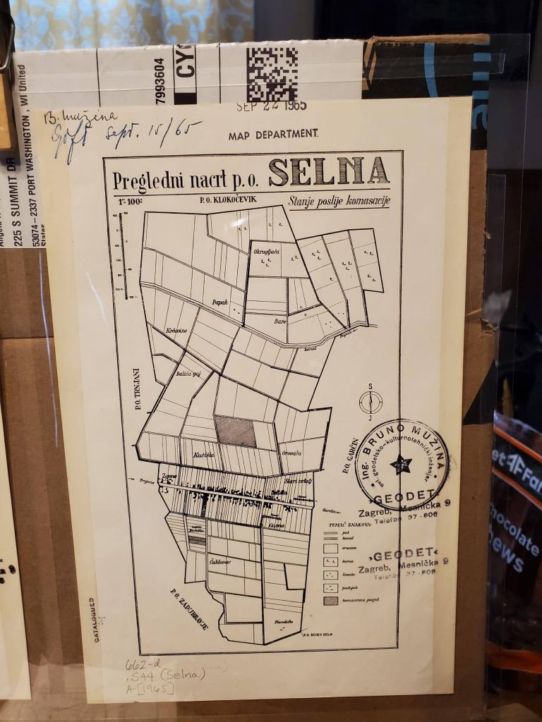
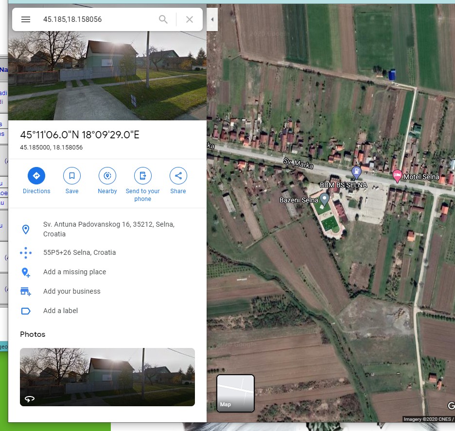
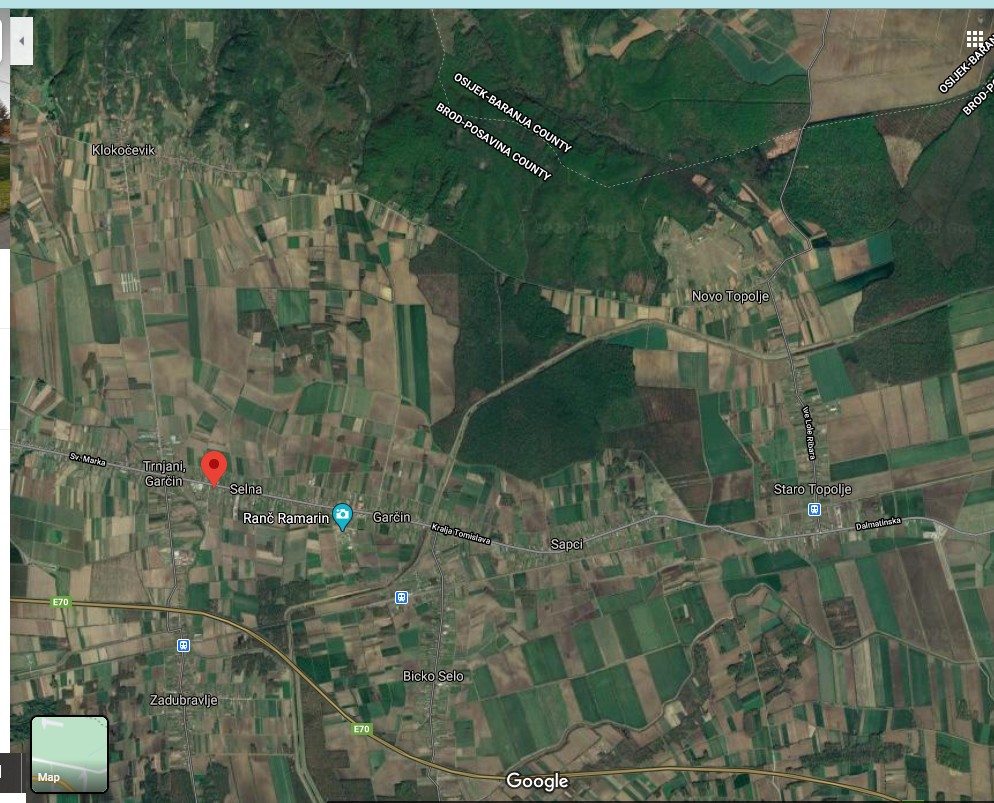
Fortunately, in this case, the US Board on Geographic Names site included a record for Selna. The search results at US Board on Geographic Names allow you to click on a link to the map. You can see the modern map lines up with details from these historical paper maps.
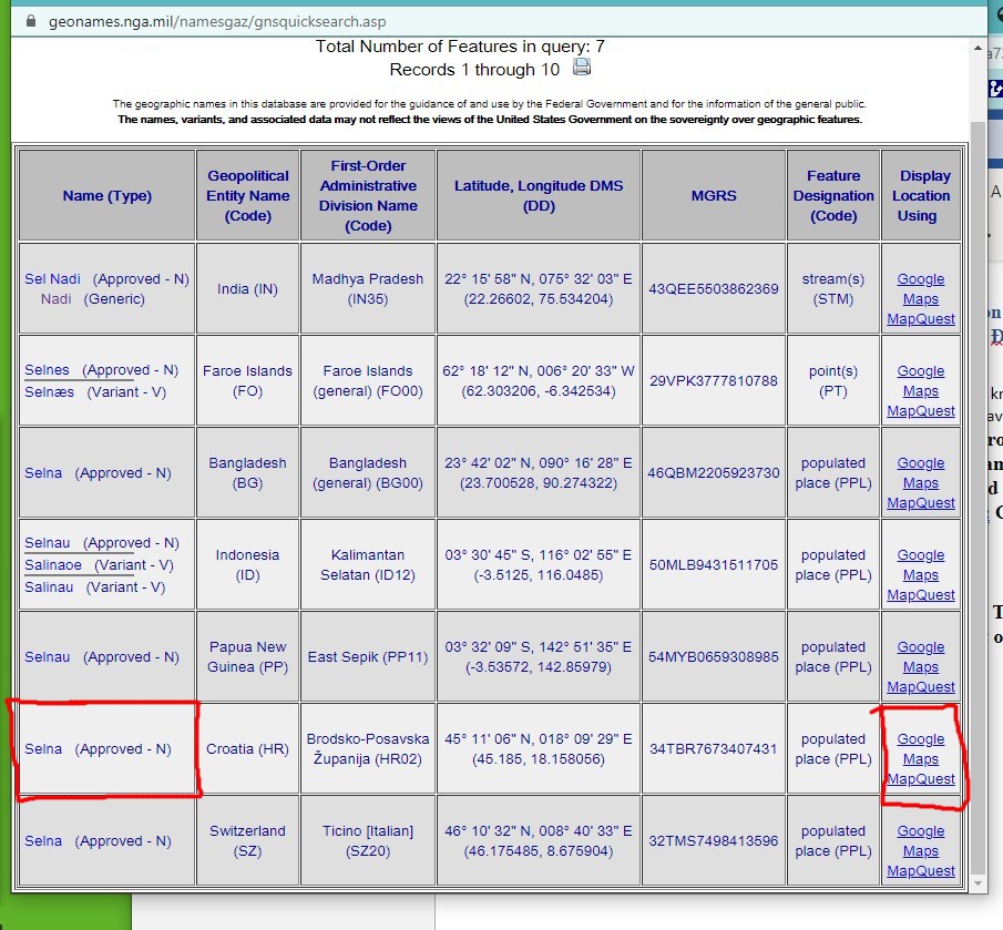
While I still don’t know much about these maps in regard to their date or publisher, I was able to learn that these maps show Croatian/Yugoslavian land consolidation. The subtitles on the Selna maps read: Stanje prije komasacije — Stanje poslije komasacije or Condition before consolidation – Condition after consolidation.
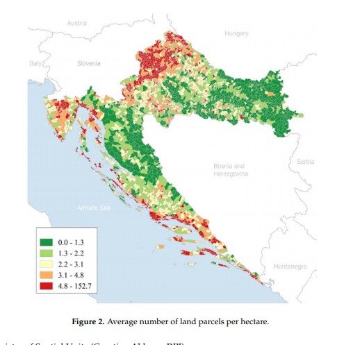
Apparently there have been multiple attempts to consolidate land in Croatia. Today, Croatia has approximately 14 million cadastral parcels and the total land area is 56,594 km2. Cadastral parcels are heavily fragmented (Figure 2). From the figure it is visible that average number of land parcels per hectare is relatively high.
Faculty of Geodesy, University of Croatia. Published: 9 March 2018
The maps held at the AGS Library were received as gifts from “Ing. Bruno Muzina ovl. Geodetsko-kulturnotehnički inženjer” in 1965. My guess is that he worked at “”Geodet” Zagreb, Mesnička” as indicated by the stamps on the maps. The publication date is at least 1965 or earlier based on the gift date. However, I don’t know an exact date or publisher or if the maps were removed from a report and if so, what report.
With this added knowledge, the details of the maps become quite interesting. The first map of Gjurgjanci/ Đurđanci has the consolidated property lines layered over the historical, fragmented parcels. The Selna maps have the two versions side by side. One can clearly see the fragmented historical parcels. The idea is that fragmented agricultural land raises the cost of agricultural production. The land consolidation effort would merge partitioned lands into larger and more regularly shaped parcels. Roads and canal networks would also be arranged to improve the conditions of agricultural production. Understanding a little more about both the where and the what my maps were showing is critical when assigning subject headings. In this case, I assign both the place names as well as a topical heading: Consolidation of land holdings — Croatia — Maps.
As a cataloger I make decisions about how far to proceed when creating data for my records. Do I continue to research this question, learn the Croatian language so I can read up on land consolidation, travel to Croatia to comb the local archives, conduct a séance? Or, do I make the decision to put as much information as I can, make educated guesses, include information in brackets and just move on with my life (see one of my cataloging records below).
Perhaps this blog will be seen by someone out there who can offer information about the publisher or date of the land consolidation being shown on my maps.
hashtags to consider … #workingfromhome #https://pixlr.com/x/ #pixlr_is_awesome #gettingbywithphonephotos #googlemapsrock #ilovecataloging
007 a ǂb j ǂd a ǂe a ǂf n ǂg z ǂh n
040 GZN ǂb eng ǂe rda ǂc GZN
0341 a ǂb 10000
043 e-ci—
090 ǂb
049 GZNA
24500Gjurgjanci Regulacija sela.
255 Scale approximately 1:10,000.
264 1[Place of publication not identified] : ǂb [publisher not indentified], ǂc [1960?]
300 1 map ; ǂc 18 x 13 cm, on sheet 24 x 16 cm
336 cartographic image ǂ2 rdacontent
337 unmediated ǂ2 rdamedia
338 sheet ǂ2 rdacarrier
500 Stamped: Ing. Bruno Muzina ovl. Geodetsko-kulturnotehnički inženjer.
500 “Gift from B. Muzina, Sep 22 1965.”
500 Đurđanci, Osijek-Baranja County, Croatia.
6500Consolidation of land holdings — Croatia — Đurđanci — Maps
651 0Đurđanci (Croatia) ǂv Maps.
650 0Cities and towns ǂz Yugoslavia ǂv Maps.
650 0Cities and towns ǂz Croatia ǂv Maps.
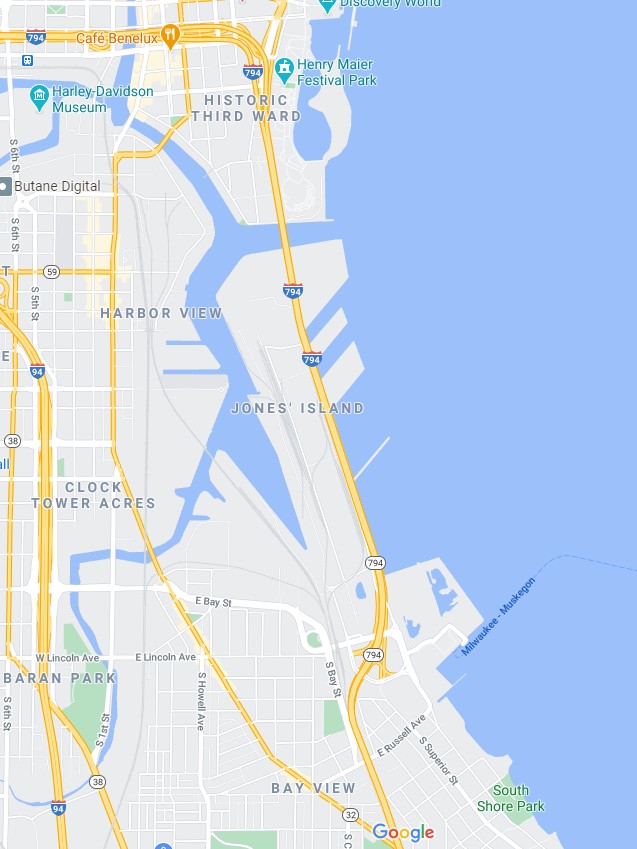
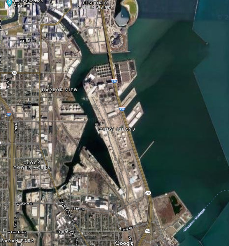
Jones Island, Milwaukee, Wisconsin
by Angie Cope
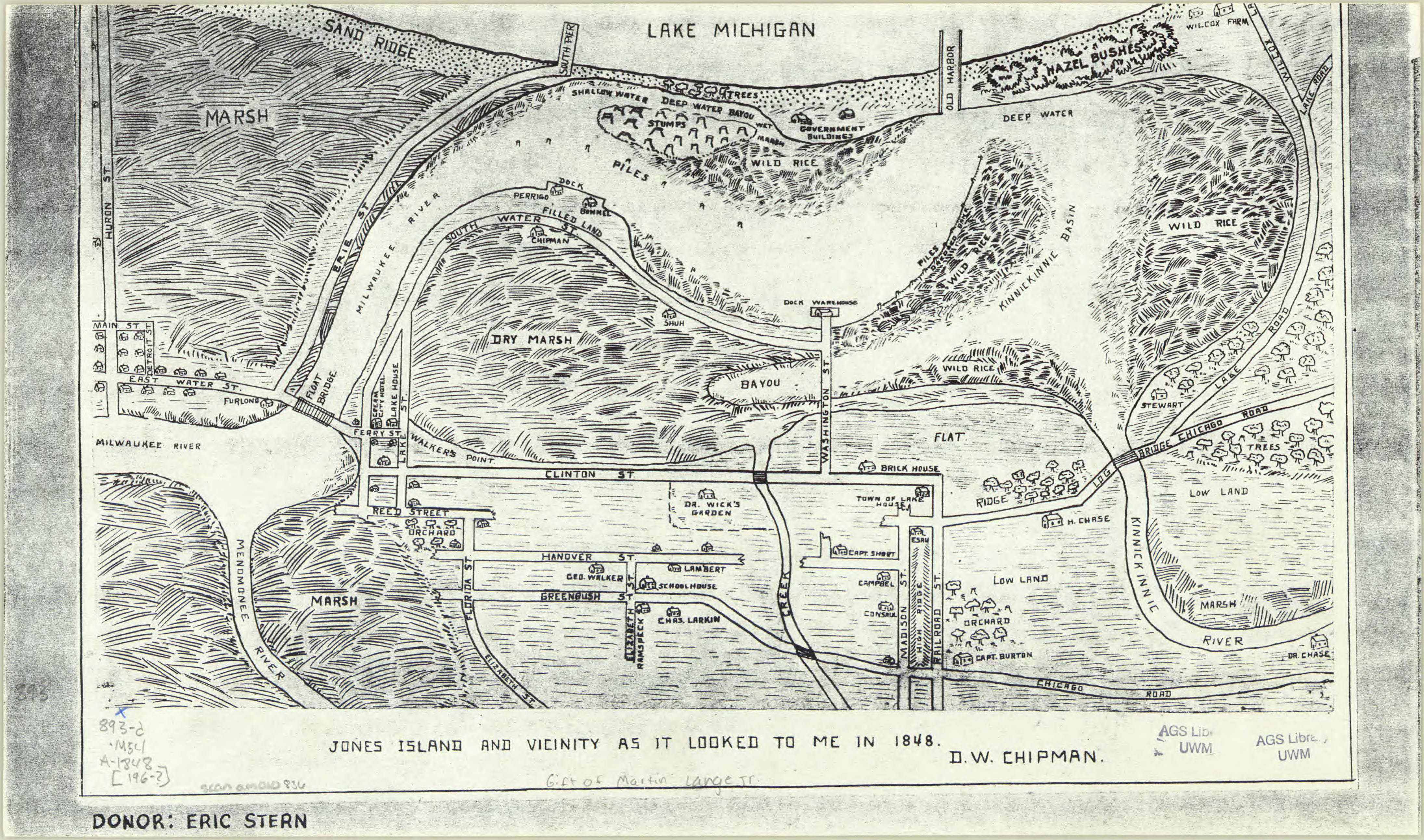
Jones island is an industrialized peninsula in Milwaukee, Wisconsin between the Milwaukee and Kinnickinnic rivers.
https://collections.lib.uwm.edu/digital/collection/agdm/id/5459/rec/1
The island was originally marsh land when German immigrants settled there in the 1870s. Without proper land deeds, the immigrants were considered squatters and were evicted to make way for a shipping port. Between 1920 and 1940s the final European immigrants were removed.
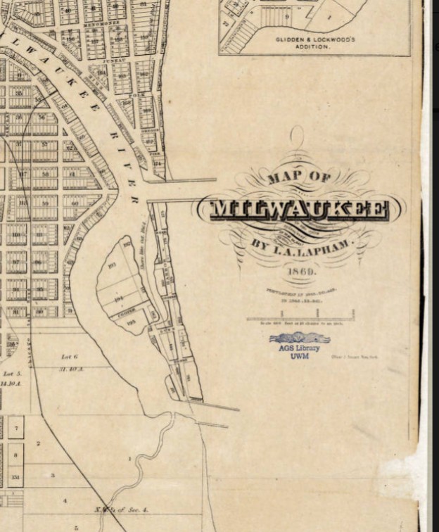
https://collections.lib.uwm.edu/digital/collection/agdm/id/21/rec/7
Today Jones Island is home to the Port of Milwaukee, the Milwaukee Metropolitan Sewerage District’s primary wastewater treatment plant, and other municipal services. It also supports the long-arch Hoan Bridge that spans across the Milwaukee River inlet. The land is heavily industrialized, containing only a couple of mature trees.

Map of Jones Island 1960s facsimile of an 1848 map
https://collections.lib.uwm.edu/digital/collection/agdm/id/5459/rec/1
View of Jones Island from an 1869 map of Milwaukee
https://collections.lib.uwm.edu/digital/collection/agdm/id/21/rec/7
Modern map of Jones Island, Milwaukee, Wisconsin 2020
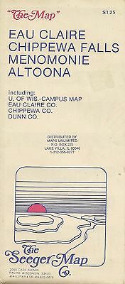
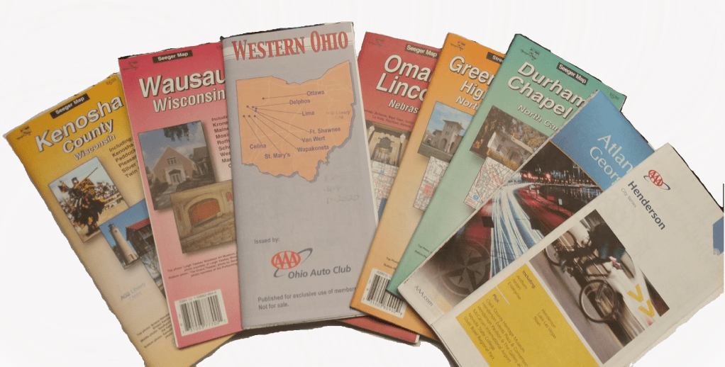
End of an era — The Seeger Map Company, Inc. closes their doors
by Angie Cope
The Seeger Map Company, a mainstay in the map world, announced it will be closing the business by the end of 2020. The first Seeger maps were those drawn for motel guests on scraps of paper in the late 1960s. Eventually, the company would distribute 2 million maps a year and employ 27 people in their Racine, Wisconsin offices. One thing is for sure, the enduring legacy of Seeger Map Company will live on in homes and libraries across the United States, and abroad.
Norman Seeger Sr. was a sergeant with the Racine Police Department and he also built the Seeger Motel on Durand Avenue in Racine, Wisconsin.* The motel catered to visiting business people who frequently asked for directions. No local map of Racine existed, so Norm Sr. sketched directions on a piece of paper. He wearied of that task and started passing out mimeographed copies to his guests.
From the beginning, Norman Sr. was assisted by his son, also named Norman. They saw an opportunity to provide local maps and partnered up with Ed Raymond who had been printing specialty products for banks, realtors, hospitals and churches. Seeger and Raymond produced their first map of Racine with advertisements and coupons in the margins. The business was called “Seeger’s Local Map & Directory Company” because a page sized directory/index was included with the map.
In the early days the business was part time and most activity happened during the summers when Norman Jr. wasn’t busy with his teaching job. Norman Jr. attended Dominican College and Purdue University and taught chemistry, math and computers at St. Catherine’s School in Racine. The business was a family affair involving children, a niece and many family friends. A light table and all the accompanying manual tools were set up in the basement of the family home. A family friend engineered a device that created plastic wrappers for the maps and then family members packaged and labeled maps for distribution. In the early 1970s, Norman Jr. contacted the geography department at Carroll College to hire a cartographer to help create some of their first maps of Waukesha, Milwaukee and Madison.
The early maps were blue and red ink on white paper. Printing of maps was handled by Angel Lithographing, Burton & Mayer and Badger Printing.
By 1980, the business became more than the family basement could handle and the company purchased the 401 Main Street building in Racine. By this time, Dan Bartelt had been hired as the company’s first non-family employee and he helped aid the transition from the basement to a successful company. Eventually, Seeger purchased 403 Main Street as well to accommodate the growing business.
Norman Jr. wasn’t one to jump on the latest fads and trends but did eventually adopt the use of technology for his map making. He worked with Waukesha County friend Dave Stack to build a Computer Aided Drafting (CAD) program that transitioned the company from paper to digital.
Another milestone for the Seeger Map Company occurred in the late 80s when they began to design and produce maps for customers outside Wisconsin for the Ohio Auto Club, and for the Franklin County, Ohio, Engineering Department. In the early 90s a landmark relationship was launched when the Carolinas Motor Club contacted Seeger for map design. Affiliation with the American Automobile Association (AAA) soon followed and the relationship quickly grew to included other state and national level clubs. Eventually, more than 80% of Seeger’s business was with the AAA clubs.
Norm Jr. resigned his teaching position in 1989 to become the sole owner of Seeger Map Company and to devote his full attention to the company. At the height of the company’s success in the mid-1990s, they employed 27 people and produced 2 million maps a year. The company still employed family members such as Norm Jr.’s daughter Becky who paid her way through college as an indexer, a task she did completely manually. Norm Jr. and his wife Carol scheduled their family vacations around map making. They’d drive up and down the streets of places like Branson, Nashville and Gatlinburg recording business names and points of interest. Norm and Carol wrote their notes on enlarged printouts of Seeger maps that they’d then give to the cartographers to update the computer files. Examples of these manuscript maps will be housed at the American Geographical Society Library at UW Milwaukee.
By the 2010s, Norm Jr. had semi-retired from the company and left the daily operations in the capable hands of Dan Bartelt and the cartographers, and Sandi Knorr, the company Administrator. Unfortunately, Bartelt passed away unexpectedly in 2013 at the age of 55. Norm Jr. had to come out of retirement to restructure the business. He never did quite fully get to retirement before he died in 2018. According to Norm Jr.’s wife Carol, he was nonetheless happily reaping many benefits of years of hard work and wise investments that came from running a successful business.
The American Geographical Society Library holds over 700 maps made by The Seeger Map Company, Inc. and there are over 3,000 titles held at libraries from around the world according to worldcat.org. Seeger succeeded while other paper map companies gave way to the changing times. Norman Seeger Jr. and The Seeger Map Company are respected names in local, regional, and national cartographic production. To say that their legacy will live on, is an understatement.
A special thank you to Becky Seeger Jenn and Carol Seeger for speaking with the author and sharing their stories.
*The motel was built in 1960 by Norman Seeger Sr. and his wife. The name was changed in 1970 to The Seeker Motel when ownership changed to Mervin Brandt, who had previously served as Pewaukee village president. Brandt died in 1975. The motel still rents rooms today, just a few blocks from the lakefront.
_____________________________
https://collections.lib.uwm.edu/digital/collection/agdm/id/12691/rec/2 
https://collections.lib.uwm.edu/digital/collection/agdm/id/12691/rec/2
_____________________________

According to the following table, compiled by Joe Tomich, Librarian at UW Milwaukee Libraries, there are 2,994 Seeger Map Co. maps in WorldCat. The Library of Congress has been receiving copies of Seeger maps and holds 1,669 (cataloged, likely some uncataloged as part of their backlog). The AGS Library at UWM holds 788 Seeger maps.
Because many of Seeger’s early maps didn’t list a date, catalogers guessed at a date and the same map may have been cataloged more than once but with different dates.
You can view or download the following table as a pdf file.
A list of all the companies and organizations affiliated with Seeger Map Company, Inc. over the years (click on image for a larger view).

PDF version of this list:
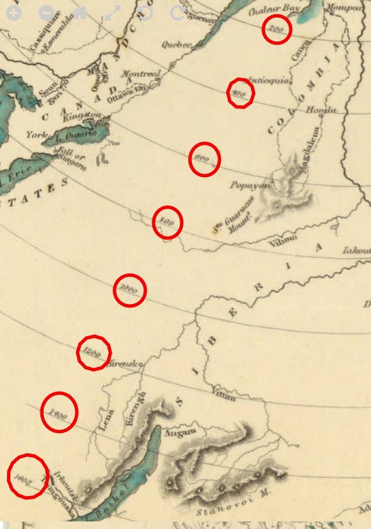
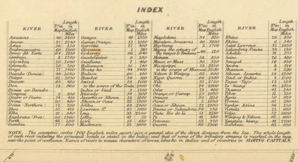
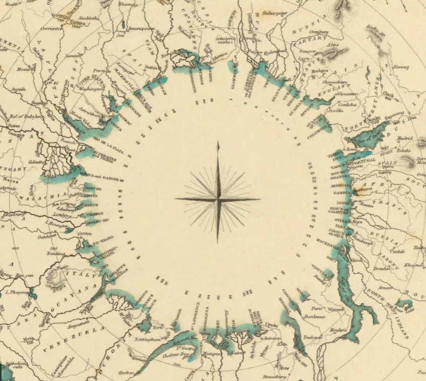
Comparative river chart by the Society for the Diffusion of Useful Knowledge
This chart shows the general lengths of 92 of the great rivers of the world.
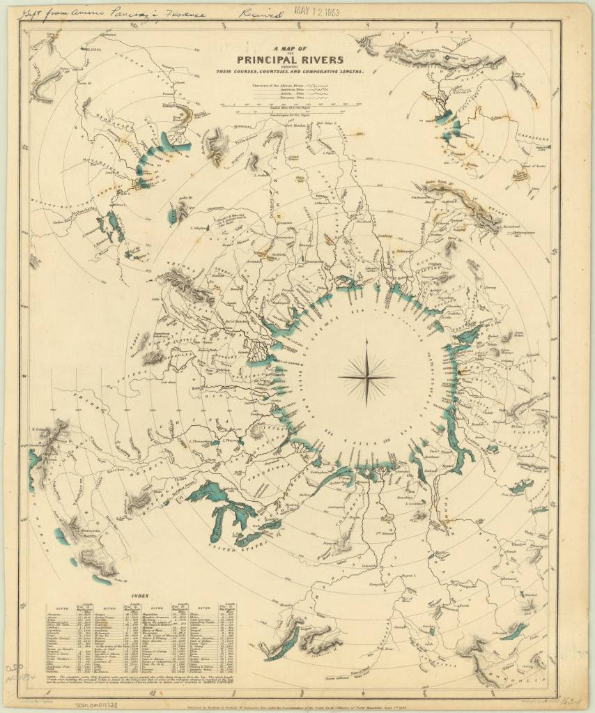
A map of the principal rivers shewing their courses, countries, and comparative lengths / published by Baldwin & Cradock, under the superintendence of the Society for the Diffusion of Useful Knowledge ; engraved by Thos. Starling, 1834. https://collections.lib.uwm.edu/…/agdm/id/5294/rec/1
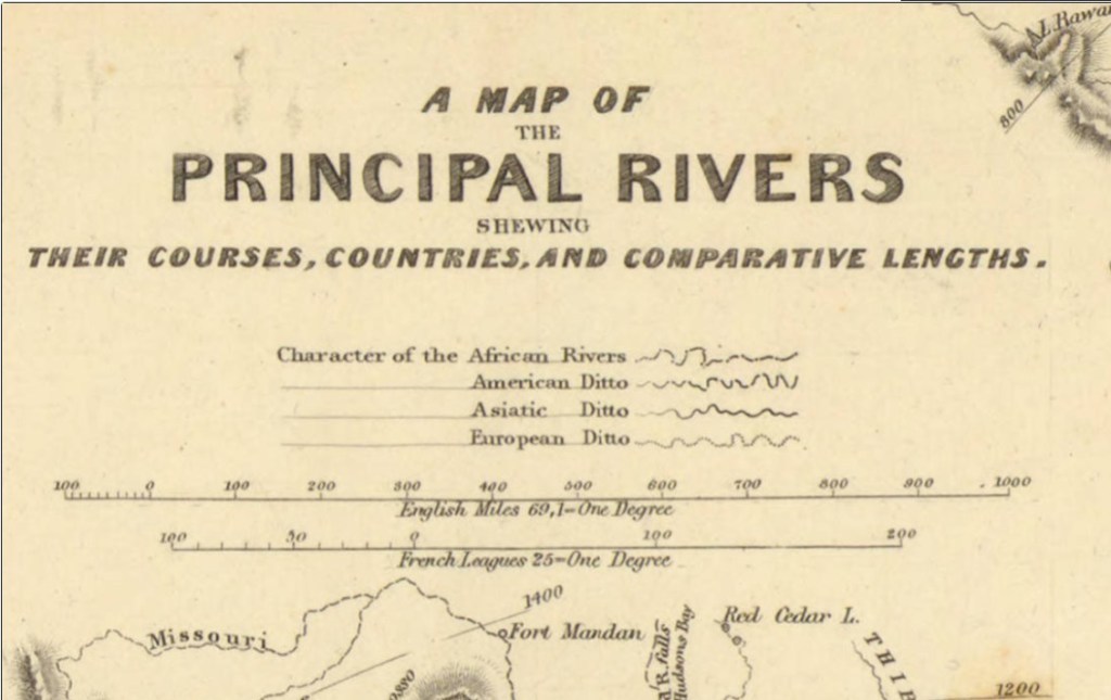
Concentric circles depict approximate distances, with exact lengths given in the index in the lower left.
Shading and hachures are used to shows selected mountains and volcanoes. There are actually 3 diagrams within this chart – 2 smaller diagrams are hidden in the top 2 corners.
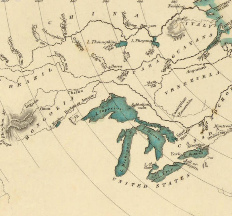
A lovely compass rose graces the center of the chart.
The Society for the Diffusion of Useful Knowledge (SDUK) was a London-based organization dedicated to the dissemination of self-education materials for individuals without access to formal education. SDUK was founded in 1826 at the urging of Lord Brougham, who became Lord High Chancellor of Great Britain. The Society also published the Library of Useful Knowledge, which was a series of accessible scientific books published biweekly. The SDUK aimed to provide working-class people with access to knowledge at an affordable price.
The style of comparative chart shown here never became popular in geographic education. Instead, charts showing comparative mountains and rivers were used in geography texts.
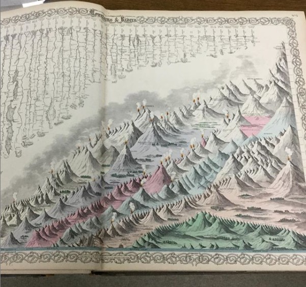
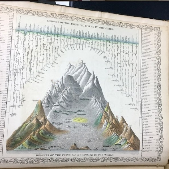
A wonderful book was published in 2019 on just this topic.
An atlas of geographical wonders : from mountaintops to riverbeds : a selection of comparative maps and tableaux / Jean-Christophe Bailly, Jean-Marc Besse, Philippe Grand, Gilles Palsky. New York : Princeton Architectural Press, 2019.
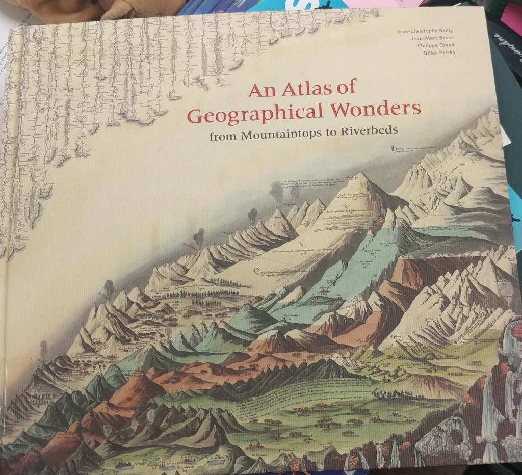
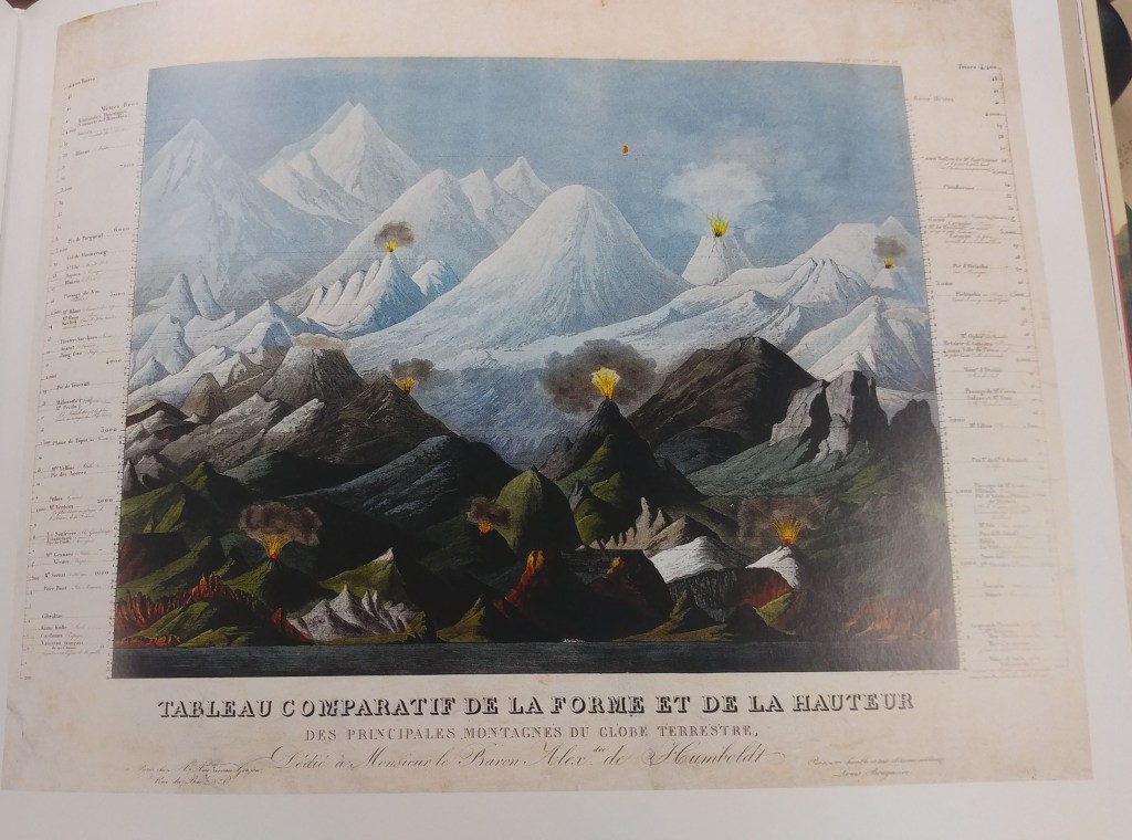
This is the first book to catalog comparative maps and tableaux that visualize the heights and lengths of the world’s mountains and rivers. Produced predominantly in the nineteenth century, these beautifully rendered maps emerged out of the tide of exploration and scientific developments in measuring techniques. Beginning with the work of explorer Alexander von Humboldt, these historic drawings reveal a world of artistic and imaginative difference. Many of them give way—and with visible joy—to the power of fantasy in a mesmerizing array of realistic and imaginary forms.
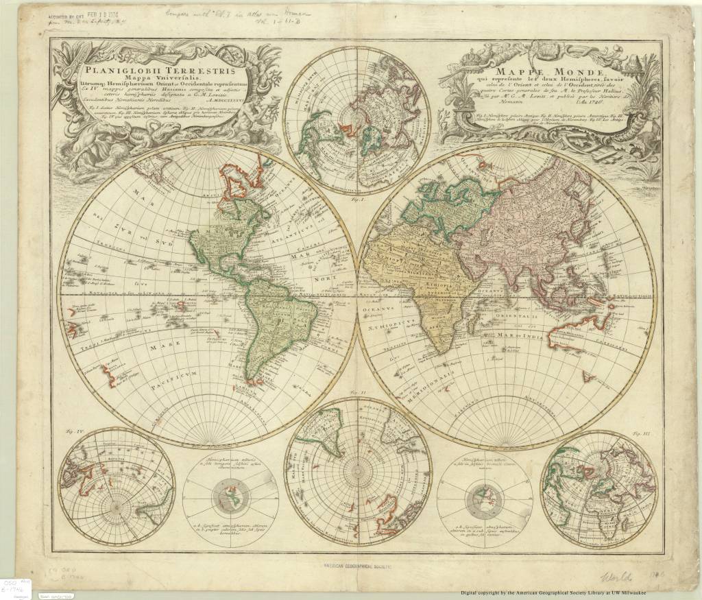
Planiglobii terrestris world map from 1716
by Angie Cope
Planiglobii terrestris cum utroq hemisphaerio caelesti generalis repraesentatio : quam ex novissimis probatissimisque recentium geographorum scriptis concinnatam, multisq[ue] phaenomenis illustratam / publice proponit Io. Bapt. Homann …
1716
Call number: Rare 050 A-[1716]
https://collections.lib.uwm.edu/digital/collection/agdm/id/1156
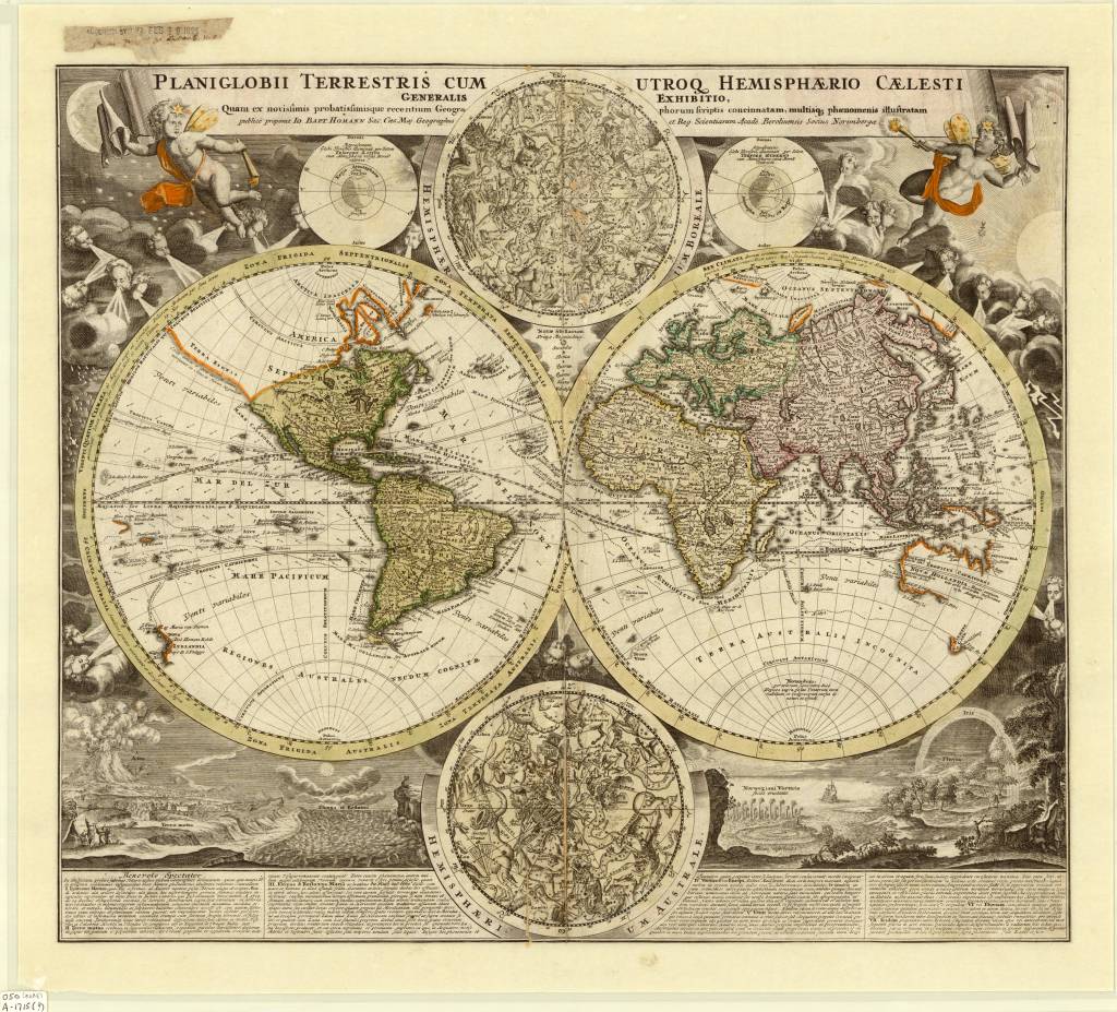
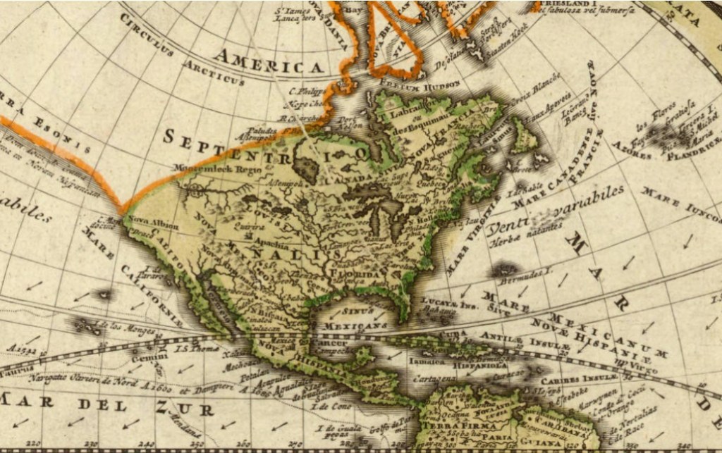
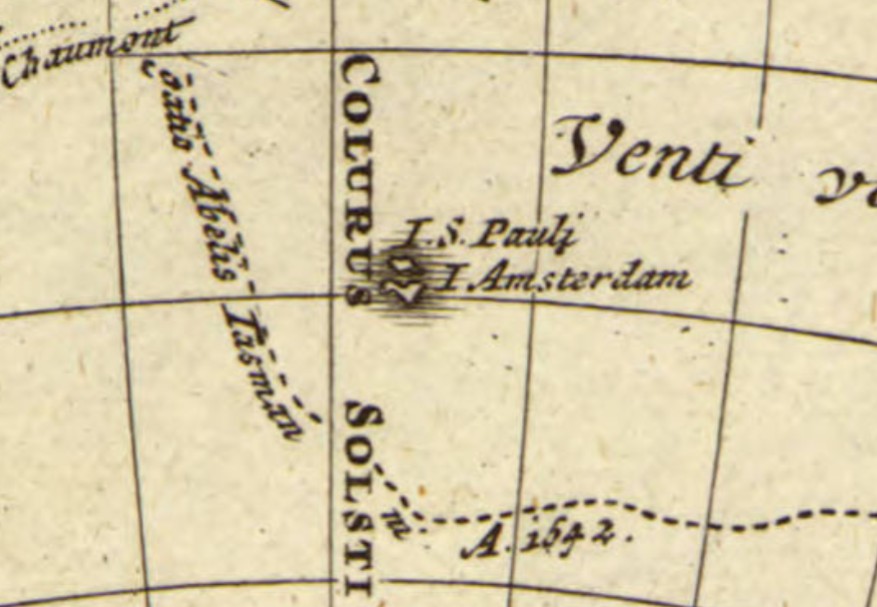
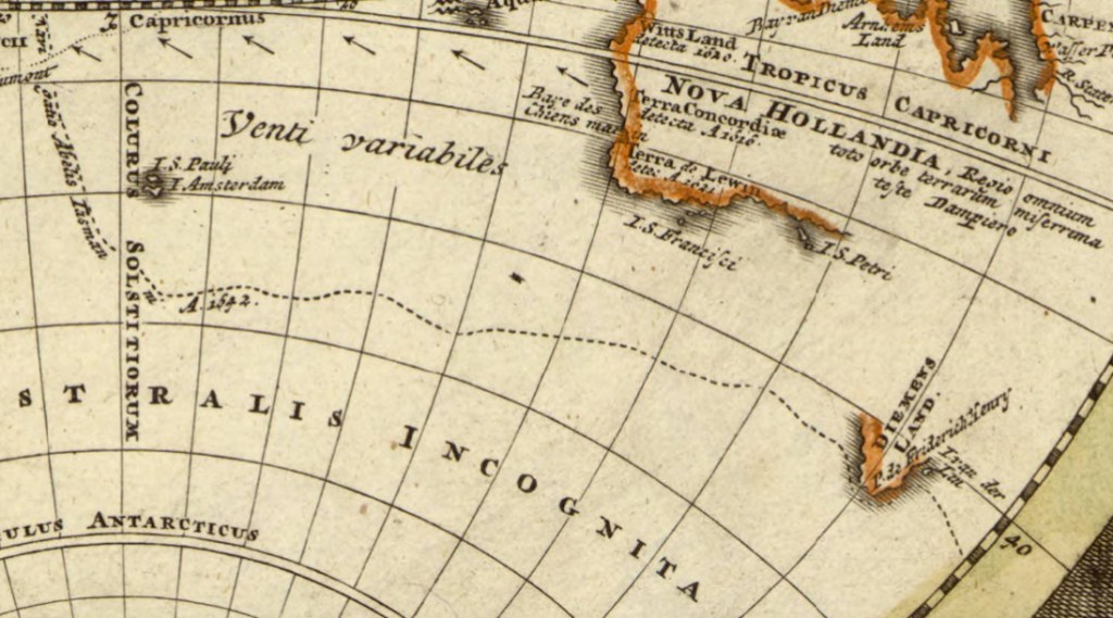
Here is a 1716 map by Johann Baptist Homann from a period in history when geographic knowledge was often unknown. The Australia, New Guinea and New Zealand coastlines are all incomplete, though they include some place names, notes of the early discoverers and tracks of Magellan’s (1522) and Tasman’s (1642) voyages.
Cartographic inaccuracies can be seen on this map such as the east-west trend of the northwest coast of North America, the distorted treatment of Japan, and the absence of an Antarctic continent. However, California does appear as a peninsula.
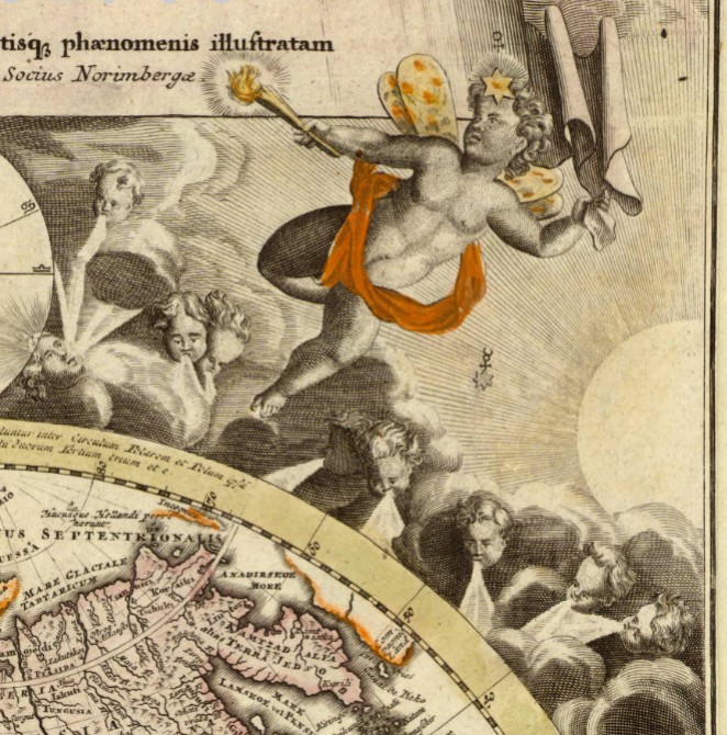
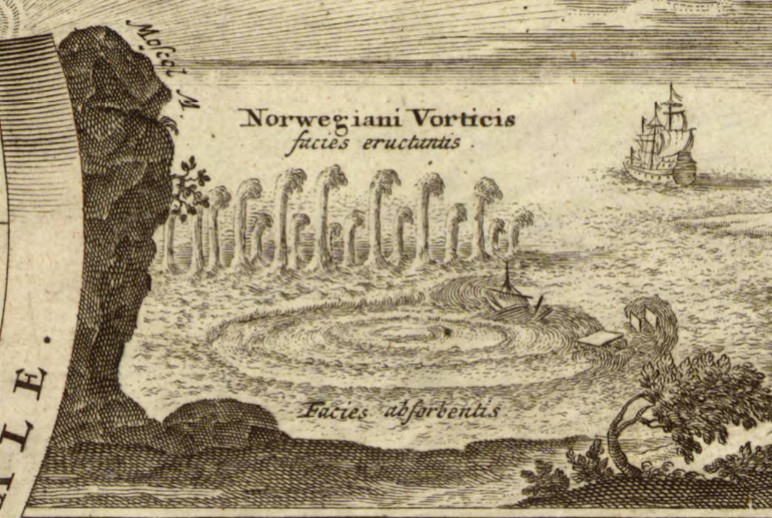
In spite of the inaccuracies, the map is appealing through the detailed use of decorative vignettes: two celestial hemispheres, an eruption of Mt. Etna, an earthquake, the tides, a whirlpool off the Norwegian coast, and diagrams explaining the seasons add interest. Numerous cherubs and windheads, representations of the stars, sun and moon and other decorative features also give the map added visual appeal.
Planiglobii Terrestris was produced by Johann Homann (1663-1724) and first appeared in his Neuer Atlas (1707). Homann was a leading figure in the scientific community of Nuremburg and the preeminent German cartographic publisher of his time.
This map came to the AGS of NY in 1924 as a gift from Mr. F.W. Lafrentz who also donated a 1746 Planiglobii Terrestris.
https://collections.lib.uwm.edu/digital/collection/agdm/id/1215/rec/1
- ← Previous
- 1
- 2
- 3
- …
- 5
- Next →
