Uncategorized
Preservation for the private collection
by Angie Cope
Librarians at the AGS Library are often asked about best practices for caring for private collections. A recent “conversation” at the EXLIBRIS rare and special collections discussion list generated many useful sources to help answer that question.


___________________________
American Institute for Conservation (AIC) – Caring for your treasures
Northeast Document Conservatin Center (NEDCC) – Preservation Leaflet Series
American Library Association (ALA) – Saving for your stuff (audio, film, books, data, textiles, paper, slides, photos, scrapbooks, artifacts)
Gaylord Archival – Guide to collections care
Gaylord Archival Resources
Archival 101: Dealing with Suppliers of Archival Product by Peter D. Verheyen
Bookcraft Book Repair Guide early editions are available via HaithiTrust
Photos from the AGS Library efforts of caring for our collection with some before and after photos.


")

")


18th Century Missional Maps in the Amazon Basin Exhibit at the AGS Library
April 26th was the Maps & America lecture sponsored by Arthur and Jan Holzheimer. The speaker was Dr. Carme Montaner, Head, Unitat Cartoteca de Catalunya, Institut Cartogràfic i Geològic de Catalunya, Barcelona. Her talk “18th Century Missional Maps in the Amazon Basin: The Case of Ocapa Monastery in Peru” was accompanied by an exhibit of materials from the AGS Library as curated by Jovanka Ristic.
Here are photos from the exhibit. Click on any image to open a larger view.


Posted by Angie Cope
The AGS Library at UW-Milwaukee: celebrating 40 years
In August of 1978, Milwaukee welcomed the American Geographical Society (AGS) Library to its new home at the UW-Milwaukee Libraries. Our exhibits for this special anniversary year will highlight the library’s activities and achievements over the last 40 years. The first exhibit is devoted to the publications of the AGS Library.


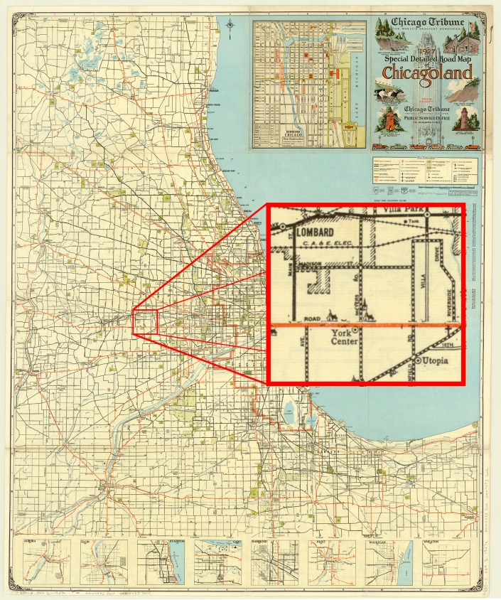
1927 Chicago Tribune Map of Chicagoland
by Judy Aulik

The Milwaukee Journal was not the only Midwestern newspaper giant to publish road maps. But unlike the Journal, the Chicago Tribune still has maps produced in its behalf, albeit by Rand McNally. The folding style of Chicagoland map was a mainstay of Illinois drivers for many years. It developed some delightful idiosyncrasies, such as the locations of radio broadcast transmitter towers, but at this early date, the “Trib map,” as called by residents, only showed some colleges, religious institutions, cemeteries, parks, and golf courses as landmarks and destinations. In addition, on this 1927 edition, US highways were designated by the route number in a red circle, instead of the shields used by the Rand McNally portion.
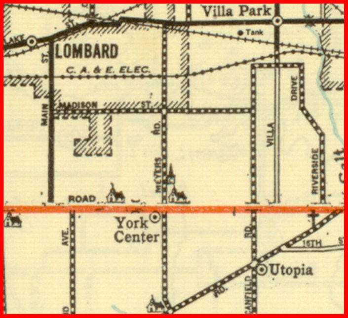
What is noticeable is the number of communities which have ceased to exist. Northeastern Illinois is notable for the number of communities denoted by the railroad stations on the major lines, spaced at fairly regular intervals. For example, on the C.B.&Q. (now the BNSF, or Burlington Northern & Santa Fe) were communities such as Belmont, now part of Downers Grove; Eola, now part of Aurora; and Lovedale, no longer extant.
Communities located on highways were not immune. On Roosevelt Road, once US 30A and today IL 38, was York Center, still denoted by churches but incorporated into Lombard. On Butterfield Road, parts of which have become IL 56, was Utopia, which is today’s Oakbrook Terrace, famous for its vast stretches of shopping malls.
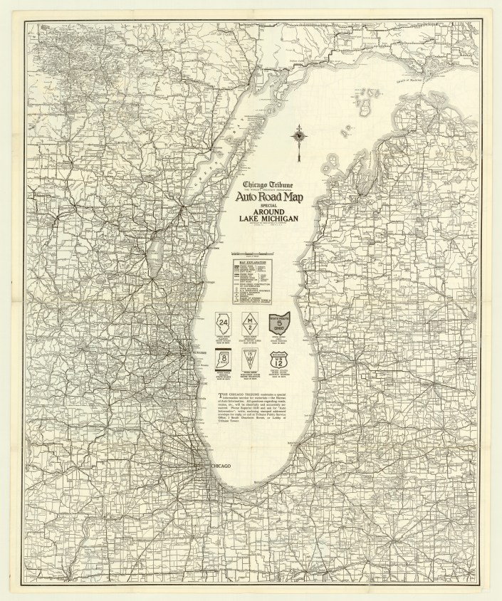
Interestingly, the reverse, a map of the states contiguous with Lake Michigan, shows us that the Tribune‘s relationship with the Chicago map giant dates back to the earliest map of the series. “Rand McNally” above “Auto Road Map” is replaced by “Chicago Tribune: The World’s Greatest Newspaper,” but with the characteristic compass rose, cartography, and copyright statement, no one would be fooled. In addition, I have a 1927 Illinois map, issued by the Tribune, but published by Rand McNally.
From a collector’s standpoint, the Chicagoland maps are common, but very difficult to find in acceptable condition. The vast majority are misfolded, heavily worn, and many are taped together, proof of the maps’ popularity. Probably due to the growth of the region–the Tribune maps did not show land beyond the Fox River–the Chicagoland map ceased publication sometime in the 1990s, with one last 2000 map. Even today, I carry a Tribune/Rand McNally 7-county street guide in my car when traveling, despite GPS. It lacks the charm of the old maps, but still gets the job done–until the next round of highway construction.

View the map in the AGS Library Digital Map Collection here
Engaging Users through Social Media
The AGSL Instagram hit 1,000 followers this December!
The account began in February 2016, and has since made over 200 posts. Students and staff alike share photo and video content of maps, atlases, globes, nautical charts, historic images, library events, and occasional goings-on about digital data.
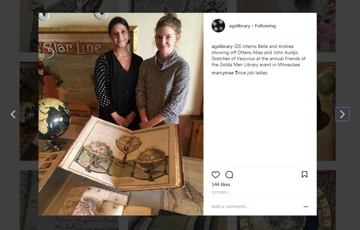
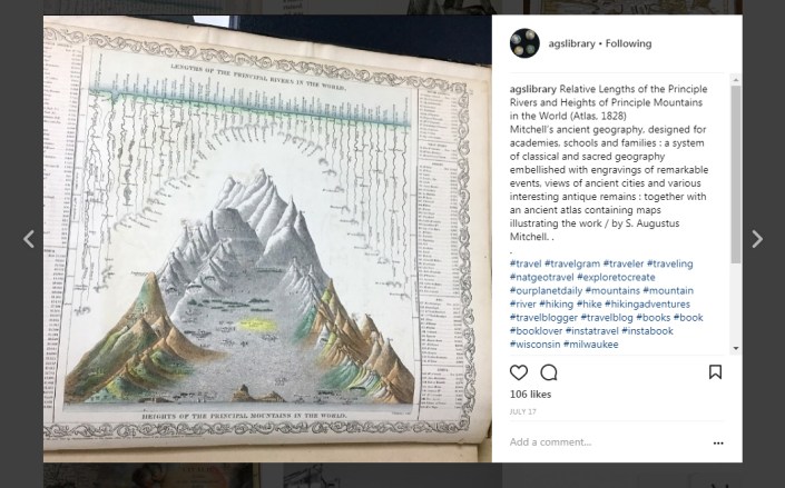
The theme of the account reflects many of the prominent themes of the AGS Library’s Collections: travel, adventure, exploration, and the boundless world. Visitors of the page are delighted by celestial globes and atlases depicting the night sky, and artistic flourishes on maps which add embellishment and distinguish the documents as more than mere navigational tools; especially popular are “Map Monsters,” who are scary, or sometimes silly dragon-esque creatures adorning the seas of some of the older maps in the AGS Library’s Collection.
An exciting benchmark for the AGS Library’s social media is a post from this past summer (2017) about Abraham Ortelius’ Map Monsters. The post reached over 1,100 notes on Tumblr!
Visitors likewise seem to enjoy maps and graphics which convey messages in unique and beautiful ways; the post with the most love is an image depicting comparative elevation of mountains in North America, coming from the Johnson Family Atlas of the 19th century (155 likes).
As promised, Stephen got the students an ice cream cake to celebrate reaching 1,000 followers at Instagram. December 20, 2017

Follow us @agslibrary on Instagram and at agslibrary.tumblr.com on Tumblr.
Instagram Account:
https://www.instagram.com/agslibrary/
Tumblr Account:
https://agslibrary.tumblr.com/
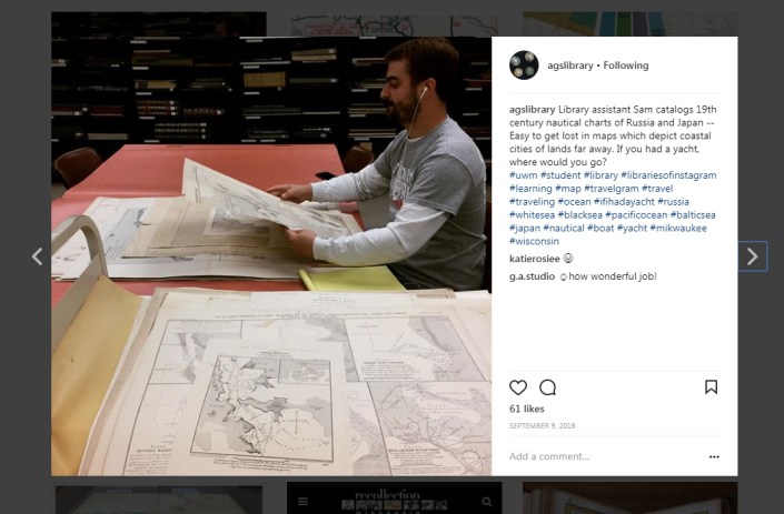
And finally, we celebrate the graduation and successful employment of AGSL student cataloging intern Sam Balistreri. Congratulations and best luck as you embark on your career.
Polar Exploration and the Hollow Earth
by Sam Balistreri-Daum
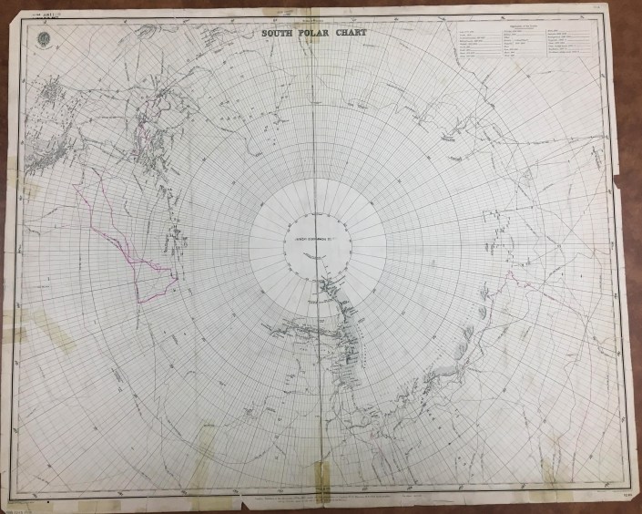
As I continued to catalog the British Admiralty charts this fall I was impressed by the way the AGS Library Nautical Chart collection in many ways shows the progress of exploration, especially in those last frontiers of the planet Earth, the Arctic and Antarctic Polar Regions. In today’s age of Google Maps and satellite imagery it becomes hard for us to imagine a time when every corner of the Earth was not known or explored. It still isn’t! Just think of the deepest parts of the oceans. So I decided I needed to learn more about what it was like in a time when polar exploration was at its most fervent if not urgent and theories, however crazy, were numerous as to what could be discovered at the poles.
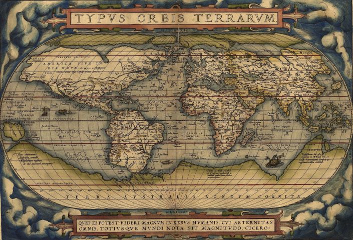
John Blake, in The Sea Chart: The Illustrated History of Nautical Maps and Navigational Charts (2016) gives a concise summary of the attempts to explore and reasons for the exploration of both poles. Exploration of the northern Polar Regions has a longer history than that of the South Polar Region, which is due to the “discovery” of America and the obsession of European explorers to find a Northwest Passage to Asia and India. Although a Northwest Passage does technically exist (during certain seasons), it is not a viable and profitable trade route. Interestingly, much of the exploration of both Arctic and Antarctic regions was made possible by an increased availability of British Naval vessels in the period following the Napoleonic Wars. Many of the names of ships and personnel responsible for these voyages such as William Parry, Commodore John Ross, Captains George Lyon and Frederick Beechey and His Majesty’s Ships Victory, Investigator and Enterprise to name a few can be found on the British Admiralty charts in the AGS Library collection. The Antarctic region around the South Pole, though explored much later, inspired much anticipation and excitement among explorers and colonizers as many European nations had far-flung colonial empires. Many early world maps and atlases, including Ortelius’ Theatrum Orbis Terrarum (1570) depicted large continents at the poles, especially the massive “Terra Incognita Australis” in the South Polar Region. There was even speculation that this large southern continent would have a temperate climate and would be populated with indigenous plants, animals and people. Imagine that! Realistic attempts at coastal exploration of what is today Antarctica did not occur until the Mid-19th Century and was often a byproduct of whaling and seal hunting expeditions.
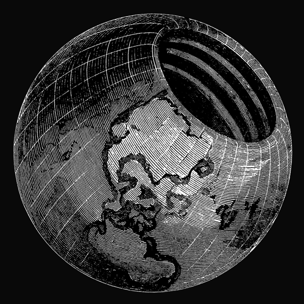
Remember how I said there were many theories about unexplored regions of Earth “however crazy”? Enter John Cleves Symmes (1780-1829), a military captain and veteran of the War of 1812. A timely listen to an episode of American history / comedy podcast The Dollop introduced me to Symmes and his theory. Symmes even spoke to the AGS in New York about his theory! Here at the AGSL we actually have a copy of The Symmes Theory of Concentric Spheres: Demonstrating That the Earth is Hollow, Habitable Within, and Widely Open about the Poles (1878) compiled by Symmes’ son Americus Symmes. They sure didn’t skimp on the title. The theory posits that the Earth is “globular, hollow, and open at the poles”, with a northern opening 2,000 miles in diameter and a southern opening that is “somewhat larger” (because why not, right?). The elder Symmes took his theory on the road, beginning in 1818 with an open letter calling for the exploration of the Arctic Polar Region to look for an opening, touring and lecturing until his death in 1829. Much like the speculation that a southern continent would have a temperate climate and be teeming with plant and animal life, the supposed hollow interior of the Earth according to Symmes would have a moderate climate and an abundance of flora and fauna. To Symmes and those convinced of his theory, the hollow Earth and its openings explained several phenomena including climate variation among various regions occupying the same latitude (for example temperate Europe vs. cold U.S. and Canada in winter), the Auroras (Borealis and Australis) and the counterintuitive migration patterns of various fish, bird and mammal species and groups of people. Want proof? Symmes claimed that looking at the example of Saturn’s Rings (discovered in 1610) proves that concentricity can exist. He also advanced the notion that not only Earth, but the rest of the planets in the solar system were probably hollow too. Including the sun! Needless to say Hollow Earth Theory doesn’t have much traction these days, except on the fringe where theories such as flat earth and the hollow moon (Aliens stole our moon and replaced it with a hollow one to spy on us?! Makes sense…) among others are alive and well.


The AGS Library is home not only to maps like the nautical charts that I have been working on cataloging during my time here, but a multitude of books, atlases and print materials that can be just as surprising as discovering the Earth is hollow.
Sources:
Blake, John. The Sea Chart: The Illustrated History of Nautical Maps and Navigational Charts. Conway/Bloomsbury, 2016.
Symmes, John Cleves. The Symmes Theory of Concentric Spheres: Demonstrating that the Earth is Hollow, Habitable Within, and Widely Open about the Poles/ compiled by Americus Symmes from the writings of his father, Capt. John Cleves Symmes. Bradley & Gilbert, 1878.
“Hollow Earth.” The Dollop from SoundCloud, 14 May 2015, https://soundcloud.com/the-dollop/80-the-hollow-earth
Century of Progress Maps
by Judy Aulik
Chicago, celebrating an ill-defined centennial, hit the 40th anniversary of its 1892-1893 World’s Columbian Exposition with the Century of Progress fair of 1933-1934. Map publishers went into overdrive to commemorate the first large World’s Fair of the auto tourism era. Oil companies which commissioned these road maps for their gasoline brands include Barnsdall, Conoco, Deep-Rock, Diamond, Gulf, Lubrite, Pennzoil, Pure, Shell, Standard (Indiana), and Vacuum Oil. Both H.H. Gousha and Rand McNally produced many road maps for the occasion: some were essentially Chicago vicinity maps with an inset of the lakefront fair grounds. Some bore specially designed covers, such as those from Barnsdall and Pure. Others showed routes with a symbol celebrating each exhibit hall. Even post card manufacturer Curt Teich published a commemorative road map for its hometown!
But not every attendee drove. Many used the railroads instead. The Chicago & Northwestern Railroad was an obvious choice for those west of the city. However, five electric line stations plus the Illinois Central’s Central Station served the Century of Progress and the museums.
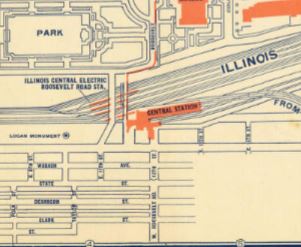
Although Chicago is a well-planned city, a city map and exhibit map would be welcomed by the tourist. In 1934, Illinois Central Railroad issued a Rand McNally map for this purpose.
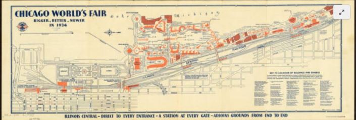
Oddly, this is oriented east-west as opposed to a road map. By this time, the convention of using the top edge of the sheet being north was nearly universal. Lake Michigan comprises its top edge.
The Century of Progress Deco exhibit buildings do not survive, with the exception of a House of Tomorrow, on Beverly Shores, Indiana. Since 1997, the IC rail yards are greatly reduced, and Millennium Park occupies some of the area shown on this map. IC’s Central Station is demolished, but Chicago’s lakefront was returned to the people.
Click here to view the AGS Library copy in the Digital Map Collection
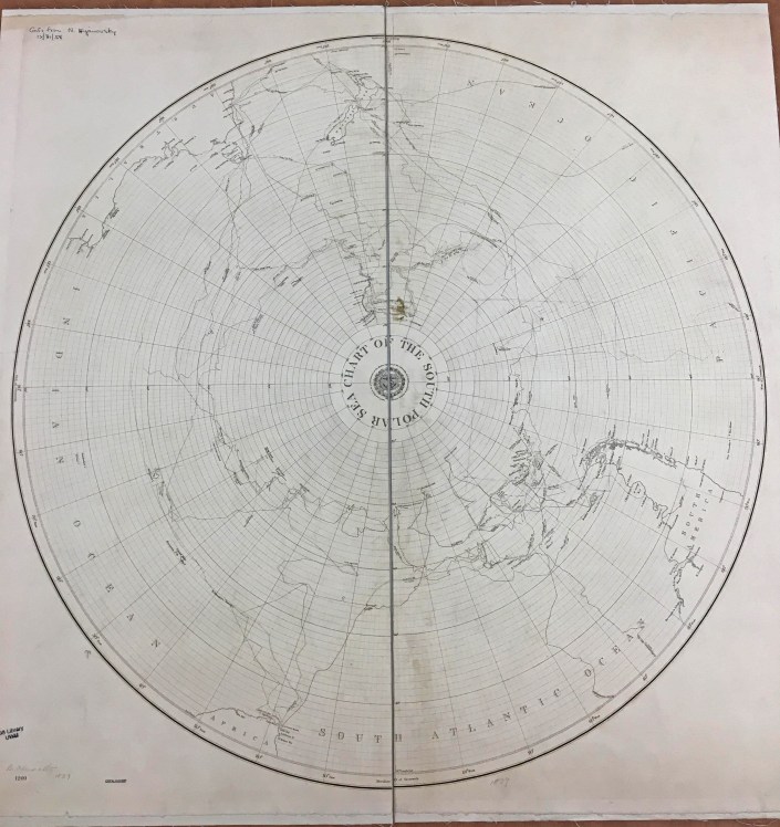
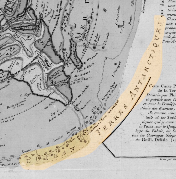
Planisphere physique by Philippe Buache, 1756
by Angie Cope
The AGS Library recently acquired a map of the world on a north polar projection. The map was made by French geographer Philippe Buache (1700-1770) who was one of the first to recognize the importance of watersheds. Buache trained under the geographer Guillaume Delisle and was married to Delisle’s daughter.
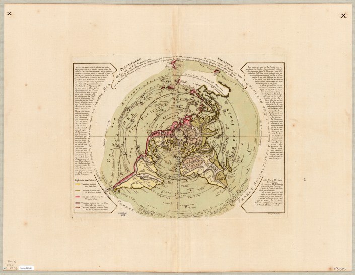
This map shows mountains and how each flows via rivers to the seas. Buache correctly identified the existence of Alaska and the Bering Strait, years before they were officially discovered.
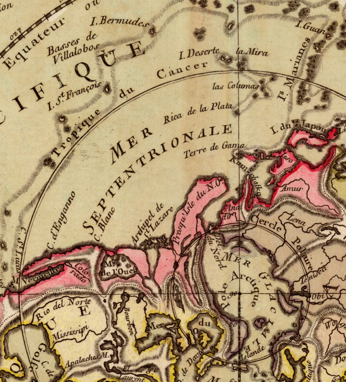
On the map he depicts an Antarctic Sea which turned out to be inaccurate.
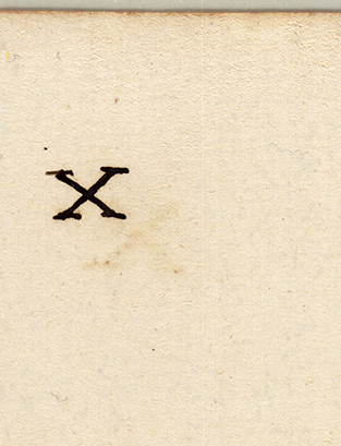
The AGS Library copy of this map is larger than other known copies at 56 x 74 cm in size (compared to 34 x 46 cm of other maps). The AGS Library map also has “Xs” in the top right and left corners on both the front and back of the map.
The text along the edges describes various expeditions and includes mention of Bouvet de Lozier’s 1738-1739 discovery of icebergs between 200-300 feet high and half a league to 2 or 3 leagues in circumference.
The AGSL copy of this map is available at the UWM Digital Map Collection. Click here to view it in more detail including zoom, pan, etc.
Library of Congress copy can be viewed in more detail here.

The 1931 Wadham Road Map
by Judy Aulik
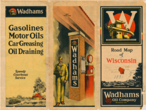 One of the author’s favorite oil companies to issue road maps is Wisconsin’s own Wadham Oil Company. Founded in 1888, early on it specialized in oils and greases: gasoline had a very limited market in the day. As highways were built and auto travel became commonplace, an obvious place to advertise was on the road maps nearly every traveler carried.
From the beginning of its gasoline marketing, Wadham produced a superior product called “straight run gasoline,” i.e., the hydrocarbon fraction obtained strictly by distilling petroleum. Compared to other fractions such as kerosene and heating oils, the gasoline suited to automotive use was rare in many oil feedstocks. Petrochemical tricks such as catalytic cracking and reforming were yet to come into use. Therefore, Wadham had to charge a small premium for its gasoline, considered to be a premium product. Indeed, the original gas was designed for a colder climate, and before the mid-1920s, was lead-free.
Wadham capitalized on its reputation by featuring images of country club life and fancy autos on its map covers. Its stations were distinctive even before architect Alexander C. Eschweiler designed his famous “Pagoda” gas stations, outstanding in their exotic nature, yet blending harmoniously in Wisconsin towns and cities.
By the time this map was issued in 1931, Wadham had been purchased by Vacuum Oil Company, precursor to Socony-Vacuum (which eventually became Mobil Oil, and culminated in ExxonMobil) However, the first three map issues under the new parent remained truer to the Wadham red, black, and yellow color scheme than to its new parent’s. Some Road Map Collectors Association members would debate whether the map shown is a Wadham map or a Milwaukee Journal Tour Club 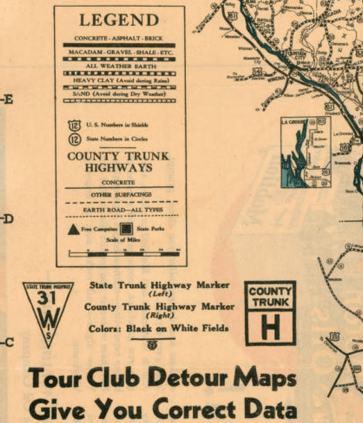 map issue. It was obtainable at the Tour Club’s Branch Stations. Fewer would opine that, as the cartographical information is that from the Wisconsin State Highway Commission, it should be considered a state official map.
Wadham’s first reported map was a 1925 issue, which was issued inside a small cardstock cover. At this point, Wadham gasoline stations were part of a Wisconsin Independent Oil Jobbers Association, and photographic evidence shows limited use of the association’s spread eagle trademark and signage. The next map considered by the RMCA to be a Wadham issue dates to 1932. The 1933 map used Langwith cartography; the 1934 cartographer is unknown; and the remainder, issued from 1935-1940, used General Drafting cartography, as did the Socony-Vacuum maps of the era. By 1935, the Mobil Pegasus had replaced the chemical industry imagery of the Wadham signage.
Does anyone else know of Wadham maps from the 1926-1930 range? If so, the author would like to know of their existence in detail.
View this map at UWM’s AGSL Digital Map Collection
Road Maps in Transition: 1920-1925
by Judy Aulik
Wisconsin officially numbered and sign posted its highways between 1916 and 1918, following the state trunk highway system (STH) designed by A.R. Hirst. Illinois followed in 1918 with its first round of state bond highways (SBI), and Michigan began its M system in 1919. After a five year gap, when Rand McNally resumed publishing road maps in 1917, later coupled with a proprietary, rudimentary, coated cardboard road marking system and an arbitrary space saving numbering system, it resulted in a peculiar set of road maps with five distinct highway designations, including the blazed trails, such as the Lincoln Highway. Had Rand McNally chosen the detail allowed by Wisconsin’s unusual county trunk highway lettering systems, it would have had six!
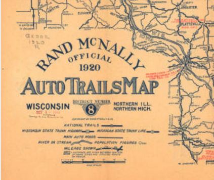
The Wisconsin State Historical Society has digitized maps of this era, as they have unquestionably passed out of copyright. Wisconsin, northern Michigan, and northern Illinois comprise District No. 8 in the Auto Trails Map series. Cartographer John Brink had an entry in a company contest which won him $100. His big idea: make a clearer highway map by numbering the major roads and trails, using a map legend which assigns a Rand McNally route number to each trail.
However, the decluttering concept fell by the wayside as his employer began to sell advertising, primarily for garages and hotels. printed in red in the clear space left.
Clearly, the extra information could prove helpful to the auto tourist. However, Brink’s Rand McNally route numbers, in white on a dark rectangle, generally conflicted with the route numbers used by the states. For example, the National Parks Pike, its eastern terminus in Madison, was designated as No. 9 on the Rand system; STH 19 (designating the highway as the 9th longest in Wisconsin) from Madison west; and blazed in red, black, and white for the National Parks Pike. After 1926, the Federal Highway system, which took over the best state routes, cleared up the confusion. The No. 9 route east of the capital city eventually became US 151; plus STH 19 west, on into Iowa (Primary Route 19; also the National Parks Pike), US 18.
Other highways the Federal Highway System also subsumed included SBI 4, which became US 66; a westerly stretch of the Yellowstone Trail in north central Wisconsin, which became US 10; and the mother of all renamings: the Ulysses S. Grant Memorial Highway (ca. 1915), which became SBI 5 (ca. 1918-1967), which also was co-blazed as the poorly publicized and long forgotten Atlantic-Yellowstone-Pacific Trail (1923, per the Iowa DoT) in northern Illinois, which was taken over by US 20 (ca. 1938, now Business US 20 in segments). Confusing, yes, but that’s why road maps and highway history are so fascinating!
Sources:
http://cdm15932.contentdm.oclc.org/cdm/ref/collection/maps/id/14541
https://iowadot.gov/autotrails/atlantic-yellowstone-pacific-highway
Special thanks to the AGSL guest blogger, Judy Aulik. With an extensive road map collection of her own, Judy Aulik has served as past President of the Road Map Collectors Association, an organization founded in 1996. Now boasting a membership of several hundred in the US, Canada, and Europe, the club publishes a quarterly newsletter, has a website, Facebook page, and hosts an annual “Road Map Expo.” Judy is a retired Adult Services Librarian with a PhD from UW-Madison. She recently spoke to the Wisconsin Map Society about the history of the Milwaukee Journal Tour Club, and its influence on highway signage and mapping.
- ← Previous
- 1
- …
- 3
- 4
- 5
- Next →
